Category:Cholmondeston
Gezinti kısmına atla
Arama kısmına atla
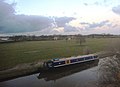
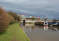
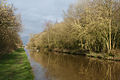
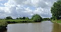
English: Cholmondeston is a village (at SJ 628 599) and civil parish in the unitary authority of Cheshire East and the ceremonial county of Cheshire, England. The village lies 5 miles to the north west of Nantwich. Nearby villages include Aston juxta Mondrum, Barbridge, Calveley and Wettenhall. The Crewe–Chester railway line and the Middlewich branch of the Shropshire Union Canal run east–west through the parish, and the Venetian Marina is on the canal by Cholmondeston Bridge.
İngiltere'nin Cheshire kontluğunda bulunan bir civil parish .jpg) | |||||
| Medya yükle | |||||
| Nedir | |||||
|---|---|---|---|---|---|
| Konumu | Cheshire East, Cheshire, Kuzey-Batı İngiltere, İngiltere | ||||
 | |||||
"Cholmondeston" kategorisindeki ortam dosyaları
Bu kategoride yer alan toplam 65 dosyanın 65 adedi aşağıdadır.
-
 Approaching Cholmondeston Lock - geograph.org.uk - 5399007.jpg 1.280 × 850; 499 KB
-
 Autumnal canal bank - geograph.org.uk - 2171362.jpg 480 × 640; 96 KB
-
 Benyon's Bridge (No 4), Middlewich Branch - geograph.org.uk - 5211818.jpg 1.024 × 768; 204 KB
-

-
 Between Winsford Rd and the Canal - geograph.org.uk - 4570389.jpg 640 × 395; 36 KB
-
 Boat approaching - geograph.org.uk - 2171349.jpg 640 × 480; 97 KB
-
 Boatyard services at Venetian Marina - geograph.org.uk - 4597508.jpg 640 × 427; 67 KB
-
 Bridge number 5 - geograph.org.uk - 4548655.jpg 4.608 × 3.456; 3,92 MB
-
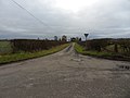
 Calveley Green Lane - geograph.org.uk - 6315826.jpg 1.024 × 683; 269 KB
-
 Canal near Aston Juxta Mondrum, Cheshire - geograph.org.uk - 2825193.jpg 1.024 × 623; 309 KB
-
 Canal with swans - geograph.org.uk - 2171357.jpg 640 × 480; 89 KB
-
 Canalside field of maize near Crossbanks Farm - geograph.org.uk - 5211810.jpg 1.024 × 615; 115 KB
-

-

-
-
 Cholmondeston (geograph 6797067).jpg 5.951 × 3.537; 1,84 MB
-
 Cholmondeston - The Limes.jpg 640 × 458; 144 KB
-

-
 Cholmondeston Lock.jpg 1.200 × 885; 485 KB
-
 Clan line number 35028 - geograph.org.uk - 4548647.jpg 1.200 × 869; 303 KB
-
 Crewe from the west - geograph.org.uk - 2107505.jpg 2.048 × 1.536; 1,27 MB
-
 Crop of haws - geograph.org.uk - 2171372.jpg 640 × 480; 105 KB
-
 Daisy lane - geograph.org.uk - 2247962.jpg 4.000 × 3.000; 4,92 MB
-
 Fishing on the Middlewich Branch Canal - geograph.org.uk - 5600290.jpg 1.280 × 851; 296 KB
-
 Flat farmland - geograph.org.uk - 4565856.jpg 640 × 426; 34 KB
-
 Gates Farm Cholmondeston.jpg 1.200 × 862; 559 KB
-

-
 Grazing, Cholmondeston - geograph.org.uk - 5197629.jpg 640 × 412; 29 KB
-
 Lock at bridge 5 - geograph.org.uk - 4548623.jpg 4.608 × 3.456; 3,61 MB
-

-

-
-

-
 Middlewich Branch, between bridges 5 and 6 - geograph.org.uk - 5211793.jpg 1.024 × 768; 188 KB
-
 Narrowboat, Shropshire Union Canal - geograph.org.uk - 4570660.jpg 640 × 462; 44 KB
-
 Pasture Cholmondeston.jpg 1.200 × 800; 332 KB
-
-
 Poplar Farmhouse Woodgreen - geograph.org.uk - 2698113.jpg 3.072 × 2.304; 3,39 MB
-
 Railway bridge - geograph.org.uk - 4548628.jpg 4.608 × 3.456; 3,67 MB
-
 Railway bridge Cholmondeston.jpg 1.200 × 829; 366 KB
-
 Rosebank walk - geograph.org.uk - 2247972.jpg 4.000 × 3.000; 5,02 MB
-
-
 S U canal-Middlewich branch - geograph.org.uk - 4548608.jpg 4.608 × 3.456; 3,71 MB
-
 Shropshire Union Canal - geograph.org.uk - 4570665.jpg 640 × 426; 39 KB
-
 Shropshire Union Canal Cholmondeston.jpg 1.200 × 800; 338 KB
-
 Shropshire Union Canal Cholmondeston2.jpg 1.200 × 800; 502 KB
-
 Small wooded pond - geograph.org.uk - 4565851.jpg 640 × 426; 34 KB
-
 Steps on Cholmondeston Lock - geograph.org.uk - 1458625.jpg 503 × 640; 189 KB
-
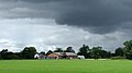
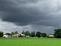 Storm clouds over Cheshire farmland - geograph.org.uk - 2825231.jpg 1.024 × 768; 361 KB
-

-
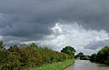
 The Cheshire Plain - geograph.org.uk - 4565845.jpg 640 × 322; 25 KB
-
 The Cheshire Plain - geograph.org.uk - 4565850.jpg 640 × 426; 36 KB
-
 The Cheshire Plain - geograph.org.uk - 4565857.jpg 640 × 426; 34 KB
-
 Top bend - geograph.org.uk - 2248085.jpg 4.000 × 3.000; 5,73 MB
-
 Top junction - geograph.org.uk - 2247944.jpg 4.000 × 3.000; 4,92 MB
-
 Top lane - geograph.org.uk - 2247938.jpg 4.000 × 3.000; 4,95 MB
-
 Top Tee - geograph.org.uk - 2247931.jpg 2.326 × 3.832; 2,75 MB
-
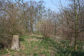 Trig point Cholmondeston.jpg 1.200 × 800; 591 KB
-
 Tyre track - geograph.org.uk - 2247915.jpg 4.000 × 3.000; 5,19 MB
-
 Tyred path - geograph.org.uk - 2247924.jpg 3.000 × 4.000; 5,82 MB
-
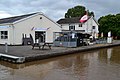
 Venetian Marina - geograph.org.uk - 5399033.jpg 1.280 × 851; 410 KB
-
 Venetian Marina Cholmondeston.jpg 1.200 × 800; 278 KB
-
 Venetian Marina Cholmondeston2.jpg 1.200 × 800; 321 KB
-

-


,_Middlewich_Branch_-_geograph.org.uk_-_5211818.jpg)


_from_Cholmondeston_Lock_-_geograph.org.uk_-_5211806.jpg)


