Category:Cilycwm
Aller à la navigation
Aller à la recherche
village britannique   | |||||
| Téléverser des médias | |||||
| Nature de l’élément | |||||
|---|---|---|---|---|---|
| Lieu | Carmarthenshire, pays de Galles | ||||
| Statut patrimonial |
| ||||
| Population |
| ||||
| Superficie |
| ||||
 | |||||
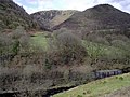
Cymraeg: Pentref a chymuned yn Sir Gaerfyrddin yw Cilycwm. Saif ar Afon Gwenlais, ychydig i'r gogledd o'r fan lle mae'n ymuno ag Afon Tywi ac i'r gogledd o dref Llanymddyfri. Mae'r eglwys, sydd wedi ei chysegru i Sant Mihangel, yn dyddio o'r 15fed ganrif, a cheir murluniau diddorol ynddi. Ceir ywen enfawr yn y fynwent.
Sous-catégories
Cette catégorie comprend 3 sous-catégories, dont les 3 ci-dessous.
C
P
- Pont Dolauhirion (3 F)
- Porthyrhyd, Llanwrda (12 F)
Média dans la catégorie « Cilycwm »
Cette catégorie comprend 359 fichiers, dont les 200 ci-dessous.
(page précédente) (page suivante)-
 A track in the rain - geograph.org.uk - 2585649.jpg 640 × 480 ; 100 kio
-
 Afon Doethie - geograph.org.uk - 2910115.jpg 1 500 × 1 125 ; 1,75 Mio
-
 Afon Dunant cascading over the road (geograph 7701484).jpg 3 024 × 4 032 ; 4,3 Mio
-
 Afon Dunant in flood (geograph 7701478).jpg 4 032 × 3 024 ; 6,14 Mio
-
 Afon Gwenlais Bridge - geograph.org.uk - 4156155.jpg 640 × 480 ; 147 kio
-
 Afon Twyi, Gallt-y-Bere - geograph.org.uk - 5696391.jpg 4 845 × 3 451 ; 4,55 Mio
-
 Afon Twyi-Towey - geograph.org.uk - 4673341.jpg 1 024 × 680 ; 421 kio
-
 Afon Tywi - geograph.org.uk - 389981.jpg 640 × 427 ; 113 kio
-
 Afon Tywi north of Rhandirmwyn, Carmarthenshire - geograph.org.uk - 2359610.jpg 800 × 600 ; 266 kio
-
 Afon Tywi north-west of Rhandirmwyn - geograph.org.uk - 2361513.jpg 800 × 570 ; 312 kio
-

-
-

-

-
 Afon Tywi-River Towy - geograph.org.uk - 1132545.jpg 640 × 481 ; 193 kio
-
 Ancient cairn close to the summit of Crugiau Merched - geograph.org.uk - 2914713.jpg 1 500 × 843 ; 1,05 Mio
-
 Banc Bleandyffyn - geograph.org.uk - 975355.jpg 640 × 426 ; 85 kio
-
 Banc Cwm Gerwyn - geograph.org.uk - 4099640.jpg 640 × 429 ; 83 kio
-
 Banc Llynowen - geograph.org.uk - 974381.jpg 640 × 426 ; 89 kio
-
 Banc Main - geograph.org.uk - 5604815.jpg 640 × 480 ; 72 kio
-
 Barn at Dyflyn Farm - geograph.org.uk - 4156254.jpg 640 × 480 ; 79 kio
-
 Barn at Rhydygroes - geograph.org.uk - 2909627.jpg 1 500 × 1 125 ; 2,06 Mio
-
 Barn in the Twyi valley - geograph.org.uk - 4673345.jpg 800 × 531 ; 145 kio
-
 Bridge crossing Nant y Gelynen - geograph.org.uk - 4688196.jpg 800 × 531 ; 138 kio
-
 Bridge on the track - geograph.org.uk - 821478.jpg 640 × 480 ; 165 kio
-
 Bridge over a stream - geograph.org.uk - 4675032.jpg 800 × 531 ; 170 kio
-
 Bridge over Afon Tywi - geograph.org.uk - 3497296.jpg 640 × 480 ; 574 kio
-
 Bridge over Afon Tywi, Galt-y-Bere - geograph.org.uk - 5696368.jpg 640 × 426 ; 102 kio
-
 Bridge over Afon Tywi-Towey - geograph.org.uk - 4673907.jpg 1 024 × 680 ; 335 kio
-
 Bridge over the Afon Doethie looking south - geograph.org.uk - 2379545.jpg 640 × 480 ; 118 kio
-
 Bridleway crossing rocks - geograph.org.uk - 2909372.jpg 1 500 × 1 125 ; 2,25 Mio
-
 Bwlch tre Banau - geograph.org.uk - 3824011.jpg 1 600 × 900 ; 275 kio
-
 Bwlch tre Banau farm and B^B - geograph.org.uk - 3822924.jpg 1 024 × 768 ; 201 kio
-
 Caio Forest - geograph.org.uk - 984608.jpg 640 × 426 ; 66 kio
-
 Calvinist Methodist Chapel - geograph.org.uk - 509963.jpg 600 × 450 ; 62 kio
-
 Capel Cwmsarnddu - Cwmsarnddu Chapel - geograph.org.uk - 4208789.jpg 640 × 480 ; 77 kio
-
 Capel y Groes (geograph 7700593).jpg 1 536 × 2 048 ; 1,04 Mio
-
 Capel Y Groes.jpg 4 032 × 3 024 ; 2,63 Mio
-

-
 Cefn Gwenffrwd - geograph.org.uk - 4719246.jpg 640 × 480 ; 105 kio
-
 Cefn Gwernffrwd 1 prehistoric stone row - geograph.org.uk - 6413519.jpg 921 × 550 ; 294 kio
-
 Cefn Gwernffrwd 2 prehistoric stone row and barrow - geograph.org.uk - 6413529.jpg 1 024 × 457 ; 187 kio
-
 Chapel in Porthyrhyd - geograph.org.uk - 4675143.jpg 1 024 × 680 ; 311 kio
-
 Cilycwm church - geograph.org.uk - 4673919.jpg 800 × 531 ; 110 kio
-
 Cilycwm church - geograph.org.uk - 4673921.jpg 531 × 800 ; 126 kio
-
 Cilycwm School - geograph.org.uk - 4156211.jpg 640 × 480 ; 81 kio
-
 Cilycwm School - geograph.org.uk - 4673974.jpg 800 × 531 ; 138 kio
-
 Cilycwm village - geograph.org.uk - 539879.jpg 640 × 480 ; 126 kio
-
 Country road in the Nant Melyn valley - geograph.org.uk - 4688176.jpg 800 × 531 ; 127 kio
-
 Country road near Allt Rhiw'r-hwch Uchaf - geograph.org.uk - 4676098.jpg 800 × 531 ; 134 kio
-
 Country road near Allt Rhiw'r-hwch Uchaf - geograph.org.uk - 980015.jpg 640 × 426 ; 65 kio
-
 Country road near Llandovery - geograph.org.uk - 1132528.jpg 640 × 481 ; 115 kio
-
 Country road near Llandovery - geograph.org.uk - 1132619.jpg 640 × 481 ; 154 kio
-
 Country road near Troedrhiwbeynon - geograph.org.uk - 4688202.jpg 800 × 531 ; 141 kio
-
 Country road to Cilycwm - geograph.org.uk - 1134331.jpg 640 × 481 ; 149 kio
-
 Country road to the west of Siloh - geograph.org.uk - 983003.jpg 640 × 426 ; 66 kio
-
 Craig Bron y Cwrt, Rhandirmwyn - geograph.org.uk - 1982294.jpg 690 × 518 ; 172 kio
-
 Craig Llech-gwynt - geograph.org.uk - 5604672.jpg 640 × 480 ; 74 kio
-
 Craig y Rhaeadr - geograph.org.uk - 4099407.jpg 640 × 480 ; 129 kio
-
 Cribyn Du - geograph.org.uk - 4379404.jpg 640 × 480 ; 111 kio
-
 Crugiau Merched - geograph.org.uk - 34847.jpg 640 × 314 ; 31 kio
-
 Crugiau Merched - geograph.org.uk - 4099284.jpg 640 × 480 ; 82 kio
-
 Cwm Dunant - geograph.org.uk - 984776.jpg 640 × 426 ; 76 kio
-
 Cwm Fran - geograph.org.uk - 975314.jpg 640 × 426 ; 92 kio
-
 Cwm Frân - geograph.org.uk - 975373.jpg 640 × 426 ; 89 kio
-
 Cwm Gwenlais - geograph.org.uk - 34844.jpg 640 × 408 ; 93 kio
-
 Cwm House.jpg 4 032 × 3 024 ; 3,52 Mio
-
 Cwm Merchon - geograph.org.uk - 975396.jpg 640 × 426 ; 93 kio
-
 Cwm Mynys - geograph.org.uk - 4217100.jpg 640 × 480 ; 148 kio
-
-

-
 Dau lwybr cyhoeddus - Two footpaths - geograph.org.uk - 6024254.jpg 1 024 × 768 ; 277 kio
-
 Efail Fach - geograph.org.uk - 6024398.jpg 1 024 × 768 ; 265 kio
-
 Farm overlooking Cil-y-cwm Road - geograph.org.uk - 6401227.jpg 5 184 × 3 456 ; 7,04 Mio
-
 Farmland above Allt Rhiw'r-hwch Uchaf - geograph.org.uk - 4676101.jpg 800 × 531 ; 108 kio
-
 Farmland above the Twyi valley - geograph.org.uk - 983032.jpg 640 × 426 ; 75 kio
-
 Farmland around Llwyn-celyn - geograph.org.uk - 980011.jpg 640 × 426 ; 64 kio
-
 Farmland east of Cilcym - geograph.org.uk - 4674040.jpg 800 × 531 ; 112 kio
-
 Farmland in the Towy Valley - geograph.org.uk - 1132573.jpg 640 × 481 ; 167 kio
-
 Farmland in the Towy Valley - geograph.org.uk - 1132645.jpg 640 × 481 ; 148 kio
-
 Farmland in the Twyi valley - geograph.org.uk - 980022.jpg 640 × 426 ; 83 kio
-
 Farmland near Allt Rhiw'r-hwch Uchaf - geograph.org.uk - 980016.jpg 640 × 426 ; 76 kio
-
 Farmland near Cilycwm - geograph.org.uk - 1134296.jpg 640 × 481 ; 92 kio
-
 Farmland near Cilycwm - geograph.org.uk - 975303.jpg 640 × 426 ; 94 kio
-
 Farmland near Troed-y-rhiw - geograph.org.uk - 1132515.jpg 640 × 481 ; 164 kio
-
 Farmland north of Rhandie-waunau - geograph.org.uk - 4675015.jpg 800 × 531 ; 126 kio
-
 Farmland south-east of Cilycwm - geograph.org.uk - 4675008.jpg 1 024 × 680 ; 344 kio
-
 Felled trees means better views - geograph.org.uk - 1498467.jpg 640 × 480 ; 143 kio
-
 Ffarm Rhiw'r Hwch Uchaf - geograph.org.uk - 4208891.jpg 640 × 480 ; 89 kio
-
 Fforest, Dyffryn Tywi - geograph.org.uk - 5696922.jpg 5 179 × 3 451 ; 6,15 Mio
-
 Field and woodland - geograph.org.uk - 4675068.jpg 800 × 531 ; 133 kio
-
 Field below Allt Tirisaf - geograph.org.uk - 4673355.jpg 800 × 531 ; 151 kio
-
 Field beside Nant Melyn - geograph.org.uk - 4688164.jpg 1 024 × 680 ; 246 kio
-
 Field beside Pen-y-banc Uchaf - geograph.org.uk - 4675051.jpg 1 024 × 680 ; 265 kio
-
 Field by the Afon Tywi - geograph.org.uk - 1339907.jpg 640 × 428 ; 157 kio
-
 Field gate and stream, Cil-y-cwm Road - geograph.org.uk - 6401217.jpg 5 179 × 3 451 ; 5,5 Mio
-
 Field near Troed -y-rhiw - geograph.org.uk - 800341.jpg 640 × 428 ; 132 kio
-
 Fields, trees and shadows - geograph.org.uk - 3497336.jpg 640 × 480 ; 364 kio
-
 Footpath East - geograph.org.uk - 4156188.jpg 480 × 640 ; 110 kio
-
 Footpath in Cwm-y-Rhaiadr forest - geograph.org.uk - 1496989.jpg 640 × 480 ; 100 kio
-
 Footpath near Cilycwm - geograph.org.uk - 1134315.jpg 640 × 481 ; 165 kio
-
 Footpath to Rhiw Gilgwyn - geograph.org.uk - 974370.jpg 640 × 426 ; 98 kio
-
 Forestry road in Coed Bryn Arau Duon - geograph.org.uk - 2913129.jpg 1 500 × 843 ; 1,44 Mio
-
 Forestry track and car park, Cwm Rhaeadr forest - geograph.org.uk - 3497345.jpg 640 × 480 ; 589 kio
-

-
 Gateway to hay field near Llandovery - geograph.org.uk - 979998.jpg 640 × 426 ; 80 kio
-
 Ger Blaen Dyffryn - Near Blaen Dyffryn - geograph.org.uk - 5137110.jpg 640 × 480 ; 96 kio
-
 Ger Cae'r Beili - Near Cae'r Beili - geograph.org.uk - 4099548.jpg 640 × 480 ; 127 kio
-
 Ger Cwm Merchon - Near Cwm Merchon - geograph.org.uk - 5604568.jpg 640 × 480 ; 87 kio
-
 Ger Ffarm Trebannau - Near Trebannau Farm - geograph.org.uk - 4200256.jpg 640 × 480 ; 100 kio
-
 Ger Nant Rhyd Ifor - Near Nant Rhyd Ifor - geograph.org.uk - 4374519.jpg 640 × 480 ; 86 kio
-
 Ger Penstacan - Near Penstacan - geograph.org.uk - 5604538.jpg 640 × 480 ; 139 kio
-
 Giant slab above Nant Rhaeadr falls - geograph.org.uk - 469878.jpg 640 × 362 ; 92 kio
-

-
 Heather and tussock - geograph.org.uk - 1498459.jpg 640 × 480 ; 156 kio
-
 Hen fynwent Soar - Soar's old graveyard - geograph.org.uk - 6330227.jpg 1 024 × 768 ; 279 kio
-
 Hen Heol - Old Road - geograph.org.uk - 4379413.jpg 640 × 480 ; 102 kio
-
 Hen heol ddiwyneb - Old unsurfaced Road - geograph.org.uk - 4099576.jpg 640 × 480 ; 100 kio
-
 Henllys Lodge - geograph.org.uk - 4156277.jpg 640 × 480 ; 90 kio
-
 Henllys, near Llandovery - geograph.org.uk - 190361.jpg 640 × 480 ; 76 kio
-
 Heol ar gau - Road Closed - geograph.org.uk - 4372363.jpg 640 × 480 ; 87 kio
-
 House in the Twyi valley - geograph.org.uk - 4673350.jpg 800 × 531 ; 164 kio
-
 Houses in Cilycwm - geograph.org.uk - 4673940.jpg 800 × 531 ; 94 kio
-
 Islaw Pen Lifau - Below Pen Lifau - geograph.org.uk - 5137097.jpg 640 × 480 ; 95 kio
-
 Junction of tracks in Caio Forest - geograph.org.uk - 984707.jpg 640 × 426 ; 83 kio
-
 Lan Ddu - geograph.org.uk - 5137115.jpg 640 × 480 ; 96 kio
-
 Lane near Bwlchcymanfa - geograph.org.uk - 980000.jpg 640 × 426 ; 75 kio
-
 Lane to Troed-y-rhiw-dinas - geograph.org.uk - 6400927.jpg 5 179 × 3 451 ; 4,34 Mio
-
 Late afternoon in Afon Gwanlas Valley near Cilycwm - geograph.org.uk - 6408786.jpg 1 800 × 1 200 ; 307 kio
-
 Llwybr Allt Rhyd y Groes Path - geograph.org.uk - 4372352.jpg 640 × 480 ; 92 kio
-
 Llwybr ar lan Nant Nawmor - Path alongside Nawmor Stream - geograph.org.uk - 6024350.jpg 1 024 × 768 ; 321 kio
-

-
 Llwybr Banc Cae Glas Path - geograph.org.uk - 4200245.jpg 640 × 480 ; 71 kio
-
 Llwybr Cae'r Beili - Cae'r Beili Path - geograph.org.uk - 6321490.jpg 1 024 × 768 ; 404 kio
-
 Llwybr Cae'r Beili - Cae'r Beili Path - geograph.org.uk - 6321493.jpg 1 024 × 767 ; 308 kio
-
 Llwybr Ceffyl - Bridleway - geograph.org.uk - 4099428.jpg 640 × 480 ; 82 kio
-
 Llwybr ceffyl Abermarlais - Abermarlais bridleway - geograph.org.uk - 6024294.jpg 1 024 × 768 ; 361 kio
-

-
 Llwybr Ceffyl Cwm Mynys Bridleway - geograph.org.uk - 4217108.jpg 640 × 480 ; 138 kio
-

-
 Llwybr Cilycwm - Cilycwm Path - geograph.org.uk - 6024650.jpg 1 024 × 768 ; 293 kio
-
 Llwybr Cilycwm - Cilycwm Path - geograph.org.uk - 6024658.jpg 1 024 × 768 ; 233 kio
-

-
 Llwybr Erryd - Erryd Path - geograph.org.uk - 6024332.jpg 1 024 × 768 ; 314 kio
-
 Llwybr Ffarm Bwlch Trebannau Farm Path - geograph.org.uk - 4200262.jpg 640 × 480 ; 85 kio
-
 Llwybr Ffarm Nant y Car Fawr Farm Path - geograph.org.uk - 4200205.jpg 640 × 480 ; 142 kio
-
 Llwybr Ffarm Nant y Car Fawr Farm Path - geograph.org.uk - 4200208.jpg 640 × 480 ; 92 kio
-
 Llwybr Ffarm Rhiw'r Hwch Uchaf Path - geograph.org.uk - 4209636.jpg 640 × 480 ; 130 kio
-
 Llwybr Ffarm Trebannau - Trebannau Farm path - geograph.org.uk - 4208936.jpg 640 × 480 ; 75 kio
-
 Llwybr ger Craig Rhosan - Path near Craig Rhosan - geograph.org.uk - 6020514.jpg 1 024 × 768 ; 237 kio
-
 Llwybr ger Glanrhosan - Footpath near Glanrhosan - geograph.org.uk - 6020564.jpg 1 024 × 768 ; 332 kio
-
 Llwybr ger Waun Croiddur - Path near Waun Croiddur - geograph.org.uk - 6024386.jpg 1 024 × 768 ; 296 kio
-
 Llwybr glanafon - Riverside path - geograph.org.uk - 6020467.jpg 1 024 × 768 ; 364 kio
-
 Llwybr Glanrhosan - Glanrhosan Path - geograph.org.uk - 6020557.jpg 1 024 × 768 ; 328 kio
-
 Llwybr Glyn Gell Path - geograph.org.uk - 4200234.jpg 640 × 480 ; 79 kio
-
 Llwybr Home Farm - Home Farm Path - geograph.org.uk - 6020541.jpg 1 024 × 768 ; 235 kio
-
 Llwybr Lan-ddu - Lan-ddu Path - geograph.org.uk - 6380957.jpg 1 024 × 768 ; 209 kio
-
 Llwybr Llwyn Celyn - Llwyn Celyn path - geograph.org.uk - 4208850.jpg 640 × 480 ; 150 kio
-
 Llwybr Maesgwaelod - Maesygwaelod Path - geograph.org.uk - 6024341.jpg 1 024 × 768 ; 312 kio
-
 Llwybr Maesygwaelod - Maesygwalod Path - geograph.org.uk - 6024367.jpg 1 024 × 768 ; 340 kio
-

-
 Llwybr Pen Fedw Fach - Pen Fedw Fach Path - geograph.org.uk - 6020580.jpg 1 024 × 768 ; 242 kio
-
 Llwybr Pentre Cwn - Pentre Cwn Path - geograph.org.uk - 5137105.jpg 640 × 480 ; 94 kio
-
 Llwybr Tan Lifau - Tan Lifau - geograph.org.uk - 5137075.jpg 640 × 480 ; 140 kio
-
 Llwybr Ty Newydd Path - geograph.org.uk - 4208996.jpg 640 × 480 ; 88 kio
-
 Llwybr y coedwig - Woodland path - geograph.org.uk - 6020480.jpg 1 024 × 768 ; 352 kio
-
 Llyswen.jpg 4 032 × 3 024 ; 2,13 Mio
-
 Lower slope of Craig Diferion - geograph.org.uk - 5696143.jpg 5 179 × 3 451 ; 4,16 Mio
-
 Maen Bach - geograph.org.uk - 4099378.jpg 640 × 480 ; 87 kio
-
 Maen Bach Standing Stone, Mynydd Mallaen - geograph.org.uk - 1220615.jpg 640 × 480 ; 74 kio
-
 Mosaic in Cwm-y-Rhaiadr Forest - geograph.org.uk - 1421209.jpg 640 × 480 ; 134 kio
-
 Moss Covered Bridge Parapet - geograph.org.uk - 4156303.jpg 640 × 480 ; 142 kio
-

-
 Mynwent Capel Seion Chapel Graveyard - geograph.org.uk - 4095877.jpg 640 × 480 ; 86 kio
-
 Mynydd Mallaen - geograph.org.uk - 1421331.jpg 640 × 480 ; 53 kio
-
 Mynydd Mallaen - geograph.org.uk - 4099384.jpg 640 × 480 ; 93 kio
-
 Mynydd Mallaen - geograph.org.uk - 4099392.jpg 640 × 480 ; 90 kio
-
 Mynydd Mallaen - geograph.org.uk - 4099601.jpg 640 × 480 ; 85 kio
-
 Mynydd Mallaen - geograph.org.uk - 4099611.jpg 640 × 480 ; 67 kio
-
 Mynydd Mallaen - geograph.org.uk - 5604611.jpg 640 × 480 ; 75 kio
-
 Mynydd Mallaen Plateau - geograph.org.uk - 1220641.jpg 640 × 480 ; 74 kio
-
 Mynydd Mallaen Plateau - geograph.org.uk - 1220664.jpg 640 × 480 ; 65 kio
-
 Nant Melyn valley - geograph.org.uk - 4688174.jpg 800 × 531 ; 135 kio
-
 Nant y Gelynen - geograph.org.uk - 4688193.jpg 531 × 800 ; 166 kio
-
 Neuadd Fawr Arms, Cilycwm - geograph.org.uk - 4674032.jpg 1 024 × 680 ; 238 kio
-
 Neuadd Fawr Arms.jpg 4 032 × 3 024 ; 3,27 Mio
-
 Northern approach to Cilycwm - geograph.org.uk - 3497324.jpg 640 × 480 ; 365 kio
-
 Not pretty - geograph.org.uk - 1498444.jpg 640 × 480 ; 145 kio
-
 Old farmhouse at Berrisbrook - geograph.org.uk - 3078516.jpg 640 × 480 ; 71 kio
-
 Old Gateway at Home Farm - geograph.org.uk - 4156169.jpg 640 × 480 ; 66 kio
-
 Old Post Office at Porthyrhyd - geograph.org.uk - 3078498.jpg 640 × 480 ; 59 kio
-
 Old trees - geograph.org.uk - 1385191.jpg 640 × 480 ; 114 kio
-
 Ordnance Survey 1GL Bolt - geograph.org.uk - 5122101.jpg 494 × 640 ; 115 kio
-
 Ordnance Survey Cut Mark - geograph.org.uk - 4156135.jpg 480 × 640 ; 81 kio
-
 Ordnance Survey Cut Mark - geograph.org.uk - 4156147.jpg 480 × 640 ; 100 kio
-
 Ordnance Survey Cut Mark - geograph.org.uk - 4156149.jpg 640 × 480 ; 109 kio
-
 Ordnance Survey Cut Mark - geograph.org.uk - 4156160.jpg 480 × 640 ; 106 kio
-
 Ordnance Survey Cut Mark - geograph.org.uk - 4156178.jpg 480 × 640 ; 103 kio
-
 Ordnance Survey Cut Mark - geograph.org.uk - 4156197.jpg 480 × 640 ; 103 kio
-
 Ordnance Survey Cut Mark - geograph.org.uk - 4156205.jpg 480 × 640 ; 95 kio


.jpg)
.jpg)


.jpg)


