Category:Clopton, Suffolk
Aller à la navigation
Aller à la recherche
English: Clopton is a village in Suffolk. It is located between Ipswich and Debenham two kilometres north of Grundisburgh on the River Lark.
localité britannique du comté anglais de Suffolk | |||||
| Téléverser des médias | |||||
| Nature de l’élément | |||||
|---|---|---|---|---|---|
| Lieu |
| ||||
| Population |
| ||||
| Réputé identique à | Clopton (page en doublon, paroisse civile) | ||||
 | |||||
Sous-catégories
Cette catégorie comprend 3 sous-catégories, dont les 3 ci-dessous.
S
V
- Clopton Village Hall (4 F)
Média dans la catégorie « Clopton, Suffolk »
Cette catégorie comprend 156 fichiers, dont les 156 ci-dessous.
-
 19th century Ordnance Survey map of Clopton, Suffolk..PNG 273 × 297 ; 176 kio
-
 493rd Bomb Group Memorial - geograph.org.uk - 5220681.jpg 1 944 × 2 592 ; 2,19 Mio
-
 B1078 Ipswich Road - geograph.org.uk - 2548558.jpg 3 072 × 2 304 ; 1,21 Mio
-
 B1078 Ipswich Road - geograph.org.uk - 2548682.jpg 3 072 × 2 304 ; 1,22 Mio
-
 B1078 Ipswich Road - geograph.org.uk - 2548683.jpg 3 072 × 2 304 ; 1,33 Mio
-
 B1078 Ipswich Road - geograph.org.uk - 2548707.jpg 3 072 × 2 304 ; 1,38 Mio
-
 B1078 junction Drabb's Lane - geograph.org.uk - 2555092.jpg 3 072 × 2 304 ; 1,36 Mio
-
 B1078 junction with B1079 - geograph.org.uk - 3602991.jpg 3 478 × 2 616 ; 1,8 Mio
-
 B1078 junction with un-named lane from Catts Hill Farm - geograph.org.uk - 3602967.jpg 3 040 × 2 342 ; 1,66 Mio
-
 B1078 looking towards Potash Corner - geograph.org.uk - 2588689.jpg 3 072 × 2 304 ; 1,43 Mio
-
 B1078 northeast of Grove Farm - geograph.org.uk - 3602917.jpg 3 555 × 2 594 ; 1,06 Mio
-
 B1078 west of Grove Farm - geograph.org.uk - 3602945.jpg 3 100 × 2 599 ; 1,5 Mio
-
 B1079 at Clopton - geograph.org.uk - 2409795.jpg 3 648 × 2 736 ; 2,43 Mio
-
 B1079 Grundisburgh Road - geograph.org.uk - 2554237.jpg 3 072 × 2 304 ; 1,22 Mio
-
 B1079 Grundisburgh Road - geograph.org.uk - 2554238.jpg 3 072 × 2 304 ; 1,39 Mio
-
 B1079 Grundisburgh Road - geograph.org.uk - 2554265.jpg 3 072 × 2 304 ; 1,38 Mio
-
 B1079 Grundisburgh Road - geograph.org.uk - 2555433.jpg 2 304 × 3 072 ; 1,28 Mio
-
 B1079 Grundisburgh Road - geograph.org.uk - 2555435.jpg 3 072 × 2 304 ; 1,35 Mio
-
 B1079 Grundisburgh Road ^ Market Hill - geograph.org.uk - 2555430.jpg 3 072 × 2 304 ; 1,31 Mio
-
 B1079 Grundisburgh Road ^ Potash Corner Postbox - geograph.org.uk - 2554198.jpg 3 072 × 2 304 ; 1,64 Mio
-
 B1079 Grundisburgh Road ^ Potash Corner Postbox - geograph.org.uk - 2554275.jpg 3 072 × 2 304 ; 1,48 Mio
-
 Bally Hoo Cottage - geograph.org.uk - 2588637.jpg 3 072 × 2 304 ; 1,4 Mio
-
 Bally Hoo Cottage sign - geograph.org.uk - 2588639.jpg 3 072 × 2 304 ; 1,49 Mio
-
 Barn conversion at Manor Farm Barn, Clopton - geograph.org.uk - 6167465.jpg 6 000 × 4 000 ; 6,24 Mio
-
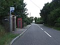 Bus Stop And Telephone Box - geograph.org.uk - 3659267.jpg 1 024 × 768 ; 209 kio
-
 Bus stop, pull-in and post-box on B1079 - geograph.org.uk - 4071606.jpg 1 599 × 1 600 ; 1,54 Mio
-
 Byway to Drabbs Lane - geograph.org.uk - 2555034.jpg 3 072 × 2 304 ; 1,5 Mio
-
 Byway to Snipe Farm Lane - geograph.org.uk - 2555636.jpg 3 072 × 2 304 ; 1,39 Mio
-
 Clop1881Occupation.png 601 × 336 ; 18 kio
-
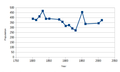 ClopPop.png 561 × 336 ; 9 kio
-
 Clopton Parish Notice Board - geograph.org.uk - 2554258.jpg 2 304 × 3 072 ; 1,48 Mio
-
 Clopton Population Structure.png 565 × 341 ; 17 kio
-
 Clopton Village Hall sign - geograph.org.uk - 2548703.jpg 3 072 × 2 304 ; 1,65 Mio
-
 Clopton War Memorial - geograph.org.uk - 5432122.jpg 2 592 × 1 944 ; 2,67 Mio
-
 Derelict farm yard at Catts Hill Farm, Clopton - geograph.org.uk - 6167433.jpg 6 000 × 4 000 ; 6,07 Mio
-
 Dodd's Farm - geograph.org.uk - 993467.jpg 640 × 480 ; 70 kio
-
 Drabb's Lane - geograph.org.uk - 2555093.jpg 3 072 × 2 304 ; 1,37 Mio
-
 Drabb's Lane - geograph.org.uk - 2555726.jpg 3 072 × 2 304 ; 1,25 Mio
-
 Drabb's Lane - geograph.org.uk - 2555821.jpg 3 072 × 2 304 ; 1,26 Mio
-
 Drabb's Lane - geograph.org.uk - 2555846.jpg 3 072 × 2 304 ; 1,3 Mio
-
 Drabbs Lane - geograph.org.uk - 2548684.jpg 3 072 × 2 304 ; 1,48 Mio
-
 Drabbs Lane - geograph.org.uk - 2548688.jpg 3 072 × 2 304 ; 1,3 Mio
-
 Drabbs Lane - geograph.org.uk - 2548699.jpg 3 072 × 2 304 ; 1,28 Mio
-
 Drabbs Lane sign - geograph.org.uk - 2548686.jpg 3 072 × 2 304 ; 1,65 Mio
-
 Entrance to the RDA Woodbridge riding centre - geograph.org.uk - 6167421.jpg 5 703 × 3 801 ; 2,67 Mio
-
 Farm Building - geograph.org.uk - 3772387.jpg 1 024 × 768 ; 289 kio
-
 Farm track near Hill Farm - geograph.org.uk - 1892879.jpg 2 736 × 3 648 ; 4,94 Mio
-
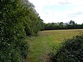
 Field to the side of the footpath to Snipe Farm Lane - geograph.org.uk - 2555820.jpg 3 072 × 2 304 ; 1,36 Mio
-
 Fields near Moat Farm Cottages - geograph.org.uk - 6167345.jpg 6 000 × 4 000 ; 6,6 Mio
-
 Footpath to Clopton Commercial Park - geograph.org.uk - 2548692.jpg 2 304 × 3 072 ; 1,69 Mio
-
 Footpath to Clopton Commericial Park - geograph.org.uk - 2548690.jpg 3 072 × 2 304 ; 1,67 Mio
-
 Footpath to Clopton Commericial Park - geograph.org.uk - 2548691.jpg 2 304 × 3 072 ; 1,65 Mio
-
 Footpath to Clopton Green - geograph.org.uk - 2548566.jpg 3 072 × 2 304 ; 1,39 Mio
-
 Footpath to Clopton Green - geograph.org.uk - 2548571.jpg 3 072 × 2 304 ; 1,33 Mio
-
 Footpath to Clopton Green - geograph.org.uk - 2555064.jpg 2 304 × 3 072 ; 1,65 Mio
-
 Footpath to Clopton Playing Field - geograph.org.uk - 2555089.jpg 2 304 × 3 072 ; 1,44 Mio
-
 Footpath to Drabb's Lane - geograph.org.uk - 2555097.jpg 3 072 × 2 304 ; 1,27 Mio
-
 Footpath to Drabb's Lane - geograph.org.uk - 2555098.jpg 3 072 × 2 304 ; 1,3 Mio
-
 Footpath to Drabb's Lane - geograph.org.uk - 2590925.jpg 3 072 × 2 304 ; 1,46 Mio
-
 Footpath to Drabbs Lane - geograph.org.uk - 2555033.jpg 2 304 × 3 072 ; 1,65 Mio
-
 Footpath to Market Hill ^ Stanway Farm - geograph.org.uk - 2559396.jpg 3 072 × 2 304 ; 1,41 Mio
-
 Footpath to Martins Lane - geograph.org.uk - 2555066.jpg 3 072 × 2 304 ; 1,45 Mio
-
 Footpath to Snipe Farm Lane - geograph.org.uk - 2555050.jpg 3 072 × 2 304 ; 1,3 Mio
-
 Footpath to Snipe Farm Lane - geograph.org.uk - 2555052.jpg 3 072 × 2 304 ; 1,27 Mio
-
 Footpath to Snipe Farm Lane - geograph.org.uk - 2555088.jpg 3 072 × 2 304 ; 1,45 Mio
-
 Footpath to Snipe Farm Lane - geograph.org.uk - 2555728.jpg 2 304 × 3 072 ; 1,63 Mio
-
 Footpath to Snipe Farm Lane - geograph.org.uk - 2555729.jpg 2 304 × 3 072 ; 1,67 Mio
-
 Footpath to Snipe Farm Lane ^ the B1078 Ipswich Road - geograph.org.uk - 2548697.jpg 3 072 × 2 304 ; 1,35 Mio
-
 Footpath to Snipe Farm Lane ^ the B1078 Ipswich Road - geograph.org.uk - 2548698.jpg 2 304 × 3 072 ; 1,49 Mio
-
 Footpath to Snipe Farm Lane ^ the B1079 Grundisburgh Road - geograph.org.uk - 2555056.jpg 3 072 × 2 304 ; 1,33 Mio
-
 Footpath to Snipe Farm Lane ^ the B1079 Grundisburgh Road - geograph.org.uk - 2555058.jpg 3 072 × 2 304 ; 1,33 Mio
-
 Footpath to the B1078 - geograph.org.uk - 2555096.jpg 3 072 × 2 304 ; 1,22 Mio
-
 Footpath to the B1078 - geograph.org.uk - 2588656.jpg 3 072 × 2 304 ; 1,63 Mio
-
 Footpath to the B1078 - geograph.org.uk - 2588660.jpg 3 072 × 2 304 ; 1,4 Mio
-
 Footpath to the B1078 Ipswich Road - geograph.org.uk - 2590924.jpg 3 072 × 2 304 ; 1,27 Mio
-
 Footpath to the B1079 Grunsdisburgh Road - geograph.org.uk - 2555044.jpg 2 304 × 3 072 ; 1,68 Mio
-
 Footpath to the B1079 Grunsdisburgh Road - geograph.org.uk - 2555045.jpg 2 304 × 3 072 ; 1,65 Mio
-
 Location With Postcode - geograph.org.uk - 3659265.jpg 1 024 × 768 ; 190 kio
-
 Main admin building USAAF Debach - geograph.org.uk - 6338603.jpg 4 608 × 3 072 ; 3,87 Mio
-
 Manor Road - geograph.org.uk - 2554302.jpg 3 072 × 2 304 ; 1,38 Mio
-
 Manor Road Postbox - geograph.org.uk - 2555026.jpg 3 072 × 2 304 ; 1,27 Mio
-
 Manor Road Postbox - geograph.org.uk - 2555028.jpg 2 304 × 3 072 ; 1,6 Mio
-
 Manor Road sign - geograph.org.uk - 2548709.jpg 2 304 × 3 072 ; 1,38 Mio
-
 Manor Road ^ Manor Road Postbox - geograph.org.uk - 2554299.jpg 3 072 × 2 304 ; 1,16 Mio
-
 Manor Road ^ Manor Road Postbox - geograph.org.uk - 2555029.jpg 3 072 × 2 304 ; 1,54 Mio
-
 Manor Road, Clopton - geograph.org.uk - 2548706.jpg 3 072 × 2 304 ; 1,47 Mio
-
 Martins Lane - geograph.org.uk - 2548553.jpg 2 304 × 3 072 ; 1,34 Mio
-
 Martins Lane - geograph.org.uk - 2548572.jpg 2 304 × 3 072 ; 1,66 Mio
-
 Martins Lane - geograph.org.uk - 3771870.jpg 1 024 × 768 ; 270 kio
-
 Moat Farm Cottages - geograph.org.uk - 3659163.jpg 1 024 × 768 ; 214 kio
-
 Mount Pleasant Farm entrance - geograph.org.uk - 2555037.jpg 3 072 × 2 304 ; 1,52 Mio
-
 New Stable Block, Clopton - geograph.org.uk - 2793114.jpg 640 × 480 ; 135 kio
-
 Pear Tree Farm - geograph.org.uk - 5371804.jpg 640 × 480 ; 330 kio
-
 Pig farm on the perimeter of the former Debach Airfield - geograph.org.uk - 6167445.jpg 6 000 × 4 000 ; 7,08 Mio
-
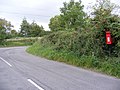
 Potash Corner Postbox - geograph.org.uk - 2554210.jpg 3 072 × 2 304 ; 1,66 Mio
-
 Potash Corner Postbox - geograph.org.uk - 2554214.jpg 2 304 × 3 072 ; 1,5 Mio
-
 Potash Corner Postbox - geograph.org.uk - 2554218.jpg 3 072 × 2 304 ; 1,64 Mio
-
 Potash Corner Postbox - geograph.org.uk - 2554221.jpg 2 304 × 3 072 ; 1,46 Mio
-
 RAF - USAAF Debach memorial - geograph.org.uk - 6338595.jpg 4 608 × 3 072 ; 6,24 Mio
-
 RAF - USAAF Debach memorial - geograph.org.uk - 6338599.jpg 3 072 × 4 608 ; 5,04 Mio
-
 Road Junction - geograph.org.uk - 3659259.jpg 1 024 × 768 ; 279 kio
-
 Road Junction - geograph.org.uk - 3842500.jpg 1 024 × 768 ; 227 kio
-
 Road junction and woodland east of Clopton Corner - geograph.org.uk - 4071318.jpg 1 600 × 1 200 ; 1,06 Mio
-
 Road junction at Clopton - geograph.org.uk - 2409788.jpg 3 648 × 2 736 ; 2,6 Mio
-
 Road junction in Drabb's Lane - geograph.org.uk - 2555443.jpg 2 640 × 1 980 ; 652 kio
-
 Road Junction near Bally Hoo Cottage - geograph.org.uk - 2588731.jpg 3 072 × 2 304 ; 1,38 Mio
-
 Road near Bally Hoo Cottage - geograph.org.uk - 2590991.jpg 3 072 × 2 304 ; 1,62 Mio
-
 Road near Bally Hoo Cottage ^ footpath to the B1078 - geograph.org.uk - 2588651.jpg 3 072 × 2 304 ; 1,62 Mio
-
 Road Scene - geograph.org.uk - 3659268.jpg 1 024 × 768 ; 224 kio
-
 Road to Burgh - geograph.org.uk - 2555440.jpg 3 072 × 2 304 ; 1,31 Mio
-
 Road to Clopton Green - geograph.org.uk - 2588717.jpg 3 072 × 2 304 ; 1,51 Mio
-
 Road to Clopton Green junction with the B1078 - geograph.org.uk - 2588685.jpg 3 072 × 2 304 ; 1,45 Mio
-
 Road to Otley near bally Hoo Cottage - geograph.org.uk - 2588741.jpg 3 072 × 2 304 ; 1,52 Mio
-
 Roadsign near Bally Hoo Cottage - geograph.org.uk - 2588733.jpg 3 072 × 2 304 ; 1,54 Mio
-
 Roadsign on Drabb's Lane - geograph.org.uk - 2555444.jpg 2 304 × 3 072 ; 1,41 Mio
-
 Roadsign on the B1078 - geograph.org.uk - 2588713.jpg 3 072 × 2 304 ; 1,46 Mio
-
 Roadsign on the B1079-Snipe Farm Lane junction - geograph.org.uk - 2555431.jpg 2 304 × 3 072 ; 1,35 Mio
-
 Roofless barn at Hill Farm, Clopton - geograph.org.uk - 6167460.jpg 6 000 × 4 000 ; 6,49 Mio
-
 Rouse Hall Gardens sign - geograph.org.uk - 2555080.jpg 3 072 × 2 304 ; 1,5 Mio
-
 Rouse Hall Road - geograph.org.uk - 2555072.jpg 3 072 × 2 304 ; 1,29 Mio
-
 Rouse Hall Road - geograph.org.uk - 2555076.jpg 3 072 × 2 304 ; 1,34 Mio
-
 Rouse Hall Road - geograph.org.uk - 2555082.jpg 3 072 × 2 304 ; 1,44 Mio
-
 Rouse Hall Road sign - geograph.org.uk - 2555074.jpg 3 072 × 2 304 ; 1,5 Mio
-
 Rouse Hall Road sign ^ Clopton Village Notice Board - geograph.org.uk - 2555078.jpg 3 072 × 2 304 ; 1,43 Mio
-
 Shop Road - geograph.org.uk - 2548720.jpg 2 304 × 3 072 ; 1,36 Mio
-
 Shop Road Postbox - geograph.org.uk - 2548717.jpg 2 304 × 3 072 ; 1,54 Mio
-
 Shop Road Postbox - geograph.org.uk - 2548719.jpg 2 304 × 3 072 ; 1,49 Mio
-
 Shop Road sign - geograph.org.uk - 2548713.jpg 3 072 × 2 304 ; 1,45 Mio
-
 Shop Road sign - geograph.org.uk - 2548714.jpg 2 304 × 3 072 ; 1,49 Mio
-
 Shop Road ^ Shop Road Postbox - geograph.org.uk - 2548716.jpg 2 304 × 3 072 ; 1,42 Mio
-
 Shop Road, Clopton - geograph.org.uk - 2548722.jpg 3 072 × 2 304 ; 1,3 Mio
-
 Shop Road, Clopton - geograph.org.uk - 2555065.jpg 2 304 × 3 072 ; 1,59 Mio
-
 Shop Road, Clopton - geograph.org.uk - 2555071.jpg 3 072 × 2 304 ; 1,36 Mio
-
 Snipe Farm Lane - geograph.org.uk - 2555030.jpg 3 072 × 2 304 ; 1,26 Mio
-
 Snipe Farm Lane - geograph.org.uk - 2555031.jpg 3 072 × 2 304 ; 1,47 Mio
-
 Snipe Farm Lane - geograph.org.uk - 2555040.jpg 3 072 × 2 304 ; 1,28 Mio
-
 Snipe Farm Lane - geograph.org.uk - 2555095.jpg 3 072 × 2 304 ; 1,37 Mio
-
 Snipe Farm Lane - geograph.org.uk - 2555423.jpg 3 072 × 2 304 ; 1,4 Mio
-
 Snipe Farm Lane - geograph.org.uk - 2555424.jpg 2 304 × 3 072 ; 1,31 Mio
-
 Snipe Farm Lane ^ the footpath to the B1079 Grunsdisburgh Road - geograph.org.uk - 2555042.jpg 3 072 × 2 304 ; 1,56 Mio
-
 St Mary's Church Rectory - geograph.org.uk - 6396071.jpg 800 × 533 ; 124 kio
-
 The B1078 looking towards Clopton Green - geograph.org.uk - 2555084.jpg 3 072 × 2 304 ; 1,45 Mio
-
 The B1078 looking towards Clopton Green - geograph.org.uk - 2555085.jpg 3 072 × 2 304 ; 1,34 Mio
-
 The B1078 looking towards Manor Road - geograph.org.uk - 2588716.jpg 3 072 × 2 304 ; 1,63 Mio
-
 The B1079 near to Potash Farm - geograph.org.uk - 2559399.jpg 3 072 × 2 304 ; 1,31 Mio
-
 The Entrance to Debach Airfield Museum - geograph.org.uk - 2548696.jpg 3 072 × 2 304 ; 1,5 Mio
-
 The entrance to Mount Pleasant Farm ^ access to the footpaths - geograph.org.uk - 2555036.jpg 3 072 × 2 304 ; 1,51 Mio
-
 The former Clopton Crown pub - geograph.org.uk - 2562502.jpg 3 648 × 2 736 ; 2,3 Mio
-
 The Laurels - geograph.org.uk - 1213596.jpg 640 × 480 ; 94 kio
-
 The living and the dead - geograph.org.uk - 6167393.jpg 6 000 × 4 000 ; 6,35 Mio
-
 Tye (of Clopton, Suffolk) arms.svg 578 × 666 ; 12 kio
-
 U.S.A.A.F. Memorial - geograph.org.uk - 3861691.jpg 1 024 × 768 ; 271 kio
-
 View from Market Hill across the fields, Clopton - geograph.org.uk - 4156238.jpg 3 572 × 2 009 ; 1,38 Mio
-
 Woodland at turning for Clopton Depot - geograph.org.uk - 4071314.jpg 1 600 × 1 200 ; 1,03 Mio
-
 Farmhouse at Manor House Farm - geograph.org.uk - 316820.jpg 640 × 449 ; 88 kio
-
 Tree And Blue Skies - geograph.org.uk - 377843.jpg 640 × 480 ; 86 kio


_arms.svg)


