Category:Clowne
Vai alla navigazione
Vai alla ricerca
parrocchia civile del Derbyshire  | |||||
| Carica un file multimediale | |||||
| Istanza di | |||||
|---|---|---|---|---|---|
| Luogo | Bolsover, Derbyshire, Midlands Orientali, Inghilterra | ||||
| Considerato essere uguale a | Clowne (pagina Wikimedia duplicata, parrocchia civile dell'Inghilterra) | ||||
| sito web ufficiale | |||||
 | |||||
Sottocategorie
Questa categoria contiene le 7 sottocategorie indicate di seguito, su un totale di 7.
C
- Clowne South railway station (4 F)
- Clowne War Memorial (1 F)
- Clowne Cross (2 F)
- The Crown, Clowne (2 F)
J
N
- Nags Head, Clowne (2 F)
File nella categoria "Clowne"
Questa categoria contiene 200 file, indicati di seguito, su un totale di 201.
(pagina precedente) (pagina successiva)-
 "The White Hart", Clowne - geograph.org.uk - 3900557.jpg 2 470 × 1 765; 1,25 MB
-
 03037 Oxcroft Colliery Disposal Point.jpg 1 603 × 1 051; 312 KB
-
 03037 Oxcroft Colliery.jpg 1 799 × 1 192; 299 KB
-
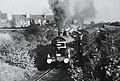
 20151 and 20062 Clowne.jpg 2 048 × 1 348; 487 KB
-
 43953 ,Clowne. (3155123860).jpg 770 × 519; 89 KB
-
 47418 Clowne.jpg 2 048 × 1 338; 405 KB
-
 47418 near Clowne.jpg 2 048 × 1 343; 498 KB
-
 92214 Clowne Sidings.jpg 2 048 × 1 307; 221 KB
-
 A view of Harlesthorpe Dam - geograph.org.uk - 4754600.jpg 5 016 × 3 719; 4,11 MB
-
 A winter view clowne church - panoramio.jpg 1 944 × 2 592; 1,44 MB
-
 A winters view of the old ticket office and portal,clowne south - panoramio.jpg 3 162 × 1 548; 1,53 MB
-
 A616 Oxcroft Way - geograph.org.uk - 5670778.jpg 640 × 481; 37 KB
-
 A616 Road in Clowne - geograph.org.uk - 2853552.jpg 3 204 × 2 344; 1,16 MB
-
 Allotments, Clowne ^ District Gardeners' Association - geograph.org.uk - 3058425.jpg 3 648 × 2 736; 4,66 MB
-
 Approaching Clowne on the A616 - geograph.org.uk - 4305132.jpg 640 × 480; 61 KB
-
 Approaching Manor Farm - geograph.org.uk - 4303832.jpg 1 600 × 1 200; 550 KB
-
 At Romeley Hall Farm - geograph.org.uk - 3900547.jpg 2 492 × 1 780; 1,42 MB
-
 B6417 at Clowne village boundary - geograph.org.uk - 4282780.jpg 640 × 481; 38 KB
-
 B6418 heading towards Clowne - geograph.org.uk - 2166063.jpg 900 × 584; 294 KB
-
 B6418 southwest of Clowne - geograph.org.uk - 2166061.jpg 900 × 613; 342 KB
-
 Barlborough Road, New Barlborough - geograph.org.uk - 4305157.jpg 640 × 480; 52 KB
-
 Border Lane - geograph.org.uk - 4115660.jpg 4 000 × 3 000; 2,07 MB
-
 Border Lane, a track near Clowne - geograph.org.uk - 2622058.jpg 768 × 1 024; 406 KB
-
 Boughton Lane - geograph.org.uk - 4305163.jpg 640 × 480; 66 KB
-
 Boughton Lane in Clowne - geograph.org.uk - 2853539.jpg 3 222 × 2 370; 1,26 MB
-
 Bridge near mitchell st clowne - panoramio.jpg 2 592 × 1 944; 1,93 MB
-
 Bridge over disused railway, Boughton Lane, Clowne - geograph.org.uk - 4303825.jpg 1 600 × 1 200; 532 KB
-
 Bus shelter at the edge of Clowne - geograph.org.uk - 3551306.jpg 800 × 515; 83 KB
-
 Bus Stop, Sheffield Road - geograph.org.uk - 113067.jpg 425 × 640; 49 KB
-
 Bus Stop, Station Road, Clowne - geograph.org.uk - 113064.jpg 640 × 425; 64 KB
-
 Byway Junction near Damsbrook Farm - geograph.org.uk - 4115672.jpg 4 000 × 3 000; 2,75 MB
-
 Cattery and Kennels, Hickingwood - geograph.org.uk - 3058420.jpg 3 648 × 2 736; 4,7 MB
-
 Characterful property on Ringer Lane, Clowne - geograph.org.uk - 3900559.jpg 1 817 × 2 422; 2,25 MB
-
 Sacred Heart Church, Clowne - geograph.org.uk - 113061.jpg 640 × 425; 93 KB
-
 Clowne - Cavendish Drive - geograph.org.uk - 1583879.jpg 640 × 480; 66 KB
-
 Clowne - Creswell Road - geograph.org.uk - 1583910.jpg 640 × 480; 75 KB
-
 Clowne - Gapstick Lane - geograph.org.uk - 1583896.jpg 640 × 480; 70 KB
-
 Clowne - Hickingwood Lane - geograph.org.uk - 1184464.jpg 640 × 480; 53 KB
-
 Clowne - Jago Avenue - geograph.org.uk - 676267.jpg 640 × 480; 68 KB
-
 Clowne - Mansfield Road (B6417) - geograph.org.uk - 702619.jpg 640 × 480; 67 KB
-
 Clowne - North Street Methodist Chapel.jpg 2 272 × 1 704; 1,71 MB
-

-
 Clowne - Sheffield Road - geograph.org.uk - 1583926.jpg 640 × 480; 57 KB
-

-

-
 Clowne - Wilson Avenue - geograph.org.uk - 676261.jpg 640 × 480; 74 KB
-
 Clowne and Barlborough burial ground - geograph.org.uk - 4303826.jpg 1 600 × 1 200; 487 KB
-
 Clowne Branch Line Greenway - geograph.org.uk - 6145369.jpg 640 × 480; 117 KB
-
 Clowne church - panoramio.jpg 2 592 × 1 944; 1,08 MB
-
 Clowne crags 2012 - panoramio.jpg 3 693 × 1 516; 1,82 MB
-
 Clowne fire station - geograph.org.uk - 2024566.jpg 640 × 427; 182 KB
-
 Clowne Fire Station - geograph.org.uk - 4305139.jpg 640 × 480; 48 KB
-
 Clowne Linear Park - geograph.org.uk - 3584525.jpg 1 600 × 1 200; 743 KB
-
 Clowne Methodist Church - geograph.org.uk - 2166160.jpg 900 × 675; 374 KB
-
 Clowne Methodist Church - geograph.org.uk - 4303829.jpg 1 600 × 1 200; 588 KB
-
 Clowne school 609445 5f0de4cb.jpg 640 × 480; 84 KB
-
 Clowne Sewage Treatment Works - geograph.org.uk - 1569030.jpg 640 × 480; 83 KB
-
 Clowne south circa 1910 - panoramio.jpg 3 268 × 2 144; 464 KB
-
 Clowne south portal,the railway closed in 1964 - panoramio.jpg 3 888 × 2 592; 6,55 MB
-
 Clowne Van Dyke Hotel geograph-3434296-by-Ben-Brooksbank.jpg 2 360 × 1 354; 2,75 MB
-
 Clowne, Chesterfield S43, UK - panoramio (1).jpg 2 592 × 3 888; 5,55 MB
-
 Clowne, Chesterfield S43, UK - panoramio (2).jpg 3 888 × 2 592; 5,83 MB
-
 Clowne, Chesterfield S43, UK - panoramio (3).jpg 2 592 × 1 944; 1,45 MB
-
 Clowne, Chesterfield S43, UK - panoramio (4).jpg 2 592 × 1 944; 1,5 MB
-
 Clowne, Chesterfield S43, UK - panoramio.jpg 2 592 × 3 888; 7,1 MB
-
 Clowne, Mill Street 1957 - geograph.org.uk - 4582851.jpg 2 421 × 1 428; 1,55 MB
-
 Clowne,s Stations 1964 (3069897099).jpg 2 048 × 1 307; 227 KB
-
 Contact Centre - geograph.org.uk - 2969028.jpg 3 648 × 2 736; 3,99 MB
-
 Corner of Hollin Hill Road and Markland Lane, Clowne - geograph.org.uk - 3900000.jpg 2 439 × 1 830; 1,38 MB
-
 Cottages on High Street - geograph.org.uk - 3058119.jpg 3 648 × 2 736; 3,99 MB
-
 Cottages on John Street, Clowne - geograph.org.uk - 3900553.jpg 2 493 × 1 781; 1,62 MB
-
 Creswell Road, Clowne (A616) - geograph.org.uk - 4305138.jpg 640 × 480; 61 KB
-
 Creswell to Clowne - geograph.org.uk - 1537485.jpg 640 × 480; 114 KB
-
 Crop Field and Farmsteads near Clowne - geograph.org.uk - 4113712.jpg 4 000 × 3 000; 3,32 MB
-
 Crop field near Damsbrook Farm - geograph.org.uk - 4116178.jpg 640 × 480; 105 KB
-
 Crop field towards woodland - geograph.org.uk - 4116177.jpg 640 × 480; 87 KB
-
 Damsbrook Lane - geograph.org.uk - 4303822.jpg 1 600 × 1 200; 266 KB
-
 Demolition job, Clowne - geograph.org.uk - 2969001.jpg 3 648 × 2 736; 4,36 MB
-
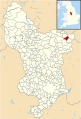 Derbyshire UK parish map highlighting Clowne.svg 888 × 1 308; 2,34 MB
-
 Disused Railway Line near the M1 Motorway - geograph.org.uk - 4016638.jpg 4 000 × 3 000; 3,01 MB
-
 East of Clowne - geograph.org.uk - 3900010.jpg 1 944 × 2 592; 1,62 MB
-
 Electricity sub station near Clowne - geograph.org.uk - 3551288.jpg 800 × 533; 99 KB
-
 Entering Clowne - geograph.org.uk - 4305133.jpg 640 × 480; 39 KB
-
 Entrance to Van Dyk Hotel ahead - geograph.org.uk - 4578659.jpg 640 × 335; 70 KB
-
 Farm bridge over M1 near Romeley Wood - geograph.org.uk - 4616500.jpg 1 600 × 1 067; 973 KB
-
 Farm Track Bridge across M1 near Barlborough - geograph.org.uk - 5894595.jpg 1 024 × 651; 98 KB
-
 Farm track south of Clowne - geograph.org.uk - 3058149.jpg 3 648 × 2 736; 4,85 MB
-
 Farm track to Romeley Hall Farm - geograph.org.uk - 2441289.jpg 950 × 713; 297 KB
-
 Farmland and hedgerow - geograph.org.uk - 4113586.jpg 640 × 480; 108 KB
-

-
 Field above Stanfree Cottage - geograph.org.uk - 2441280.jpg 950 × 713; 282 KB
-
 Field entrance off Mansfield Road - geograph.org.uk - 4113572.jpg 640 × 406; 92 KB
-
 Fields and Farmsteads near Clowne - geograph.org.uk - 4113693.jpg 4 000 × 3 000; 3,64 MB
-
 Fields and view to Clowne - geograph.org.uk - 2622063.jpg 1 024 × 736; 330 KB
-
 Fishing pond - geograph.org.uk - 6143987.jpg 640 × 480; 52 KB
-
 Footbridge over the M1 - geograph.org.uk - 4667440.jpg 640 × 426; 37 KB
-
 Footpath below Tesco distribution centre - geograph.org.uk - 2166070.jpg 718 × 900; 393 KB
-
 Footpath down to Stanfree - geograph.org.uk - 2441277.jpg 950 × 713; 266 KB
-
 Footpath near Ringing Villa Farm - geograph.org.uk - 4115556.jpg 4 000 × 3 000; 2,55 MB
-
 Footpath to Manor Farm - geograph.org.uk - 2853549.jpg 3 158 × 2 245; 1,24 MB
-
 Footpath towards Clowne - geograph.org.uk - 2441272.jpg 950 × 713; 318 KB
-
 Footpaths near Manor Farm - geograph.org.uk - 3058434.jpg 3 648 × 2 736; 4,79 MB
-
 Forgotten railway line - panoramio.jpg 1 944 × 2 592; 1,22 MB
-
 Gapsick Lane - geograph.org.uk - 3589846.jpg 1 142 × 857; 367 KB
-
 Gapsick Lane, Clowne - geograph.org.uk - 3547749.jpg 4 000 × 2 248; 4,13 MB
-
 Gapsick trig - geograph.org.uk - 3589850.jpg 857 × 1 142; 548 KB
-
 Garage on Creswell Road, Clowne - geograph.org.uk - 4305142.jpg 640 × 480; 56 KB
-
 Half a mile to junction 30 - geograph.org.uk - 4570272.jpg 640 × 382; 160 KB
-
 Harlesthorpe Dam - geograph.org.uk - 2746979.jpg 640 × 480; 84 KB
-
 Harlesthorpe dam.jpg 640 × 427; 136 KB
-
 Hedgerow beside Mansfield Road - geograph.org.uk - 4113576.jpg 640 × 480; 92 KB
-
 Hickingwood Lane - geograph.org.uk - 4754874.jpg 3 616 × 4 793; 4,67 MB
-
 Hickinwood Lane near Clowne - geograph.org.uk - 4459895.jpg 4 000 × 3 000; 2,22 MB
-
 Hilltop fields and path to Oxcroft - geograph.org.uk - 2441259.jpg 950 × 501; 197 KB
-
 Holiday Caravan for Rent - geograph.org.uk - 3900548.jpg 2 455 × 1 754; 1,43 MB
-
 Hollin hill bridge clowne - panoramio.jpg 2 592 × 1 944; 1,32 MB
-
 Hoodcroft, a farm near Barlborough - geograph.org.uk - 3058110.jpg 3 648 × 2 736; 5,12 MB
-
 Hotel Van Dyk, near Clowne - geograph.org.uk - 4303833.jpg 1 600 × 1 200; 424 KB
-
 House of Hair Creswell Road Clowne - geograph.org.uk - 1001155.jpg 640 × 470; 49 KB
-
 Houses in Creswell Road, Clowne - geograph.org.uk - 5670789.jpg 640 × 481; 64 KB
-
 Houses lining Barlborough Road - geograph.org.uk - 2166127.jpg 900 × 457; 236 KB
-
 Houses on Barlborough Road, New Barlborough - geograph.org.uk - 4754608.jpg 4 815 × 3 672; 4,41 MB
-
 Houses on Boughton Lane - geograph.org.uk - 4305160.jpg 640 × 480; 51 KB
-
 Houses over lightly snowed field - geograph.org.uk - 3366720.jpg 1 500 × 843; 1,37 MB
-

-
 Junction of Milking Lane and Low Road, Clowne - geograph.org.uk - 3900549.jpg 2 592 × 1 944; 3,18 MB
-
 Looking towards Clowne College - geograph.org.uk - 1334581.jpg 640 × 480; 80 KB
-
 Low road looking towards stanfree,nov 2010. - panoramio.jpg 4 153 × 1 671; 1,82 MB
-
 M1 heading north near Woodthorpe - geograph.org.uk - 2842869.jpg 640 × 480; 44 KB
-
 M1 northbound towards junction 30 - geograph.org.uk - 3855285.jpg 1 200 × 900; 285 KB
-
 Mansfield Road (B6417) - geograph.org.uk - 4113580.jpg 640 × 480; 110 KB
-
 Mansfield Road south of Clowne - geograph.org.uk - 2431232.jpg 950 × 616; 245 KB
-
 Mill Street, Clowne - geograph.org.uk - 2431224.jpg 950 × 666; 308 KB
-
 Nature claims back railway line - panoramio.jpg 2 592 × 1 944; 1,3 MB
-
 New Barlborough, outskirts of Clowne - geograph.org.uk - 3058449.jpg 3 648 × 2 736; 4,13 MB
-
 New build houses, open weekend - geograph.org.uk - 3058442.jpg 3 648 × 2 736; 4,03 MB
-
 Nice day for a wedding - geograph.org.uk - 1433898.jpg 640 × 431; 75 KB
-

-
 North Road, Clowne - geograph.org.uk - 2166151.jpg 900 × 603; 284 KB
-
 Northfields - geograph.org.uk - 3551498.jpg 800 × 533; 88 KB
-
 Northfields, a small road of distinction - geograph.org.uk - 2968991.jpg 3 648 × 2 736; 4,63 MB
-
 Oil seed rape, ripening - geograph.org.uk - 3058083.jpg 3 648 × 2 736; 5,09 MB
-
 Old station ,clowne south - panoramio.jpg 2 592 × 1 944; 1,17 MB
-

-
 Open fields towards Clowne - geograph.org.uk - 2441269.jpg 950 × 518; 180 KB
-
 Open space on Jago Avenue, Clowne - geograph.org.uk - 2746989.jpg 640 × 480; 41 KB
-
 Oxcroft Lane - geograph.org.uk - 4116180.jpg 640 × 480; 89 KB
-
 Oxcroft seen from Damsbrook Farm - geograph.org.uk - 4115683.jpg 4 000 × 3 000; 3,19 MB
-
 Ploughed Field near Stanfree - geograph.org.uk - 4113670.jpg 4 000 × 3 000; 2,88 MB
-
 Polytunnel and vegetables growing - geograph.org.uk - 2968919.jpg 3 648 × 2 736; 4,67 MB
-
 Ponies on the edge of Clowne - geograph.org.uk - 3058133.jpg 3 648 × 2 736; 4,83 MB
-
 Poppys at southgate,clowne - panoramio.jpg 3 888 × 2 592; 5,66 MB
-
 Potato crop, New Barlborough - geograph.org.uk - 4305150.jpg 640 × 433; 52 KB
-
 Beighton, Clown, Langwith, Shirebrook RJD 134.jpg 1 888 × 2 826; 676 KB
-
 Ramper Avenue - geograph.org.uk - 3058356.jpg 3 648 × 2 736; 4,68 MB
-
 Reduced to rubble - geograph.org.uk - 2968997.jpg 3 648 × 2 736; 4,82 MB
-
 Road Bridge over Disused Railway Line in Clowne - geograph.org.uk - 2853541.jpg 3 274 × 2 442; 1,36 MB
-
 Roadside sculpture in Clowne - geograph.org.uk - 2430333.jpg 713 × 950; 340 KB
-
 Roadside Triangulation Pillar near Clowne - geograph.org.uk - 845439.jpg 640 × 480; 117 KB
-
 Sheffield Road, Clowne - geograph.org.uk - 3547752.jpg 4 000 × 2 248; 4,19 MB
-
 Shops and Ashlea Club - geograph.org.uk - 1001156.jpg 640 × 480; 51 KB
-
 Silent rails - panoramio.jpg 2 592 × 3 888; 5,77 MB
-
 Site of Oxcroft Colliery seen from Disused Railway - geograph.org.uk - 4021419.jpg 3 896 × 2 860; 2,23 MB
-
 Slayley Lane - View heading Downhill - geograph.org.uk - 1050251.jpg 640 × 480; 119 KB
-
 Small paddock by Boughton Lane, Clowne - geograph.org.uk - 2431213.jpg 950 × 512; 236 KB
-
 Stanfree cottage - geograph.org.uk - 6146816.jpg 640 × 480; 71 KB
-
 Stile by Milking Lane, Clowne - geograph.org.uk - 3900550.jpg 1 944 × 2 592; 2,78 MB
-
 Sub station on Gapsick Lane - geograph.org.uk - 1001158.jpg 640 × 480; 84 KB
-
 Terraced houses on King Street, Clowne - geograph.org.uk - 3900558.jpg 1 850 × 2 590; 1,65 MB
-

-
 Terraced houses, North Road, Clowne - geograph.org.uk - 2166155.jpg 900 × 638; 319 KB
-

-
 Terraced housing, Clowne - geograph.org.uk - 4305135.jpg 640 × 480; 49 KB
-
 The bridge nr clowne craggs - panoramio.jpg 1 944 × 2 592; 1,22 MB
-
 The old boathouse by Harlesthorpe Dam - geograph.org.uk - 4754846.jpg 5 184 × 3 888; 5,96 MB
-
 The Old Rectory , Clowne (7638210316).jpg 4 000 × 2 664; 2,34 MB
-
 The south end of Boughton Lane, Clowne - geograph.org.uk - 2431219.jpg 950 × 502; 243 KB
-
 The Travellers Rest, Clowne - geograph.org.uk - 4305137.jpg 640 × 441; 56 KB
-
 Tree on the corner of Hickingwood Lane - geograph.org.uk - 2746995.jpg 480 × 640; 110 KB
-
 Triangulation pillar by Hickingwood Lane - geograph.org.uk - 4754596.jpg 5 184 × 3 888; 6,06 MB
-
 Trig Point - geograph.org.uk - 119426.jpg 640 × 427; 114 KB
-
 Trig point east of Hickingwood Farm - geograph.org.uk - 3058414.jpg 3 648 × 2 736; 4,67 MB
-
 Van Dyck's Garden Centre and Hotel - geograph.org.uk - 645019.jpg 640 × 480; 53 KB
-
 Van Dyk Hotel - geograph.org.uk - 814779.jpg 640 × 480; 83 KB
-
 Van Dyk Hotel on Worksop Road - geograph.org.uk - 4325140.jpg 640 × 362; 68 KB
-
 View to Ringer Villa Farm from Border Lane - geograph.org.uk - 3900027.jpg 2 407 × 1 806; 1,63 MB
-
 Viewpoint westwards - geograph.org.uk - 2441264.jpg 950 × 542; 249 KB
-
 Wheatfield east of Hickingwood Farm - geograph.org.uk - 3589851.jpg 1 142 × 857; 439 KB
-
 Wild flower meadow and view west from Clowne - geograph.org.uk - 3058140.jpg 3 648 × 2 736; 4,79 MB
-
 A very muddy Slayley Lane - geograph.org.uk - 1050242.jpg 640 × 480; 137 KB
-

-
 Clowne - Approaching Low Road Nursery - geograph.org.uk - 702610.jpg 640 × 480; 74 KB
-
 Clowne street view - geograph.org.uk - 1433889.jpg 640 × 427; 60 KB
-
 Damsbrook Lane Field - geograph.org.uk - 123404.jpg 640 × 480; 115 KB
-
 Footpath to Shuttlewood - geograph.org.uk - 151251.jpg 640 × 480; 127 KB
-
 Former Railway Creswell - geograph.org.uk - 115090.jpg 640 × 427; 84 KB
-
 Manor Farm, Clowne - geograph.org.uk - 302916.jpg 640 × 433; 63 KB
-
 Markland Grips - geograph.org.uk - 177160.jpg 640 × 480; 128 KB
-

-
 Oxcroft Disposal Point on Mill Lane - geograph.org.uk - 702592.jpg 640 × 480; 74 KB


.jpg)


_-_geograph.org.uk_-_702619.jpg)


.jpg)
.jpg)
.jpg)
.jpg)


.jpg)


_-_geograph.org.uk_-_4305138.jpg)


_-_geograph.org.uk_-_4113580.jpg)


_-_geograph.org.uk_-_4305146.jpg)


.jpg)


_-_geograph.org.uk_-_702575.jpg)
