Category:Clutha River / Mata-Au
Zur Navigation springen
Zur Suche springen

Fluss in Neuseeland   | |||||
| Medium hochladen | |||||
| Ist ein(e) | |||||
|---|---|---|---|---|---|
| Ort | |||||
| Länge |
| ||||
| Mündet in | |||||
| Anrainerstaat | |||||
| Nebenfluss |
| ||||
 | |||||
Unterkategorien
Es werden 11 von insgesamt 11 Unterkategorien in dieser Kategorie angezeigt:
In Klammern die Anzahl der enthaltenen Kategorien (K), Seiten (S), Dateien (D)
A
B
- Balclutha Bridge (6 D)
C
- Clyde Dam (24 D)
E
- Earnscleugh Bridge (1 D)
J
- James Horn Bridge (4 D)
L
- Lake Dunstan (26 D)
M
- Millers Flat Bridge (2 D)
R
- The Red Bridge (New Zealand) (2 D)
- Roxburgh Dam (6 D)
T
- Tuapeka Mouth Punt and Jetty (1 D)
Medien in der Kategorie „Clutha River / Mata-Au“
Folgende 30 Dateien sind in dieser Kategorie, von 30 insgesamt.
-
 Alexandra autumn colours, Otago, South Island, New Zealand.jpg 4.032 × 3.024; 3,77 MB
-
 Beaumont, New Zealand aerial photo 2006.jpg 1.327 × 932; 529 KB
-
 Beaumont, New Zealand bridge over the Clutha River.jpg 2.048 × 1.536; 2,71 MB
-
 Beaumont, South Island, NZ.jpg 4.032 × 3.024; 6,19 MB
-
 Clutha Floods 1948 (22560820675).jpg 1.453 × 1.725; 1,11 MB
-
 Clutha from Kaitangata.jpg 4.608 × 3.456; 3,3 MB
-
 Clutha River at Albert Town.jpg 800 × 411; 91 KB
-
 Clutha River Floods (1995) (23100454154).jpg 4.212 × 1.484; 3,32 MB
-
 Clutha River near Albert Town 01.jpg 4.080 × 938; 3,11 MB
-
 Clutha River near Albert Town 02.jpg 3.946 × 1.294; 3,87 MB
-
 Clutha River, Otago, New Zealand, 1968.jpg 1.800 × 1.200; 489 KB
-
 Clutha River, Roxburgh, New Zealand.jpg 1.536 × 2.048; 2,87 MB
-
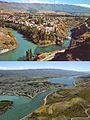 Cromwell Junction Before and After the Clyde dam.jpg 435 × 580; 130 KB
-
 Cromwell New Zealand banner.jpg 5.950 × 850; 3,45 MB
-
 Cromwell New Zealand October 2013.JPG 6.016 × 4.000; 9,73 MB
-
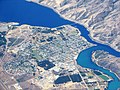 Cromwell NZ aerial.JPG 2.592 × 1.944; 4,73 MB
-
 Crookston Survey District.jpg 3.938 × 3.948; 5,24 MB
-
 Crossing the Clutha (47817026742).jpg 1.920 × 1.025; 1,96 MB
-
 Looking East Along The Clutha River.jpg 1.600 × 1.200; 429 KB
-
 NZ-Clutha R.png 1.234 × 1.395; 233 KB
-
 On the Clutha River at Albert Town.jpg 1.500 × 1.011; 418 KB
-
 OT 136 - Pomahaka Survey District.jpg 3.539 × 4.155; 3,98 MB
-
 Panorama of Clyde, Otago, New Zealand.jpg 1.437 × 653; 800 KB
-
 Red Bridge across the Clutha River at Luggate.jpg 1.904 × 1.259; 389 KB
-
 Report on the geology and gold fields of Otago (Plate I A) BHL43691812.jpg 2.528 × 1.642; 666 KB
-
 Roxburgh Bridge (32925084947).jpg 1.778 × 1.200; 1,72 MB
-
 Roxburgh, New Zealand new bridge.jpg 2.048 × 1.536; 2,98 MB
-
 RoxburghBridge.jpg 1.536 × 1.152; 1,37 MB
-
 Upper Clutha Valley.jpg 1.931 × 1.270; 459 KB
-
 William Williams on a railway jigger, rabbit hunting in Otago, ca 1900 (3056669963).jpg 4.959 × 3.807; 5,07 MB


.jpg)


.jpg)


_BHL43691812.jpg)
.jpg)


.jpg)
_(23100454154).jpg)