Category:Compton Pauncefoot
Aller à la navigation
Aller à la recherche
localité britannique du comté anglais de Somerset  | |||||
| Téléverser des médias | |||||
| Nature de l’élément | |||||
|---|---|---|---|---|---|
| Lieu | South Somerset, Somerset, Angleterre du Sud-Ouest, Angleterre | ||||
 | |||||
English: category for files related to the village of Compton Pauncefoot in Somerset.
Sous-catégories
Cette catégorie comprend 3 sous-catégories, dont les 3 ci-dessous.
B
M
Média dans la catégorie « Compton Pauncefoot »
Cette catégorie comprend 68 fichiers, dont les 68 ci-dessous.
-
 A lane near Lower Woolston - geograph.org.uk - 3366319.jpg 2 592 × 1 944 ; 1,41 Mio
-
 A lodge for Compton Castle - geograph.org.uk - 3366333.jpg 2 592 × 1 944 ; 1,82 Mio
-
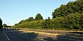
 A303 approaching Knoll Hill - geograph.org.uk - 4044628.jpg 640 × 363 ; 42 kio
-
 A303 at Maperton Ridge - geograph.org.uk - 4057183.jpg 640 × 342 ; 79 kio
-
 A303 eastbound - geograph.org.uk - 3770726.jpg 2 023 × 1 287 ; 1,33 Mio
-
 A303 heading west - geograph.org.uk - 6260777.jpg 1 024 × 684 ; 185 kio
-
 A303 heading west - geograph.org.uk - 6260791.jpg 1 024 × 684 ; 192 kio
-
 A303 near Compton Pauncefoot - geograph.org.uk - 5871614.jpg 4 106 × 2 089 ; 1,37 Mio
-
 A303 near Compton Pauncefoot - geograph.org.uk - 5871687.jpg 4 266 × 2 094 ; 988 kio
-
 A303 north of East Hall Farm - geograph.org.uk - 3845036.jpg 3 648 × 2 736 ; 1,28 Mio
-
 A303 north of Warren Hill - geograph.org.uk - 3845110.jpg 3 648 × 2 736 ; 1,69 Mio
-
 A303 parking area ahead - geograph.org.uk - 3770722.jpg 1 600 × 1 044 ; 334 kio
-
 A303 towards Compton Pauncefoot - geograph.org.uk - 3763286.jpg 1 600 × 1 024 ; 293 kio
-
 A303, eastbound - geograph.org.uk - 4780102.jpg 640 × 395 ; 51 kio
-
 A303, Knole Hill - geograph.org.uk - 3024514.jpg 640 × 368 ; 40 kio
-
 A303, Maperton Ridge - geograph.org.uk - 5301397.jpg 640 × 425 ; 59 kio
-
 A303, Warren Hill - geograph.org.uk - 5301408.jpg 640 × 396 ; 52 kio
-
 A303, westbound - geograph.org.uk - 4753503.jpg 640 × 389 ; 31 kio
-
 A303, westbound - geograph.org.uk - 5301398.jpg 640 × 407 ; 51 kio
-
 A303, westbound - geograph.org.uk - 5301405.jpg 640 × 441 ; 51 kio
-
 Across the A303 near Compton Pauncefoot - geograph.org.uk - 5871676.jpg 4 277 × 2 517 ; 1,58 Mio
-
 Barrow Hill from the A303 - geograph.org.uk - 3024464.jpg 640 × 370 ; 28 kio
-
 Barrow Hill south of A303 - geograph.org.uk - 3538329.jpg 1 024 × 511 ; 56 kio
-
 Blackford, St. Michael's Church - geograph.org.uk - 4677928.jpg 4 124 × 2 408 ; 5,13 Mio
-
 Blackford, St. Michael's Church - geograph.org.uk - 4677931.jpg 3 650 × 2 409 ; 5,24 Mio
-
 Blackford, St. Michael's Church - geograph.org.uk - 4677937.jpg 3 672 × 2 441 ; 6,52 Mio
-
 Blackford, St. Michael's Church, West tower doorway - geograph.org.uk - 4677944.jpg 3 720 × 3 604 ; 7,56 Mio
-
 Clump of trees - geograph.org.uk - 5366874.jpg 640 × 426 ; 42 kio
-
 Compton Castle, Devon - geograph.org.uk - 1997646.jpg 800 × 539 ; 114 kio
-
 Compton Pauncefoot turning - geograph.org.uk - 5301400.jpg 640 × 426 ; 76 kio
-
 Compton Pauncefoot, by the mill - geograph.org.uk - 2968295.jpg 640 × 427 ; 368 kio
-
 Compton Pauncefoot, by Warren Hill - geograph.org.uk - 2968283.jpg 640 × 427 ; 398 kio
-
 Compton Pauncefoot, Downyard - geograph.org.uk - 2968274.jpg 640 × 427 ; 384 kio
-
 Compton Pauncefoot, edge of the village - geograph.org.uk - 2968270.jpg 640 × 427 ; 456 kio
-
-
 Compton Pauncefoot, nearing a stile - geograph.org.uk - 2968288.jpg 640 × 427 ; 506 kio
-
 Compton Pauncefoot, stile - geograph.org.uk - 2968291.jpg 640 × 427 ; 514 kio
-
 Compton Pauncefoot, towards the mill - geograph.org.uk - 2968280.jpg 640 × 427 ; 457 kio
-
 Comptonpauncefootoldrectory.jpg 640 × 480 ; 178 kio
-
 Crossing the A 303(T) where the footpath should be - geograph.org.uk - 6107988.jpg 4 608 × 2 592 ; 5,65 Mio
-
 Crossroad by the church in Blackford - geograph.org.uk - 5407356.jpg 640 × 427 ; 109 kio
-
 Field on the edge of Old Wood - geograph.org.uk - 5407686.jpg 640 × 427 ; 83 kio
-
 Foggy A303 - geograph.org.uk - 4745610.jpg 640 × 393 ; 14 kio
-
 Footpath near Blackford - geograph.org.uk - 2276303.jpg 640 × 480 ; 78 kio
-
 Footpath to Compton Paucefoot - geograph.org.uk - 2276353.jpg 640 × 480 ; 106 kio
-
 Footpath to Compton Paucefoot - geograph.org.uk - 2276379.jpg 640 × 480 ; 73 kio
-
 In Compton Pauncefoot village - geograph.org.uk - 4929671.jpg 2 592 × 1 944 ; 1,01 Mio
-
 Lay by near Warren Hill - geograph.org.uk - 4044614.jpg 640 × 374 ; 58 kio
-
 Lay-by by A303 near Compton Pauncefoot - geograph.org.uk - 3545953.jpg 1 024 × 768 ; 100 kio
-
 Molehills near Blackford - geograph.org.uk - 2276343.jpg 640 × 480 ; 71 kio
-
 Mrs Best's Holiday Cottage - geograph.org.uk - 6107977.jpg 4 608 × 2 592 ; 7,26 Mio
-
 Near Blackford - geograph.org.uk - 306414.jpg 640 × 480 ; 129 kio
-
 Old Direction Sign - Signpost by Blackford Crossroads - geograph.org.uk - 6072371.jpg 1 360 × 1 913 ; 261 kio
-
 Ordnance Survey Cut Mark - geograph.org.uk - 3375722.jpg 4 000 × 3 000 ; 4,82 Mio
-
 Road to Yarlington - geograph.org.uk - 5301399.jpg 640 × 426 ; 56 kio
-
 Shallow cutting for A303 on Knoll Hill - geograph.org.uk - 3545967.jpg 1 024 × 768 ; 98 kio
-
 South Somerset , The A303 - geograph.org.uk - 3127010.jpg 4 288 × 2 848 ; 5,51 Mio
-
 St Michael's Church, Blackford - geograph.org.uk - 5407361.jpg 640 × 427 ; 97 kio
-
-

-
 The lane to Compton Pauncefoot - geograph.org.uk - 4929664.jpg 2 592 × 1 944 ; 1,45 Mio
-
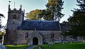
 Compton Pauncefoot - the approach to the Church - geograph.org.uk - 420910.jpg 640 × 480 ; 196 kio
-
 Fields by Woolston road - geograph.org.uk - 560828.jpg 640 × 425 ; 89 kio
-
 Gathered in for the winter - geograph.org.uk - 560835.jpg 640 × 425 ; 94 kio
-
 Ploughed field hillside - geograph.org.uk - 560876.jpg 640 × 425 ; 81 kio
-
 The Crescent, Compton Pauncefoot - geograph.org.uk - 476484.jpg 640 × 480 ; 114 kio
-
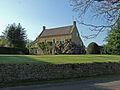
 The Old Rectory, Compton Pauncefoot - geograph.org.uk - 476467.jpg 640 × 480 ; 123 kio
-
 Woolston Manor Farmhouse - geograph.org.uk - 424307.jpg 640 × 446 ; 172 kio


_where_the_footpath_should_be_-_geograph.org.uk_-_6107988.jpg)


_-_geograph.org.uk_-_420934.jpg)


