Category:Cook Strait
Zur Navigation springen
Zur Suche springen
Meerenge zwischen der Nord- und Südinsel Neuseelands  | |||||
| Medium hochladen | |||||
| Ist ein(e) | |||||
|---|---|---|---|---|---|
| Benannt nach | |||||
| Ort |
| ||||
| Höhe über dem Meeresspiegel |
| ||||
| Zufluss |
| ||||
 | |||||
Unterkategorien
Es werden 9 von insgesamt 9 Unterkategorien in dieser Kategorie angezeigt:
In Klammern die Anzahl der enthaltenen Kategorien (K), Seiten (S), Dateien (D)
B
E
- East Head (Arapaoa) (1 D)
I
L
M
- Monte Stello (ship, 1979) (3 D)
P
S
- Sinclair Head (23 D)
T
- Thoms Rock (2 D)
Medien in der Kategorie „Cook Strait“
Folgende 94 Dateien sind in dieser Kategorie, von 94 insgesamt.
-
 20110928 WN S1015660 0018.jpg - Flickr - NZ Defence Force.jpg 3.799 × 2.533; 6,14 MB
-
 20110928 WN S1015660 0022 - Flickr - NZ Defence Force.jpg 3.885 × 2.589; 4,73 MB
-
-
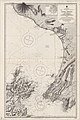
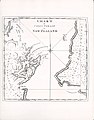
 Admiralty Chart No 2588 Plans on the South West Coast of North Island, Published 1925.jpg 11.915 × 8.180; 27,56 MB
-
-
-

-
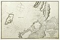
 Admiralty Chart No 2684 Cook Strait Anchorages Sheet 1, Published 1859.jpg 12.741 × 8.545; 15,93 MB
-
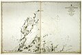
 Admiralty Chart No 2685 Cook Strait Anchorages Sheet 2, Published 1859.jpg 7.433 × 5.092; 9,31 MB
-
 Arahura 2004Livery.jpg 3.701 × 2.395; 4,28 MB
-
 Aranui roll-on roll-off ferry.jpg 2.156 × 1.242; 255 KB
-

-
 Bulk carrier in Cook Strait, New Zealand, 28 October 2005.jpg 3.264 × 2.176; 4,23 MB
-
 Captain Cook's Voyages - Illustrations (19).jpg 900 × 1.152; 211 KB
-

-

-
 Coast of Marlborough Region from Cook Strait 01.jpg 2.938 × 1.540; 3,24 MB
-
 Coast of Marlborough Region from Cook Strait 02.jpg 2.728 × 1.602; 3,48 MB
-
 Coast of Wellington Region from Cook Strait.jpg 3.753 × 2.324; 4,24 MB
-
 Cook Strait (New Zealand) North View.jpg 2.048 × 1.024; 1,62 MB
-
 Cook Strait (New Zealand).jpg 1.022 × 690; 757 KB
-
 Cook Strait and Marlborough Sounds from Mount Kaukau.jpg 2.708 × 1.912; 5,18 MB
-
 Cook Strait and Marlborough Sounds, New Zealand, looking southeast (ISS015-E-10737).jpg 3.032 × 2.008; 766 KB
-
 Cook Strait and the Kaikouras from Southgate, Wellington, New Zealand, 21 August 2005.jpg 3.264 × 2.176; 4,78 MB
-
 Cook Strait from Melrose, Wellington.jpg 3.264 × 2.176; 6,21 MB
-
 Cook Strait with Rimutaka Range.jpg 1.152 × 1.536; 853 KB
-
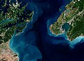
 Cook Strait, New Zealand (MODIS 2019-06-06).jpg 2.082 × 1.573; 1,01 MB
-
 Cook Strait, New Zealand (MODIS 2021-07-10).jpg 3.403 × 2.780; 1,57 MB
-
 Cook Strait, New Zealand 12 September 2005 (42608237).jpg 3.264 × 2.176; 4,08 MB
-
 Cook Strait.jpg 666 × 475; 86 KB
-
 Cook Streight accountofvoyages 02hawk 0484.jpg 2.543 × 2.493; 662 KB
-
 Cookov prolaz, Aotearoa.jpg 5.152 × 3.864; 4,26 MB
-
 Cookov prolaz, Novi Zeland.jpg 5.152 × 3.864; 4,88 MB
-
 Cookov prolaz.jpg 5.152 × 3.864; 4,29 MB
-
 Cookstraitferry.jpg 701 × 361; 68 KB
-
 Dappled Cook Strait, New Zealand, 1 April 2011 - Flickr - PhillipC.jpg 3.810 × 2.367; 1,87 MB
-
 Earth from Space- Cook Strait, New Zealand ESA24912671.jpg 5.007 × 3.666; 15,3 MB
-
 Earth from Space- Cook Strait, New Zealand ESA24912671.tiff 10.013 × 7.331; 122,59 MB
-
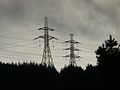 Electricity transmission lines in New Zealand.jpg 1.024 × 768; 211 KB
-
 Emerald Hours in New Zealand (1906) · Lowth · 117.jpg 1.522 × 2.113; 254 KB
-
 Entrance to Tory Channel 01.jpg 3.369 × 2.246; 3,52 MB
-
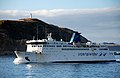
 Ferry Near Welly Heads Towards Picton.jpg 2.200 × 1.200; 1,39 MB
-
 Framed Ocean (27161038125).jpg 1.600 × 1.200; 543 KB
-
 From North Island to South Island, New Zealand - panoramio.jpg 1.600 × 1.200; 298 KB
-
 HMNZS Otago - Flickr - NZ Defence Force.jpg 1.800 × 1.201; 327 KB
-
 HMNZS Te Kaha - Flickr - NZ Defence Force.jpg 1.800 × 1.201; 290 KB
-
 HodgesA View of Cape Stephens in Cook's Straits New Zealand with Waterspout 1776..jpg 2.500 × 1.768; 298 KB
-
 IslandBayPICT4959.jpg 1.024 × 768; 201 KB
-
 ISS eye view of Shuttle docking.jpg 3.032 × 2.064; 1,82 MB
-
 ISS-40 South end of New Zealand's North Island.jpg 4.256 × 2.832; 1,13 MB
-
 ISS-42 New Zealand in Sunglint, annotated.jpg 720 × 480; 159 KB
-
 ISS-42 New Zealand in Sunglint, large resolution.jpg 4.928 × 3.280; 1,84 MB
-
 Kaiteriteri beach.jpg 800 × 600; 89 KB
-
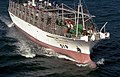 Long liner in Cook Strait, New Zealand 1988.jpg 1.106 × 706; 1,17 MB
-

-

-

-
-
 Navy fleet concentration in the Cook Strait - Flickr - NZ Defence Force (1).jpg 1.800 × 1.201; 205 KB
-
 Navy fleet concentration in the Cook Strait - Flickr - NZ Defence Force (2).jpg 1.800 × 1.200; 296 KB
-
 Navy fleet concentration in the Cook Strait - Flickr - NZ Defence Force.jpg 1.800 × 1.200; 288 KB
-
 Nicholas Chevalier - Cook Strait, New Zealand - Google Art Project.jpg 5.087 × 2.537; 3,69 MB
-
 Nicholas Chevalier - Near Paekakariki, Cook Strait - Google Art Project.jpg 5.089 × 3.451; 4,51 MB
-
 NZ Wahine Salvage 02.jpg 1.524 × 920; 116 KB
-
 NZ Wahine Salvage.jpg 1.396 × 768; 97 KB
-
 Palliser Bay and Cook Strait, looking east (ISS015-E-10738).jpg 3.032 × 2.008; 892 KB
-
 Pano.DétroitCook.jpg 1.000 × 472; 89 KB
-
 Paraparaumu from Hemi Matenga Park, Waikanae.jpg 1.024 × 768; 394 KB
-
 Picton Rail Ferry Ramp.jpg 640 × 480; 235 KB
-
 Sheep in the Hold (26556633093).jpg 1.529 × 1.146; 853 KB
-
 South coast of Wellington 05.jpg 3.631 × 905; 2,49 MB
-
 South coast of Wellington 06.jpg 2.849 × 1.062; 2,42 MB
-
 South coast of Wellington 07.jpg 2.902 × 1.258; 2,49 MB
-
 South coast of Wellington 08.jpg 2.833 × 1.151; 2,87 MB
-
 South coast of Wellington 09.jpg 2.956 × 1.592; 4,4 MB
-
 South coast of Wellington 10.jpg 3.001 × 814; 2,32 MB
-
 South coast of Wellington 11.jpg 2.973 × 1.084; 2,2 MB
-
 South coast of Wellington 12.jpg 4.550 × 2.056; 5,11 MB
-
 South coast of Wellington 13.jpg 4.483 × 1.923; 4,97 MB
-
 South coast of Wellington 14.jpg 3.879 × 1.465; 3,08 MB
-
 South coast of Wellington 15.jpg 3.772 × 448; 1,15 MB
-
 South coast of Wellington 16.jpg 3.000 × 2.000; 6,34 MB
-
 South coast of Wellington 17.jpg 2.949 × 1.966; 6,24 MB
-
 South from Kapiti.jpg 2.272 × 1.704; 534 KB
-
 Southern Coast of the North Island (26777936616).jpg 1.600 × 1.200; 417 KB
-
 StraitShipping-SantaRegina.jpg 865 × 651; 99 KB
-
 STS-116 spacewalk 1.jpg 3.032 × 2.000; 2,01 MB
-
-
 Thoms Rock in the Cook Strait.jpg 2.944 × 566; 1,32 MB
-
 Tongue Point and Terawhiti Station wind farm from Cook Strait.jpg 3.840 × 2.160; 2,15 MB
-
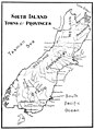
 Wairau River Map.jpg 400 × 340; 77 KB
-
 Waves crashing at Moa Point with Inland Kaikoura Range in the distance.jpg 6.200 × 3.600; 8,47 MB
-

-
 Wellington-Picton 83,6km - na obzoru Jižní ostrov NZ, Cookův průliv - panoramio.jpg 2.027 × 1.525; 1,82 MB


,_Published_1858.jpg)
,_Published_1859.jpg)


.jpg)
.jpg)
.jpg)


_North_View.jpg)
.jpg)
.jpg)


.jpg)
.jpg)
.jpg)


_%C2%B7_Lowth_%C2%B7_117.jpg)


.jpg)


.jpg)
.jpg)


.jpg)


.jpg)


.jpg)


_(14775451543).jpg)


