Category:Corneilla-de-Conflent
Zur Navigation springen
Zur Suche springen
English: Corneilla-de-Conflent (département of Pyrénées-Orientales, Languedoc-Roussillon région, France)
Français : Corneilla-de-Conflent (Pyrénées-Orientales, Languedoc-Roussillon, France)
französische Gemeinde   | |||||
| Medium hochladen | |||||
| Aussprache (Audiodatei) | |||||
|---|---|---|---|---|---|
| Ist ein(e) | |||||
| Ort |
| ||||
| Amtssprache |
| ||||
| Leiter der Regierung oder Verwaltung |
| ||||
| Einwohnerzahl |
| ||||
| Fläche |
| ||||
| offizielle Website | |||||
 | |||||
Unterkategorien
Es werden 7 von insgesamt 7 Unterkategorien in dieser Kategorie angezeigt:
In Klammern die Anzahl der enthaltenen Kategorien (K), Seiten (S), Dateien (D)
Medien in der Kategorie „Corneilla-de-Conflent“
Folgende 37 Dateien sind in dieser Kategorie, von 37 insgesamt.
-
 13.307.PNRPyrénées Catalanes - Vue sur Corneilla-de-Conflent et la vallée de la Têt.jpg 4.132 × 2.755; 6,71 MB
-
 66057-Corneilla-de-Conflent-Routes-Hydro.png 3.507 × 2.480; 858 KB
-
 66057-Corneilla-de-Conflent-Sols.png 3.270 × 2.598; 1,78 MB
-
 Ambouillas arriere.jpg 600 × 406; 57 KB
-
 Ambouillas cabane berger.jpg 600 × 402; 84 KB
-
 Ambouillas facade.jpg 403 × 600; 84 KB
-
 Ambouillas gouttereau aval.jpg 600 × 396; 52 KB
-
 Ambouillas nef a.jpg 402 × 600; 62 KB
-
 Ambouillas plafond longitudinal.jpg 600 × 403; 67 KB
-
 Ancienne voie ferrée Corneilla-de-Conflent.jpg 4.000 × 3.000; 5,05 MB
-
 CANIGO DESDE CORNELLA DE CONFLENT - panoramio.jpg 4.288 × 2.848; 5,5 MB
-
 Carrière Badabany - marbre rouge.jpg 2.967 × 2.353; 3,39 MB
-
 Cheminée Mas Forge Corneilla-de-Conflent.jpg 1.804 × 1.354; 2,43 MB
-
 Corneilla-de-Conflent et le Pic du Canigou.jpg 4.608 × 3.456; 3,6 MB
-
 Corneilla-de-Conflent, fontaine93.jpg 2.304 × 3.456; 3,9 MB
-
 Cornellà de Conflent 1812.png 750 × 480; 691 KB
-
 Cupule dolmen de Coberturat.jpg 2.931 × 2.296; 5,65 MB
-
 Dolmen Coberturat et Canigou.jpg 3.264 × 2.448; 1,28 MB
-
 Dolmen Serrat d'En Parot.jpg 1.000 × 750; 215 KB
-
 ETH-BIB-Moräne oberhalb Corneilla (vom Cannigou), Pyrenäen-Dia 247-02107.tif 3.534 × 2.820; 9,59 MB
-
 ETH-BIB-Talkgrube Corneilla von Westen, Pyrenäen-Dia 247-02098.tif 3.404 × 2.794; 9,16 MB
-
 ETH-BIB-Talkgrube Corneilla, mit Mt. Cannigou, Pyrenäen-Dia 247-02101.tif 3.641 × 2.811; 9,84 MB
-
 ETH-BIB-Talkgrube Corneilla, Talk-Sortiererei, Pyrenäen-Dia 247-02097.tif 3.427 × 2.820; 9,31 MB
-
 ETH-BIB-Talkgrube Corneilla, Westhälfte, Pyrenäen-Dia 247-02100.tif 2.920 × 3.499; 9,84 MB
-
 ETH-BIB-Talkgrube Corneilla, Westhälfte-Dia 247-02104.tif 3.591 × 2.740; 9,48 MB
-
 Localització de Cornellà de Conflent respecte del Conflent.svg 428 × 323; 239 KB
-
 Map commune FR insee code 66057.png 756 × 605; 78 KB
-
 Monfreid, Corneilla de Conflent.jpg 902 × 1.228; 339 KB
-
 Plaça amb una font i un carrer de Cornellà de Conflent.jpeg 1.024 × 509; 83 KB
-
 Plaça d'un poble amb una font i una persona.jpeg 1.024 × 516; 94 KB
-
 Pont Saint-Pierre et chemin de fer Villefranche-de-Conflent.jpg 4.608 × 3.456; 8,95 MB
-
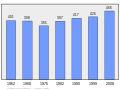 Population - Municipality code 66057.svg 475 × 355; 13 KB
-

-

-
 Tronçon de l'ancienne voie ferrée minérale, Corneilla-de-Conflent.jpg 3.000 × 2.259; 7,68 MB
-
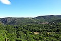 Vue vers l'est en direction du village de Corneilla-de-Conflent.jpg 4.168 × 2.834; 3,22 MB
-
 À l'ancienne raffinerie de minerai de fer, Corneilla-de-Conflent.jpg 3.000 × 2.250; 8,06 MB


_Roussillon_(1912)_(14772993195).jpg)


