Category:Cratons
Przejdź do nawigacji
Przejdź do wyszukiwania
日本語: クラトン
najstarsza, utwardzona część skorupy ziemskiej  | |||||
| Prześlij plik multimedialny | |||||
| Podklasa dla | |||||
|---|---|---|---|---|---|
| Część | |||||
| Składa się z |
| ||||
| |||||
Podkategorie
Poniżej wyświetlono 13 spośród wszystkich 13 podkategorii tej kategorii.
*
B
C
D
- Dharwar Craton (11 plików)
G
H
- Hearne Craton (2 pliki)
K
- Kaapvaal Craton (16 plików)
L
P
S
W
Y
Pliki w kategorii „Cratons”
Poniżej wyświetlono 65 spośród wszystkich 65 plików w tej kategorii.
-
 Argeiesekratons.svg 600 × 400; 483 KB
-
 Cratone.JPG 650 × 373; 85 KB
-
 Cratons ES.svg 2000 × 1364; 266 KB
-
 Cratons IT.svg 2000 × 1364; 269 KB
-
 Cratons JA.svg 2000 × 1364; 268 KB
-
 Cratons NL.svg 2000 × 1364; 283 KB
-
De-Kraton.ogg 1,8 s; 17 KB
-
 USGS Arabian-Nubian Shield Terranes.png 713 × 771; 205 KB
-
 Arabian-Nubian Shield-fr.svg 1181 × 1494; 49 KB
-
 Arabian-Nubian Shield.svg 1181 × 1494; 49 KB
-
 Australia cratons EN.svg 5430 × 4287; 75 KB
-
 Australian cratons NL.svg 5430 × 4287; 91 KB
-
 Australian rock ages-MJC.png 800 × 676; 18 KB
-
 Avalonia Baltica geologi.png 949 × 898; 737 KB
-
 Avalonia Baltica Sarmatia geologi.png 949 × 901; 850 KB
-
-
 Borgmassivet, Antarkritka.jpg 1567 × 829; 1,24 MB
-
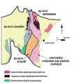
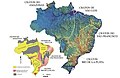 Cratons brasileiros.jpg 425 × 275; 27 KB
-
 Cratons d afrique australe.svg 360 × 247; 49 KB
-
 Cratons West Gondwana and EAO v2.png 629 × 599; 157 KB
-
 Cratons West Gondwana and EAO.png 629 × 599; 153 KB
-
 Cratons West Gondwana IT.svg 745 × 710; 170 KB
-
 Cratons West Gondwana-es.svg 745 × 710; 196 KB
-
 Cratons West Gondwana.svg 745 × 710; 170 KB
-
 CRB-Yellowstone mantle plume model.jpg 3789 × 4069; 1,84 MB
-
 Cráton do São Francisco Bahia.png 314 × 355; 86 KB
-
 Distribution of crustal domains in the East African Orogen.jpg 377 × 790; 132 KB
-
 Esboço geológico de parte do norte-nordeste brasileiro.png 928 × 491; 358 KB
-
 Estrutura de um cráton.jpg 882 × 453; 96 KB
-
 Tectonic Map of Grawler Craton.gif 1084 × 1415; 70 KB
-
 Geological domain of Superior Craton.pdf 4166 × 4166; 776 KB
-
 Geological domains of Superior Craton.png 5556 × 5556; 1,33 MB
-
 Geology of Kimberley (Western Australia) Overview Map.png 937 × 870; 188 KB
-
 Grouse Creek block location1.jpg 1131 × 1206; 565 KB
-
 Hypothesis 1 v3.png 456 × 945; 205 KB
-
 Kimberlite Pipes in Africa.png 680 × 608; 74 KB
-
 Location of qinling.png 793 × 570; 28 KB
-
 Location of the Eastern Block of North China Craton.jpg 645 × 569; 174 KB
-
 Mapa geológico simplificado do Cráton São Luís.png 793 × 826; 606 KB
-

-
 Mawson Kraton.png 1139 × 2173; 198 KB
-
 Model noah.png 867 × 789; 480 KB
-
 Neuschwabenland Geo.jpg 2308 × 1864; 611 KB
-
 North america and scandinavia basement rocks.png 484 × 429; 15 KB
-
 North america basement rocks.png 484 × 429; 31 KB
-
 North america craton nps.gif 512 × 599; 32 KB
-
 North American provinces and orogens.PNG 497 × 583; 237 KB
-
 China map with craton and tectonic elements .png 1800 × 1263; 214 KB
-

-
 Chino-Korean craton location.jpg 512 × 532; 199 KB
-
 Kusky Phanerozoic North China Craton model .png 1032 × 1667; 203 KB
-
 North China Craton Map.png 1800 × 1263; 132 KB
-
 Permian North China Craton.png 1184 × 538; 82 KB
-
 Saharan Metacraton-fr.svg 489 × 423; 84 KB
-
 Saharan Metacraton.svg 489 × 423; 83 KB
-
 Siberiakratonet.jpg 374 × 284; 58 KB
-
 Siberian craton location.jpg 512 × 437; 139 KB
-
 Sibiria craton NO.jpg 377 × 272; 28 KB
-
 A Map of South China Craton.png 1446 × 1071; 423 KB
-
 Yangtse craton location.jpg 512 × 532; 200 KB
-
 Southern African Cratons.svg 360 × 247; 49 KB
-
 Ukraine geology (de).png 1239 × 847; 450 KB
-
 West African Craton.svg 361 × 357; 165 KB
-

-
 螢幕擷取畫面 (35).png 767 × 644; 65 KB


_Overview_Map.png)


.png)

.PNG)
.png)