Category:Creise
Zur Navigation springen
Zur Suche springen
Berg im Vereinigten Königreich  | |||||
| Medium hochladen | |||||
| Ist ein(e) | |||||
|---|---|---|---|---|---|
| Ort | Highland, Highlands, Schottland | ||||
| Gebirgszug | |||||
| Schartenhöhe |
| ||||
| Höhe über dem Meeresspiegel |
| ||||
| Bezugsberg | |||||
 | |||||
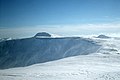
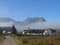
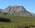
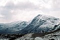
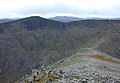
Creise is a mountain that stands at the eastern end of Glen Coe in Scotland. It is just to the south east of the River Etive, some 26 kilometres South-southeast of Fort William in the Highland Council area. The mountain was previously known as Clach Leathad (Stony Slope) in the Munro Tables prior to 1981, its name being changed to Creise when the highest point was found to be 1200 metres further north along the summit ridge when using new mapping techniques.
Medien in der Kategorie „Creise“
Folgende 25 Dateien sind in dieser Kategorie, von 25 insgesamt.
-
 130707 Creise.jpg 3.264 × 2.060; 1,85 MB
-
 Ben Nevis from Glen Coe - geograph.org.uk - 243136.jpg 640 × 427; 52 KB
-
 Black Corries road - geograph.org.uk - 1352671.jpg 640 × 360; 82 KB
-
 Buachaille Etive Mor - geograph.org.uk - 43354.jpg 640 × 480; 60 KB
-
 Buachaille Etive Mòr from Creise.jpg 1.991 × 1.416; 237 KB
-
 Creise , Munro No 50 - geograph.org.uk - 506516.jpg 640 × 480; 107 KB
-
 Creise and Meall a Bhuiridh from the SE.jpg 1.860 × 1.269; 230 KB
-
 Creise from River Coupall - geograph.org.uk - 40139.jpg 640 × 406; 67 KB
-
 Glen Etive Entices (14312715212).jpg 6.016 × 4.016; 9,45 MB
-
 Kings House Hotel - geograph.org.uk - 1352636.jpg 640 × 449; 80 KB
-
 Kings House Hotel.jpg 1.920 × 900; 337 KB
-
-
 Rannoch Moor from Creise - geograph.org.uk - 241634.jpg 640 × 427; 69 KB
-
 Sron na Criese behind the Kings House - geograph.org.uk - 102177.jpg 640 × 480; 52 KB
-
 Sròn na Crèise - geograph.org.uk - 1533688.jpg 640 × 513; 99 KB
-
 Stob a Ghlas Choire - geograph.org.uk - 752976.jpg 640 × 426; 49 KB
-
 Stron na Creise - geograph.org.uk - 369350.jpg 640 × 447; 90 KB
-
 View down the Cam Ghleann - geograph.org.uk - 627407.jpg 800 × 506; 232 KB
-
 View from Beinn a Chrulaiste - geograph.org.uk - 317575.jpg 640 × 428; 58 KB
-
 View north from Stob a' Choire Odhair - geograph.org.uk - 638345.jpg 800 × 600; 248 KB
-
 View south from Creise - geograph.org.uk - 627411.jpg 800 × 600; 210 KB
-
 West Highland Way 2005 Coe.jpg 1.840 × 1.232; 290 KB
-
 West of Meall a' Bhuiridh - geograph.org.uk - 627402.jpg 640 × 444; 91 KB
-
 Creise - geograph.org.uk - 72774.jpg 640 × 480; 81 KB
-
 View from Creise - geograph.org.uk - 136260.jpg 640 × 480; 105 KB


.jpg)


