Category:Creswell, Staffordshire
Aller à la navigation
Aller à la recherche
English: Creswell is a small village on the north-western edge of Stafford, the county town of Staffordshire, England situated on elevated ground above the wide floodplain and extensive marshes of the River Sow.
village britannique  | |||||
| Téléverser des médias | |||||
| Nature de l’élément | |||||
|---|---|---|---|---|---|
| Lieu | Stafford, Staffordshire, Midlands de l'Ouest, Angleterre | ||||
| Population |
| ||||
 | |||||
Sous-catégories
Cette catégorie comprend seulement la sous-catégorie ci-dessous.
C
- Creswell Church Ruin (2 F)
Média dans la catégorie « Creswell, Staffordshire »
Cette catégorie comprend 86 fichiers, dont les 86 ci-dessous.
-
 A34 Stone Road - geograph.org.uk - 1964031.jpg 640 × 480 ; 39 kio
-
 A34 Stone Road - geograph.org.uk - 6049340.jpg 800 × 533 ; 494 kio
-
 A5013 Creswell Grove near M6 junction - geograph.org.uk - 1964013.jpg 640 × 480 ; 51 kio
-
 A5013 to Eccleshall - geograph.org.uk - 259816.jpg 427 × 640 ; 70 kio
-

-
 Approach to the M6 at Creswell - geograph.org.uk - 5752996.jpg 1 600 × 900 ; 258 kio
-
 Beaconside-Marston Lane junction - geograph.org.uk - 2147531.jpg 640 × 480 ; 92 kio
-
 Bridge over M6 near Great Bridgeford - geograph.org.uk - 4458379.jpg 640 × 427 ; 207 kio
-
 Car showroom on Mustang Drive Business Park - geograph.org.uk - 3666747.jpg 3 872 × 2 592 ; 2,65 Mio
-
 Closed footpath by the A34 - geograph.org.uk - 3666789.jpg 3 872 × 2 592 ; 3,91 Mio
-
 Creswell , M6 Motorway - geograph.org.uk - 6284999.jpg 6 000 × 4 000 ; 4,53 Mio
-
 Creswell , M6 Motorway - geograph.org.uk - 6285002.jpg 6 000 × 4 000 ; 5,71 Mio
-
 Creswell , M6 Motorway - geograph.org.uk - 6285003.jpg 6 000 × 4 000 ; 4,18 Mio
-
 Creswell , M6 Motorway Roadside - geograph.org.uk - 6284997.jpg 6 000 × 4 000 ; 4,68 Mio
-
 Creswell Farm on the A5013 - geograph.org.uk - 2557658.jpg 640 × 428 ; 66 kio
-
 Creswell Grove (A5013) - geograph.org.uk - 6259833.jpg 800 × 600 ; 78 kio
-
 Creswell Grove off the A5013 near Stafford - geograph.org.uk - 2557673.jpg 640 × 428 ; 65 kio
-
 Creswell Grove, Stafford - geograph.org.uk - 6263119.jpg 5 184 × 3 888 ; 4,4 Mio
-
 Elizabeth II postbox on Creswell Grove, Stafford - geograph.org.uk - 6263118.jpg 3 204 × 4 586 ; 3,89 Mio
-
 Farmland near Creswell - geograph.org.uk - 1077391.jpg 640 × 457 ; 161 kio
-
 Flooding, River Sow - geograph.org.uk - 3323773.jpg 640 × 430 ; 41 kio
-
 Flooding, River Sow - geograph.org.uk - 3323781.jpg 640 × 415 ; 36 kio
-
 Floodplain of the River Sow - geograph.org.uk - 3668731.jpg 640 × 367 ; 30 kio
-
 Footbridge over the M6 - geograph.org.uk - 2651038.jpg 640 × 237 ; 33 kio
-
 Footpath to heaven - geograph.org.uk - 6259831.jpg 800 × 600 ; 124 kio
-
 Grazing off Creswell Grove (A5013) - geograph.org.uk - 6259828.jpg 800 × 600 ; 89 kio
-
 Houses in Wilkes Wood - geograph.org.uk - 5752990.jpg 1 600 × 900 ; 257 kio
-
 Houses on Creswell Grove - geograph.org.uk - 6259825.jpg 800 × 489 ; 74 kio
-
 Hurricane Close, Stafford Audi - geograph.org.uk - 6049461.jpg 800 × 533 ; 531 kio
-
 In the Sow Valley - geograph.org.uk - 3668727.jpg 640 × 357 ; 28 kio
-
 Iron Mountain by the M6 - geograph.org.uk - 2651044.jpg 640 × 430 ; 52 kio
-
 Iron Mountain from M6 North - geograph.org.uk - 2105583.jpg 640 × 384 ; 313 kio
-
 Junction 14 M6 motorway near Stafford - geograph.org.uk - 3003220.jpg 1 024 × 636 ; 108 kio
-
 Looking down A34 towards M6 Junction 14 - geograph.org.uk - 2511508.jpg 640 × 428 ; 63 kio
-
 M6 - geograph.org.uk - 3668713.jpg 640 × 311 ; 33 kio
-
 M6 Access Bridge, Trinity Fields - geograph.org.uk - 3527474.jpg 640 × 480 ; 382 kio
-
 M6 approaching Junction 14 - geograph.org.uk - 3690099.jpg 3 636 × 1 747 ; 1,59 Mio
-
 M6 crossing a flooded River Sow - geograph.org.uk - 3323783.jpg 640 × 394 ; 35 kio
-
 M6 crossing the A34 - geograph.org.uk - 6304948.jpg 1 024 × 576 ; 69 kio
-
 M6 in the Sow Valley - geograph.org.uk - 3839976.jpg 640 × 430 ; 37 kio
-

-

-
 M6 Motorway at junction 14 - geograph.org.uk - 2244667.jpg 640 × 480 ; 50 kio
-
 M6 Motorway bridge, Junction 14 - geograph.org.uk - 6259823.jpg 800 × 600 ; 79 kio
-
 M6 Motorway east of Great Bridgeford - geograph.org.uk - 2244677.jpg 640 × 480 ; 53 kio
-
 M6 motorway embankment near Stafford - geograph.org.uk - 4199696.jpg 1 024 × 768 ; 93 kio
-
 M6 motorway in cutting near Creswell Grove - geograph.org.uk - 2244672.jpg 640 × 480 ; 52 kio
-
 M6 Motorway north of Rowe's Wood - geograph.org.uk - 2244676.jpg 640 × 480 ; 45 kio
-
 M6 Motorway passing Iron Mountain - geograph.org.uk - 2244668.jpg 640 × 480 ; 48 kio
-
 M6 near Great Bridgeford - geograph.org.uk - 4531829.jpg 640 × 427 ; 222 kio
-
 M6 north of Junction 14 - geograph.org.uk - 2651034.jpg 640 × 430 ; 53 kio
-
 M6 north of Junction 14 - geograph.org.uk - 2651041.jpg 640 × 430 ; 49 kio
-
 M6 south near New Plantation - geograph.org.uk - 2824796.jpg 640 × 481 ; 44 kio
-
 M6, Doxey Marshes - geograph.org.uk - 3715091.jpg 640 × 351 ; 28 kio
-
 Marston Lane - geograph.org.uk - 6621516.jpg 1 280 × 851 ; 1,44 Mio
-
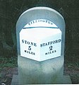 Milestone, Creswell.jpg 710 × 761 ; 175 kio
-
 Motels and Restaurants, Primepoint 14, Stafford - geograph.org.uk - 897742.jpg 640 × 448 ; 126 kio
-
 Mustang Drive - geograph.org.uk - 3666827.jpg 3 872 × 2 592 ; 2,77 Mio
-
 Mustang Drive Business Park - geograph.org.uk - 3666719.jpg 3 872 × 2 592 ; 3,12 Mio
-
 Mustang Drive Business Park - geograph.org.uk - 3666736.jpg 3 872 × 2 592 ; 3,67 Mio
-
 New Housing Development off the A513 - geograph.org.uk - 4028232.jpg 2 880 × 1 714 ; 2,28 Mio
-
 New industrial units, Stafford - geograph.org.uk - 897720.jpg 640 × 457 ; 155 kio
-
 Northbound M6 Approaching Junction 14 - geograph.org.uk - 3527468.jpg 640 × 480 ; 395 kio
-
 Pedestrian-controlled Traffic Lights on the A34 - geograph.org.uk - 6049156.jpg 1 024 × 768 ; 989 kio
-
 Premier Inn, Stafford North - geograph.org.uk - 3666701.jpg 3 872 × 2 592 ; 3,29 Mio
-
 Primepoint 14, Stafford - geograph.org.uk - 897735.jpg 640 × 457 ; 135 kio
-

-
 Roundabout on Mustang Drive - geograph.org.uk - 3666740.jpg 3 872 × 2 592 ; 2,54 Mio
-
 Rowe's Wood, Creswell - geograph.org.uk - 259809.jpg 427 × 640 ; 89 kio
-
 Shackleton Way, Stafford - geograph.org.uk - 6620642.jpg 1 280 × 851 ; 1,25 Mio
-
 Spot the River Sow - geograph.org.uk - 3323770.jpg 640 × 384 ; 39 kio
-
 Stafford District , Grassy Field ^ Tree - geograph.org.uk - 3725000.jpg 4 288 × 2 848 ; 4,63 Mio
-
 Stafford District , Railway Line - geograph.org.uk - 3724985.jpg 4 288 × 2 848 ; 4,81 Mio
-
 Stafford District , Railway Line ^ Grassy Field - geograph.org.uk - 3724989.jpg 4 288 × 2 848 ; 4,93 Mio
-
 Stafford District , Tillington Drain - geograph.org.uk - 3724992.jpg 4 288 × 2 848 ; 5,25 Mio
-
 Stafford District , Wetlands - geograph.org.uk - 3724998.jpg 3 623 × 2 362 ; 4,43 Mio
-
 Taylor Wimpey Marston Grange Development - geograph.org.uk - 6621432.jpg 1 280 × 851 ; 1,38 Mio
-
 The M6 at Junction 14 - geograph.org.uk - 3382132.jpg 3 392 × 1 996 ; 1,26 Mio
-
 The M6 passes industrial units on Mustang Drive - geograph.org.uk - 4576533.jpg 1 500 × 980 ; 132 kio
-
 The Perrin Memorial - geograph.org.uk - 3666729.jpg 3 872 × 2 592 ; 4,24 Mio
-
 The Shire Horse - geograph.org.uk - 6049280.jpg 1 024 × 765 ; 721 kio
-
 The Shire Horse, Stafford - geograph.org.uk - 3666774.jpg 3 872 × 2 592 ; 3,44 Mio
-
 The Shire Horse, Stafford - geograph.org.uk - 6049462.jpg 800 × 533 ; 522 kio
-
 The Shire Horse, Stafford - geograph.org.uk - 6621347.jpg 1 280 × 851 ; 1,29 Mio
-
 The Sow Valley - geograph.org.uk - 3839971.jpg 640 × 430 ; 39 kio
-
 Wilkes Wood - geograph.org.uk - 2821230.jpg 640 × 356 ; 40 kio


_-_geograph.org.uk_-_6259833.jpg)


_-_geograph.org.uk_-_6259828.jpg)


