Category:Crosby Ravensworth
Vai alla navigazione
Vai alla ricerca

village in Cumbria, England, UK  | |||||
| Carica un file multimediale | |||||
| Istanza di | |||||
|---|---|---|---|---|---|
| Luogo | Eden, Cumbria, Nord Ovest dell'Inghilterra, Inghilterra | ||||
 | |||||
English: Crosby Ravensworth is the name of a village, a civil parish and a fell in the Eden district of Cumbria, England. The village is about four miles east of the M6 motorway, and Shap.
Sottocategorie
Questa categoria contiene le 10 sottocategorie indicate di seguito, su un totale di 10.
D
- Dalebanks Beck Ford (3 F)
F
- Flass House (7 F)
H
- High Whitber Ford (2 F)
M
- Maulds Meaburn (31 F)
O
- Oddendale (17 F)
R
- Reagill (13 F)
- Reagill Grange (3 F)
S
File nella categoria "Crosby Ravensworth"
Questa categoria contiene 200 file, indicati di seguito, su un totale di 739.
(pagina precedente) (pagina successiva)-
 'God is always there' - geograph.org.uk - 2402536.jpg 480 × 640; 183 KB
-

-
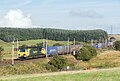
 390137 at Salterwath - July 2016 - geograph.org.uk - 5019518.jpg 1 250 × 884; 715 KB
-
 70006 at Salterwath - August 2016 - geograph.org.uk - 5095247.jpg 1 250 × 845; 971 KB
-
 A gap in the trees at Potrigg - geograph.org.uk - 6250550.jpg 5 184 × 3 888; 4,69 MB
-
 A road to Appleby - geograph.org.uk - 5876788.jpg 1 024 × 683; 333 KB
-
 Access Land^ - geograph.org.uk - 6242343.jpg 1 024 × 1 024; 437 KB
-
 Allan's Ling Wood - geograph.org.uk - 5858777.jpg 1 024 × 685; 402 KB
-
 An alien shore, Hardendale Quarry - geograph.org.uk - 2461689.jpg 768 × 1 024; 252 KB
-
 An interesting drystone wall - geograph.org.uk - 6248187.jpg 5 184 × 3 888; 5,49 MB
-
 Ancient cairn on Gaythorne Plain - geograph.org.uk - 5179892.jpg 1 024 × 683; 779 KB
-
-
 Animal feeder on Maulds Meaburn Moor - geograph.org.uk - 5935955.jpg 1 024 × 768; 178 KB
-

-
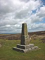
 Approaching Ravensworth Fell Trig Point - geograph.org.uk - 4124818.jpg 2 560 × 1 920; 2,57 MB
-
 Approaching Robin Hood's Grave - geograph.org.uk - 3495082.jpg 640 × 425; 338 KB
-
 Arched doorway, Gaythorne Hall - geograph.org.uk - 4539989.jpg 640 × 480; 134 KB
-
 Ash and erratic, Crosby Ravensworth Fell - geograph.org.uk - 6243138.jpg 1 024 × 1 024; 403 KB
-
 Ashes off Gilts Lane - geograph.org.uk - 3395997.jpg 640 × 360; 222 KB
-
 B6260 and a grassy path - geograph.org.uk - 5231417.jpg 1 024 × 683; 304 KB
-
 B6260 at Bridgedale Brow - geograph.org.uk - 4597574.jpg 1 024 × 683; 246 KB
-
 B6260 at Raise Howe - geograph.org.uk - 6233424.jpg 640 × 480; 57 KB
-
 B6260 heading north across Maulds Meaburn Moor - geograph.org.uk - 5935953.jpg 1 024 × 768; 151 KB
-
 B6260, Bank Moor - geograph.org.uk - 3664110.jpg 640 × 480; 69 KB
-
 B6260, Orton Fells - geograph.org.uk - 4958849.jpg 1 024 × 683; 297 KB
-
 B6260, wide verges - geograph.org.uk - 5858779.jpg 1 024 × 685; 362 KB
-
 B6261 road after passing under M6 - geograph.org.uk - 2410850.jpg 640 × 480; 67 KB
-
 B6261 road to Orton - geograph.org.uk - 2421522.jpg 640 × 480; 80 KB
-
 Back down the track to Haber - geograph.org.uk - 3134034.jpg 3 264 × 2 448; 1,8 MB
-
 Banger racing circuit - geograph.org.uk - 2009538.jpg 640 × 480; 58 KB
-
 Bank Head - geograph.org.uk - 1635592.jpg 640 × 427; 43 KB
-
 Bank Lane - geograph.org.uk - 1635607.jpg 640 × 427; 73 KB
-
 Bank Lane - geograph.org.uk - 1635613.jpg 640 × 427; 68 KB
-
 Barn and large erratic at Cow Green - geograph.org.uk - 6264020.jpg 5 184 × 3 888; 5,54 MB
-
 Barn and tree at Broadslack - geograph.org.uk - 2462677.jpg 1 024 × 768; 131 KB
-
 Barn below Prickly Bank Wood - geograph.org.uk - 2576951.jpg 640 × 480; 153 KB
-

-
 Barn conversion at Littlebeck - geograph.org.uk - 6229937.jpg 640 × 480; 70 KB
-
 Barn or cottage near Scar Quarry - geograph.org.uk - 6229139.jpg 640 × 480; 119 KB
-
 Beacon Hill - geograph.org.uk - 929938.jpg 640 × 480; 66 KB
-
 Beacon Hill, Orton - geograph.org.uk - 4958857.jpg 1 024 × 683; 419 KB
-
 Beech hedge near Seat Hill - geograph.org.uk - 1021933.jpg 640 × 480; 115 KB
-
 Behind Meaburn Hall - geograph.org.uk - 5859248.jpg 1 024 × 685; 307 KB
-
 Bell Foot - geograph.org.uk - 1635578.jpg 640 × 427; 106 KB
-
 Bench mark on barn, Crosby Ravensworth - geograph.org.uk - 2402541.jpg 640 × 480; 144 KB
-

-
 Bench mark on the Galloway Stone - geograph.org.uk - 2459850.jpg 480 × 640; 162 KB
-
 Benchmark on Mauds Meaburn Moor trig point - geograph.org.uk - 4597581.jpg 683 × 1 024; 308 KB
-

-
 Benchmark on stone at wall junction - geograph.org.uk - 4536470.jpg 683 × 1 024; 262 KB
-

-

-
 Bend on the lane from High Whitber to Littlebeck - geograph.org.uk - 5299680.jpg 1 024 × 768; 135 KB
-
 Beside Harding's Wood - geograph.org.uk - 4535369.jpg 640 × 480; 108 KB
-
 Between Harberwain and Haber - geograph.org.uk - 1885037.jpg 1 600 × 900; 272 KB
-
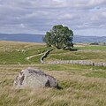
 Big tree on Crosby Ravensworth Fell - geograph.org.uk - 4515491.jpg 800 × 600; 196 KB
-
 Bird trap, Crosby Ravensworth Fell - geograph.org.uk - 2400297.jpg 480 × 640; 134 KB
-
 Black Dub - geograph.org.uk - 179644.jpg 338 × 450; 129 KB
-
 Black Dub - geograph.org.uk - 6242617.jpg 1 024 × 576; 257 KB
-
-
 BlackDub.JPG 1 280 × 960; 629 KB
-
 Blea Beck - geograph.org.uk - 2399769.jpg 480 × 640; 111 KB
-
 Blea Beck - geograph.org.uk - 6243145.jpg 1 024 × 576; 241 KB
-
 Boulders by Blind Beck - geograph.org.uk - 2403841.jpg 800 × 600; 170 KB
-
 Boulders, Crosby Ravensworth Moor - geograph.org.uk - 3275995.jpg 640 × 480; 291 KB
-
 Boundary Stone and Bridleway Fingerpost - geograph.org.uk - 3132812.jpg 2 448 × 3 264; 1,88 MB
-
 Boundary stone and cattle grid at Orton Scar - geograph.org.uk - 5905902.jpg 1 620 × 1 126; 224 KB
-
 Bousfield Howe - geograph.org.uk - 2464126.jpg 640 × 480; 84 KB
-
 Brackenslack Cottage - geograph.org.uk - 6230488.jpg 1 024 × 768; 137 KB
-
 Brackenslack service reservoir - geograph.org.uk - 6230484.jpg 1 024 × 768; 156 KB
-
 Bridge and chestnut tree, Maulds Meaburn - geograph.org.uk - 2577217.jpg 640 × 480; 129 KB
-
 Bridge and gate on the lane to Gaythorne Hall - geograph.org.uk - 5897459.jpg 1 600 × 1 200; 486 KB
-
 Bridge over Dalebanks Beck - geograph.org.uk - 2401389.jpg 640 × 480; 157 KB
-
 Bridge over river Maulds Meaburn - geograph.org.uk - 4035419.jpg 1 024 × 768; 224 KB
-
 Bridge over the Lyvennet, Maulds Meaburn - geograph.org.uk - 4218798.jpg 1 024 × 678; 274 KB
-
 Bridleway approaching High Dalebanks - geograph.org.uk - 2402523.jpg 640 × 480; 132 KB
-
 Bridleway at Bank Head - geograph.org.uk - 3495149.jpg 640 × 425; 316 KB
-
 Bridleway by Harding's Wood - geograph.org.uk - 2009515.jpg 640 × 480; 61 KB
-
 Bridleway descending from Gaythorne Plain - geograph.org.uk - 5897470.jpg 1 600 × 1 200; 526 KB
-
 Bridleway on Gaythorne Plain - geograph.org.uk - 5897466.jpg 1 600 × 1 200; 515 KB
-
 Bridleway to Crosby Ravensworth - geograph.org.uk - 3027929.jpg 4 320 × 3 240; 4,58 MB
-
 Bridleway to Crosby Ravensworth - geograph.org.uk - 6248177.jpg 5 184 × 3 888; 6,37 MB
-
 Bridleway to Drybeck - geograph.org.uk - 3495232.jpg 640 × 425; 305 KB
-
 Bridleway to High Dalebanks - geograph.org.uk - 6248184.jpg 5 146 × 3 422; 3,6 MB
-
 Bridleway towards Coalpit Hill - geograph.org.uk - 5897462.jpg 1 600 × 1 200; 503 KB
-
 Bronze Age round cairn on Gaythorne Plain - geograph.org.uk - 6244299.jpg 5 184 × 3 888; 5,31 MB
-
 Bus shelter, Maulds Meaburn - geograph.org.uk - 6229858.jpg 640 × 480; 80 KB
-
 By Broadslack Plantation - geograph.org.uk - 5960258.jpg 1 024 × 683; 296 KB
-
 Cairn - geograph.org.uk - 1885044.jpg 1 600 × 1 068; 346 KB
-
 Cairn at Wicker Street - geograph.org.uk - 6258619.jpg 5 184 × 3 888; 4,61 MB
-
 Cairn circle - geograph.org.uk - 1885050.jpg 1 600 × 1 068; 325 KB
-
 Cairn circle near Oddendale - geograph.org.uk - 5757547.jpg 1 024 × 768; 221 KB
-
 Cairn circle, Oddendale - geograph.org.uk - 2400485.jpg 800 × 600; 187 KB
-
 Cairn on Crosby Ravensworth Fell - geograph.org.uk - 4278841.jpg 1 500 × 957; 1,1 MB
-
 Cairn on Crosby Ravensworth Fell - geograph.org.uk - 6244307.jpg 5 184 × 3 888; 5,57 MB
-
 Cairn on Crosby Ravensworth Fell - geograph.org.uk - 6256433.jpg 4 707 × 3 285; 2,15 MB
-
 Cairn south of Oddendale - geograph.org.uk - 6250548.jpg 5 184 × 3 888; 3,8 MB
-
 Cairn, Coalpit Hill - geograph.org.uk - 5067245.jpg 1 920 × 1 280; 556 KB
-
 Cairn, Crosby Ravensworth Fell - geograph.org.uk - 2400334.jpg 640 × 480; 121 KB
-
 Cairn, Crosby Ravensworth Fell - geograph.org.uk - 6242621.jpg 1 024 × 576; 168 KB
-
 Cairn, Howenook Pike - geograph.org.uk - 5067277.jpg 1 920 × 1 280; 537 KB
-
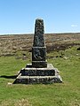
 Carved head on the Black Dub Monument - geograph.org.uk - 4515634.jpg 640 × 480; 134 KB
-
 Carved lion on the Black Dub Monument - geograph.org.uk - 4515648.jpg 640 × 480; 172 KB
-
 Castlehouse Scar Plantation - geograph.org.uk - 989245.jpg 640 × 480; 90 KB
-
 Castlehowe Scar Stone Circle, Shap - geograph.org.uk - 5513263.jpg 640 × 480; 108 KB
-
 Castlehowe stone circle - geograph.org.uk - 6255000.jpg 640 × 480; 182 KB
-

-
 Cattle above Wyebourne Farm - geograph.org.uk - 6229215.jpg 640 × 480; 75 KB
-
 Cattle grazing near Castlehowe Scar farm - geograph.org.uk - 5933833.jpg 1 024 × 768; 239 KB
-
 Cattle grazing near Wintertarn - geograph.org.uk - 2459642.jpg 640 × 480; 79 KB
-
 Cattle Grid at Bell Foot - geograph.org.uk - 3495168.jpg 640 × 425; 345 KB
-
 Cattle grid at Linglow Hill - geograph.org.uk - 6234156.jpg 640 × 480; 65 KB
-
 Cattle grid at Linglow Hill - geograph.org.uk - 6234161.jpg 640 × 480; 69 KB
-
 Cattle grid at Orton Scar - geograph.org.uk - 6230726.jpg 808 × 606; 90 KB
-

-

-

-
 Cattle near Shap - geograph.org.uk - 5960198.jpg 1 024 × 683; 251 KB
-

-
 Cleared boulders - geograph.org.uk - 6243167.jpg 1 024 × 576; 270 KB
-
 Clearfell, Wyegill Plantation - geograph.org.uk - 6065417.jpg 1 024 × 683; 277 KB
-
 Coalpit Hill the B6260 toward Orton - geograph.org.uk - 3132790.jpg 3 264 × 2 448; 1,71 MB
-
 Conifer plantation - geograph.org.uk - 3027841.jpg 1 600 × 1 200; 384 KB
-
 Conifer plantation, east of Flass House - geograph.org.uk - 5935947.jpg 1 024 × 768; 243 KB
-
 Coronation tree and limestone pavement on Crosby Fell - geograph.org.uk - 2274854.jpg 2 560 × 1 920; 2,67 MB
-
 Cows and laithe near Crosby Ravensworth - geograph.org.uk - 6230594.jpg 1 024 × 768; 123 KB
-
 Cows and tree, Castlehowe Scar - geograph.org.uk - 2459628.jpg 640 × 480; 79 KB
-
 Crake Trees - geograph.org.uk - 1635653.jpg 420 × 640; 71 KB
-
 Crake Trees - geograph.org.uk - 2576782.jpg 640 × 480; 75 KB
-
 Crake Trees ruin.jpg 640 × 431; 149 KB
-
 Crosby Ravensworth - geograph.org.uk - 3396008.jpg 640 × 360; 239 KB
-

-

-
 Crosby Ravensworth Fell - geograph.org.uk - 6242613.jpg 1 024 × 576; 285 KB
-
 Crosby Ravensworth Fell - geograph.org.uk - 6242615.jpg 1 024 × 576; 276 KB
-
 Crosby Ravensworth Fell - geograph.org.uk - 6242618.jpg 1 024 × 576; 210 KB
-
 Crosby Ravensworth Fell - geograph.org.uk - 6243140.jpg 1 024 × 576; 149 KB
-
 Crosby Ravensworth Fell - geograph.org.uk - 6243171.jpg 1 024 × 576; 205 KB
-
 Crosby Ravensworth Fell - geograph.org.uk - 6243893.jpg 1 024 × 576; 305 KB
-
 Crosby Ravensworth Fell - geograph.org.uk - 6243904.jpg 1 024 × 576; 185 KB
-
 Crosby Ravensworth Fell - geograph.org.uk - 6243908.jpg 1 024 × 576; 204 KB
-
 Crosby Ravensworth Fell - geograph.org.uk - 6243909.jpg 1 024 × 576; 279 KB
-
 Crosby Ravensworth Fell trig point - geograph.org.uk - 6256424.jpg 5 184 × 3 888; 4,33 MB
-
 Crosby Ravensworth Hall - geograph.org.uk - 6230646.jpg 1 024 × 768; 126 KB
-
 Crosby Ravensworth Methodist church - geograph.org.uk - 6230660.jpg 768 × 768; 165 KB
-
 Crosby Ravensworth, Cumbria, St Lawrence - geograph.org.uk - 5904030.jpg 4 608 × 3 456; 4,02 MB
-
 Crossing stiles near Crake Trees - geograph.org.uk - 4217881.jpg 1 024 × 721; 186 KB
-
 Crossroads on Gaythorne Plain - geograph.org.uk - 3495284.jpg 640 × 425; 358 KB
-
 Cumbrian signpost at a 326 metre spot height - geograph.org.uk - 5934046.jpg 1 024 × 768; 146 KB
-
 Cyclists on Morland Bank - geograph.org.uk - 6229660.jpg 480 × 640; 78 KB
-
 Dalebanks beck valley - geograph.org.uk - 854226.jpg 640 × 480; 63 KB
-
 Dalebanks Bridge ^ Fish Pass - geograph.org.uk - 1894898.jpg 600 × 450; 94 KB
-

-

-
 Dina Gill - geograph.org.uk - 6230724.jpg 1 024 × 768; 197 KB
-
 Disused Quarry Bank Moor - geograph.org.uk - 3132816.jpg 3 264 × 2 448; 1,67 MB
-
 Disused Quarry, Bank Moor - geograph.org.uk - 3664107.jpg 640 × 480; 79 KB
-
 Ditch and wall beside the B6260 - geograph.org.uk - 6234144.jpg 640 × 480; 82 KB
-
 Double rainbow, Crosby Ravensworth - geograph.org.uk - 2401405.jpg 640 × 443; 59 KB
-
 Down toward Crosby Ravensworth - geograph.org.uk - 3132848.jpg 3 264 × 2 448; 1,65 MB
-
 Dry stone wall above Hardendale Quarry - geograph.org.uk - 3027830.jpg 4 320 × 3 240; 4,59 MB
-
 Dry stone wall and tree - geograph.org.uk - 2404038.jpg 800 × 600; 170 KB
-
 Dry stone wall corner - geograph.org.uk - 3027865.jpg 4 320 × 3 240; 4,88 MB
-
 Dry stone walls alongside B6260 - geograph.org.uk - 5007960.jpg 1 500 × 832; 985 KB
-
 Dry valley, north of Crosby Ravensworth - geograph.org.uk - 5935920.jpg 1 024 × 768; 275 KB
-

-
 Duck and ducklings, Crosby Ravensworth - geograph.org.uk - 2402530.jpg 800 × 600; 272 KB
-
 Dyke corner, Crosby Ravensworth - geograph.org.uk - 6243161.jpg 1 024 × 576; 198 KB
-
 Dyke, Beacon Hill - geograph.org.uk - 4958891.jpg 1 024 × 576; 280 KB
-
 East from Crosby Ravensworth Fell - geograph.org.uk - 6256447.jpg 5 049 × 3 675; 2,75 MB
-
 Edge of Harberwain Plantation - geograph.org.uk - 3027821.jpg 4 320 × 3 240; 4,75 MB
-
 Edge of small plantation - geograph.org.uk - 3027839.jpg 4 320 × 3 240; 4,73 MB
-
 Edge of the common - geograph.org.uk - 4717052.jpg 1 024 × 576; 353 KB
-
 Edge of the common - geograph.org.uk - 6243175.jpg 1 024 × 576; 268 KB
-
 Enclosure at Potrigg - geograph.org.uk - 4278858.jpg 1 500 × 968; 1,44 MB
-
 Enclosure, Crosby Ravensworth Fell - geograph.org.uk - 6242625.jpg 1 024 × 576; 199 KB
-
 Enclosure, Crosby Ravensworth Fell - geograph.org.uk - 6243126.jpg 1 024 × 576; 234 KB
-
 Entering Oddendale - geograph.org.uk - 6248179.jpg 5 150 × 3 479; 3,61 MB
-
 Entrance into Castlehowe Scar plantation - geograph.org.uk - 5933842.jpg 1 024 × 768; 360 KB
-
 Entrance to the Village Hall, Crosby Ravensworth - geograph.org.uk - 4217812.jpg 1 024 × 678; 257 KB
-
 Erratic boulder, Crosby Ravensworth Fell - geograph.org.uk - 2207213.jpg 640 × 480; 116 KB
-
 Erratic boulders^ by Blind Beck - geograph.org.uk - 2990188.jpg 1 600 × 1 198; 462 KB
-
 Erratic on the Pavement - geograph.org.uk - 5067269.jpg 1 920 × 1 280; 556 KB
-
 Erratic, Oddendale - geograph.org.uk - 6243895.jpg 1 024 × 1 024; 542 KB
-
 Et in Arcadia ego - geograph.org.uk - 4538622.jpg 800 × 600; 159 KB
-
 Ewe Locks settlement site - detail - geograph.org.uk - 6264028.jpg 5 184 × 3 888; 5,31 MB
-
 Ewe Locks settlement site - geograph.org.uk - 6264023.jpg 5 184 × 3 888; 4,83 MB
-
 Ewe Locks settlement site - turf bank - geograph.org.uk - 6264032.jpg 5 184 × 3 888; 6,13 MB
-

-
 Family outing to trig point on Ravensworth Fell - geograph.org.uk - 5227550.jpg 1 024 × 672; 168 KB
-
 Farm and church, Crosby Ravensworth - geograph.org.uk - 4217865.jpg 1 024 × 678; 189 KB
-

-
 Farm bridge over the River Lyvennet - geograph.org.uk - 6229929.jpg 640 × 480; 68 KB
-
 Farm buildings at High Whitber - geograph.org.uk - 5299687.jpg 1 024 × 614; 174 KB
-
 Farm buildings at Meaburn Hall - geograph.org.uk - 6229925.jpg 640 × 480; 59 KB
-
 Farm sheds at Littlebeck - geograph.org.uk - 5299652.jpg 1 024 × 615; 145 KB
-

-

-
 Farmland near Lankaber - geograph.org.uk - 6216384.jpg 2 592 × 1 944; 1,1 MB
-
 Farmland near Maulds Meaburn - geograph.org.uk - 5858786.jpg 1 024 × 685; 383 KB


