Category:Culworth
Aller à la navigation
Aller à la recherche
Article Wikipédia principal : Culworth.
village britannique  | |||||
| Téléverser des médias | |||||
| Nature de l’élément | |||||
|---|---|---|---|---|---|
| Lieu | West Northamptonshire, Northamptonshire, Midlands de l'Est, Angleterre | ||||
| Population |
| ||||
| Superficie |
| ||||
 | |||||
Sous-catégories
Cette catégorie comprend 3 sous-catégories, dont les 3 ci-dessous.
C
- Culworth railway station (4 F)
- Culworth War Memorial (2 F)
Média dans la catégorie « Culworth »
Cette catégorie comprend 42 fichiers, dont les 42 ci-dessous.
-
 Banbury Lane junction in Culworth - geograph.org.uk - 2927156.jpg 3 648 × 2 736 ; 1,77 Mio
-
 Banbury Lane south of Culworth - geograph.org.uk - 2927141.jpg 3 515 × 2 595 ; 1,24 Mio
-
 Barley Hill - lane south of Fulford Farm - geograph.org.uk - 2927170.jpg 3 648 × 2 736 ; 1,82 Mio
-
 Barley Hill, Culworth - geograph.org.uk - 2927162.jpg 3 559 × 2 645 ; 1,93 Mio
-
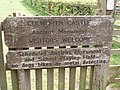 Culworth Castle sign - geograph.org.uk - 431253.jpg 640 × 480 ; 149 kio
-
 Culworth clock - geograph.org.uk - 4473621.jpg 480 × 640 ; 88 kio
-
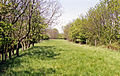
 Culworth Farmland - geograph.org.uk - 1339331.jpg 640 × 480 ; 83 kio
-
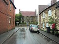
 Culworth High Street - geograph.org.uk - 3039855.jpg 640 × 480 ; 71 kio
-
 Culworth Village Green - geograph.org.uk - 3039820.jpg 640 × 480 ; 68 kio
-
 Culworth-High Street - geograph.org.uk - 3032235.jpg 640 × 480 ; 87 kio
-
 Culworth-The Old Forge - geograph.org.uk - 3039831.jpg 640 × 480 ; 60 kio
-
 Curious Stone - geograph.org.uk - 4473626.jpg 480 × 640 ; 104 kio
-
 Eydon Road Halt site geograph-3465457-by-Ben-Brooksbank.jpg 2 395 × 1 515 ; 4 Mio
-
 Farmhouse - geograph.org.uk - 4473627.jpg 640 × 480 ; 80 kio
-
 Farmland - geograph.org.uk - 4473638.jpg 480 × 640 ; 54 kio
-
 Farmland with sheep - geograph.org.uk - 4473619.jpg 640 × 480 ; 96 kio
-
 Farmland, Culworth - geograph.org.uk - 6166405.jpg 1 024 × 768 ; 212 kio
-
 Farmland, Culworth - geograph.org.uk - 6166408.jpg 1 024 × 768 ; 223 kio
-
 Farmland, Culworth - geograph.org.uk - 6166411.jpg 1 024 × 768 ; 230 kio
-
 Field path - geograph.org.uk - 4473618.jpg 480 × 640 ; 92 kio
-
 Garden Wall^ - geograph.org.uk - 4473628.jpg 640 × 480 ; 80 kio
-
 Gate in garden wall - geograph.org.uk - 4473632.jpg 480 × 640 ; 85 kio
-
 Lane and Fulford House (geograph 6585084).jpg 1 024 × 768 ; 264 kio
-
 Map for Battle of Edgecote by Ramsay.jpg 2 060 × 1 524 ; 911 kio
-
 NW near Culworth, towards Eydon - geograph.org.uk - 4148806.jpg 2 348 × 1 455 ; 3,68 Mio
-
 Old cultivator - geograph.org.uk - 815314.jpg 640 × 480 ; 138 kio
-
 Pasture, Culworth - geograph.org.uk - 6166409.jpg 1 024 × 768 ; 275 kio
-
 Phone Box - geograph.org.uk - 4473624.jpg 480 × 640 ; 85 kio
-
 Queens Street - geograph.org.uk - 2927151.jpg 3 547 × 2 662 ; 1,3 Mio
-
 Railway Bridge - geograph.org.uk - 4473636.jpg 480 × 640 ; 128 kio
-
 Road passes east of Culworth - geograph.org.uk - 1768649.jpg 640 × 480 ; 60 kio
-
 St. Peter's House, Culworth (geograph 6344623).jpg 1 024 × 768 ; 139 kio
-
 Swallow Hole - geograph.org.uk - 4473634.jpg 640 × 480 ; 136 kio
-
 The Old Manor House, Culworth (geograph 6344624).jpg 1 024 × 768 ; 259 kio
-
 The Red Lion - geograph.org.uk - 190751.jpg 640 × 480 ; 100 kio
-
 Turning for Culworth - geograph.org.uk - 1768640.jpg 640 × 480 ; 55 kio
-
 Culworth - geograph.org.uk - 406756.jpg 640 × 480 ; 116 kio
-
 Culworth - geograph.org.uk - 412571.jpg 640 × 480 ; 204 kio
-
 Culworth Castle - geograph.org.uk - 431247.jpg 640 × 480 ; 109 kio
-

-
 Farm track from Banbury Road - geograph.org.uk - 202593.jpg 640 × 480 ; 49 kio
-
 Sunset from Banbury Lane - geograph.org.uk - 540265.jpg 2 816 × 2 112 ; 931 kio


.jpg)


.jpg)

.jpg)


