Category:Cwm, Denbighshire
Zur Navigation springen
Zur Suche springen
Ort in Wales   | |||||
| Medium hochladen | |||||
| Aussprache (Audiodatei) | |||||
|---|---|---|---|---|---|
| Ist ein(e) | |||||
| Ort | Denbighshire, Wales | ||||
| Einwohnerzahl |
| ||||
| Fläche |
| ||||
 | |||||
Unterkategorien
Es werden 2 von insgesamt 2 Unterkategorien in dieser Kategorie angezeigt:
In Klammern die Anzahl der enthaltenen Kategorien (K), Seiten (S), Dateien (D)
C
M
- Mynydd y Cwm (7 D)
Medien in der Kategorie „Cwm, Denbighshire“
Folgende 112 Dateien sind in dieser Kategorie, von 112 insgesamt.
-
 A glimpse of the sea - geograph.org.uk - 6155427.jpg 1.024 × 683; 178 KB
-
 A55 Rhuallt Hill - geograph.org.uk - 3653465.jpg 5.184 × 3.456; 3,92 MB
-
 A55, Rhuallt Hill - geograph.org.uk - 3157206.jpg 640 × 430; 44 KB
-
 Access Track from Pen-y-Mynydd - geograph.org.uk - 1335904.jpg 640 × 480; 135 KB
-
 Access Track from Tyddyn-y-cyll - geograph.org.uk - 1335982.jpg 640 × 480; 83 KB
-
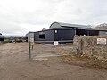
 Barns at Cilgwyn farm - geograph.org.uk - 6059220.jpg 4.000 × 3.000; 2,94 MB
-

-
 Board walk on the Clwydian Way - geograph.org.uk - 3397222.jpg 1.024 × 768; 384 KB
-
-
 Brynllithrig Hall - geograph.org.uk - 6155399.jpg 1.024 × 683; 238 KB
-
 Brynllithrig Hall - geograph.org.uk - 6202058.jpg 1.024 × 758; 385 KB
-
 Cae indrawn - A maize field - geograph.org.uk - 2680749.jpg 480 × 640; 108 KB
-
-
 Cattle feeding on silage - geograph.org.uk - 6059561.jpg 4.000 × 3.000; 2,76 MB
-
 Cilgwyn Farm - geograph.org.uk - 6059212.jpg 4.000 × 3.000; 2,37 MB
-
 Cilgwyn Farm buildings - geograph.org.uk - 6059211.jpg 4.000 × 3.000; 2,07 MB
-

-
 Cwm (geograph 2305580).jpg 1.280 × 857; 241 KB
-
 Cwm Road approaching Pentre Cwm - geograph.org.uk - 5987241.jpg 4.000 × 3.000; 3,67 MB
-
 Cynhaeafu - Harvesting - geograph.org.uk - 5568679.jpg 640 × 430; 83 KB
-
-
 Descending off Marian Ffrith - geograph.org.uk - 1335977.jpg 640 × 480; 71 KB
-
 Descending Rhuallt Hill - geograph.org.uk - 3157216.jpg 640 × 371; 48 KB
-
 Farm building, Hottia - geograph.org.uk - 6052933.jpg 4.000 × 3.000; 2,29 MB
-
 Field below Coed Cwm - geograph.org.uk - 1335942.jpg 640 × 480; 72 KB
-
 Field off Hiraddug Road - geograph.org.uk - 6059204.jpg 4.000 × 3.000; 3,03 MB
-
 Field surrounded by woodland - geograph.org.uk - 6052999.jpg 4.000 × 3.000; 2,93 MB
-
 Forest track in Coed Cwm - geograph.org.uk - 6053667.jpg 4.000 × 3.000; 2,81 MB
-
 Forest track in Coed Cwm - geograph.org.uk - 6053671.jpg 4.000 × 3.000; 2,9 MB
-

-

-
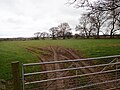
 Gates leading to fields - geograph.org.uk - 6155414.jpg 1.024 × 683; 219 KB
-
 Giat cae - A field gate - geograph.org.uk - 2680756.jpg 640 × 480; 90 KB
-
 Graveyard at Cwm - geograph.org.uk - 6053003.jpg 4.000 × 3.000; 2,54 MB
-
 Graveyard, St Mael ^ St Sulien - geograph.org.uk - 6053001.jpg 4.000 × 3.000; 2,87 MB
-
 Grazing field and Pen-y-rhos wood - geograph.org.uk - 3397137.jpg 1.024 × 768; 214 KB
-
 Grazing Field by Bryn Glas Farm - geograph.org.uk - 3397097.jpg 1.024 × 768; 292 KB
-
 Gwrych wedi ei blethu - A laid hedge - geograph.org.uk - 5568659.jpg 640 × 606; 184 KB
-
 Harvested conifers, Coed Cwm - geograph.org.uk - 6155419.jpg 1.024 × 683; 257 KB
-

-
 Heading down Hiraddug Road towards Dyserth - geograph.org.uk - 6059530.jpg 4.000 × 3.000; 2,3 MB
-

-

-
 Hendre-Fawr Farm - geograph.org.uk - 3397166.jpg 1.024 × 768; 155 KB
-
 Hiraddug Road - geograph.org.uk - 6058791.jpg 4.000 × 3.000; 2,67 MB
-
 Hooded tomb in the churchyard of Saints Mael and Sulien - geograph.org.uk - 6052998.jpg 4.000 × 3.000; 2,9 MB
-
 Hottia farm, south of Dyserth - geograph.org.uk - 6052928.jpg 4.000 × 3.000; 2,41 MB
-
 Junction of minor lanes at Pan-y-rhos - geograph.org.uk - 3396816.jpg 1.024 × 768; 267 KB
-

-
 Llwybr Clawdd Offa - Offa's Dyke Path - geograph.org.uk - 3953715.jpg 2.448 × 3.264; 3,61 MB
-
 Llwybr Clawdd Offa - Offa's Dyke Path - geograph.org.uk - 3954002.jpg 3.264 × 2.448; 3,97 MB
-
 Llwybr Clawdd Offa - Offa's Dyke Path - geograph.org.uk - 3955209.jpg 3.264 × 2.448; 3,66 MB
-

-
 Marian Bach - geograph.org.uk - 5568671.jpg 640 × 480; 81 KB
-
 Marian Cwm - geograph.org.uk - 4526052.jpg 640 × 405; 75 KB
-
 Marian Ffrith - geograph.org.uk - 1335972.jpg 640 × 480; 96 KB
-
 Marian Ffrith - geograph.org.uk - 3953843.jpg 3.264 × 2.448; 3,58 MB
-
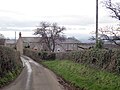
 Minor road near Fron - geograph.org.uk - 5987238.jpg 4.000 × 3.000; 3,27 MB
-
 Mud, mud, glorious mud - geograph.org.uk - 6059558.jpg 4.000 × 3.000; 2,7 MB
-
 North Wales Expressway - geograph.org.uk - 6053674.jpg 4.000 × 3.000; 3,01 MB
-

-

-
 Offa's Dyke Path at Morwylfa - geograph.org.uk - 6202067.jpg 1.024 × 768; 289 KB
-
 Offa's Dyke Path by Brynllithrig Hall - geograph.org.uk - 1335871.jpg 640 × 480; 142 KB
-

-
 Offa's Dyke path near Bodlonfa - geograph.org.uk - 6155407.jpg 1.024 × 683; 189 KB
-
 Offa's Dyke Path near Tyddyn-y-cyll - geograph.org.uk - 1336004.jpg 640 × 480; 105 KB
-
 Offa's Dyke Path on Mynydd y Cwm - geograph.org.uk - 1335886.jpg 640 × 480; 100 KB
-
 Offa's Dyke Path signpost - geograph.org.uk - 6059556.jpg 4.000 × 3.000; 2,88 MB
-
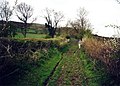
 Offa's Dyke Path south of Marian Cwm - geograph.org.uk - 1335953.jpg 640 × 480; 111 KB
-

-
 On the Clwydian Way - geograph.org.uk - 3397190.jpg 1.024 × 768; 358 KB
-
 Parish Church of Saints Mael and Sulien - geograph.org.uk - 6052944.jpg 3.771 × 2.829; 2,02 MB
-
 Parish Church of Saints Mael and Sulien - geograph.org.uk - 6052996.jpg 4.000 × 3.000; 2,53 MB
-
 Parish Church of Saints Mael and Sulien - geograph.org.uk - 6052997.jpg 3.736 × 2.803; 1,96 MB
-

-
 Pen-y-Rhos - geograph.org.uk - 6058794.jpg 3.757 × 2.769; 2,63 MB
-

-
 Rhuallt Hill on the A55 - geograph.org.uk - 6144150.jpg 640 × 427; 72 KB
-
 Rollercoaster road near Cwm - geograph.org.uk - 6053012.jpg 4.000 × 3.000; 2,88 MB
-
 Seat with a view - geograph.org.uk - 6053662.jpg 4.000 × 3.000; 2,82 MB
-
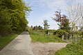
 Shallow lake beside the Clwydian Way - geograph.org.uk - 3397408.jpg 1.024 × 768; 254 KB
-
 Square and compasses - geograph.org.uk - 3397383.jpg 800 × 600; 199 KB
-
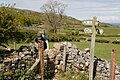 Stile and finger post, Offa's Dyke path - geograph.org.uk - 6155435.jpg 1.024 × 683; 248 KB
-
 Stile and gate below Y Foel - geograph.org.uk - 6155440.jpg 1.024 × 683; 186 KB
-
 Stile on Offas Dyke Path - geograph.org.uk - 1736798.jpg 3.648 × 2.736; 1,43 MB
-
 Stile on the Clwydian Way - geograph.org.uk - 3397206.jpg 1.024 × 768; 315 KB
-
 Stiles on the Offa's Dyke path - geograph.org.uk - 6155431.jpg 1.024 × 683; 229 KB
-
 Tan Y Bryn - geograph.org.uk - 6053015.jpg 4.000 × 3.000; 2,4 MB
-
 Tan-y-Bryn - geograph.org.uk - 2681222.jpg 508 × 640; 57 KB
-
 Terfyn, Dyserth - geograph.org.uk - 5568683.jpg 640 × 480; 63 KB
-
 The Blue Lion Inn, Cwm - geograph.org.uk - 6052942.jpg 4.000 × 3.000; 2,43 MB
-
 The railway bridge that never was - geograph.org.uk - 6155486.jpg 1.024 × 683; 241 KB
-
 The Vicarage, Cwm - geograph.org.uk - 6053009.jpg 4.000 × 3.000; 2,47 MB
-
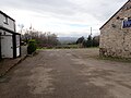 The yard of the Blue Lion, Cwm - geograph.org.uk - 6053010.jpg 4.000 × 3.000; 2,25 MB
-
 Track towards Marian Mill - geograph.org.uk - 1336014.jpg 640 × 480; 111 KB
-
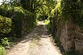
 Track, Coed Cwm - geograph.org.uk - 1286458.jpg 640 × 480; 138 KB
-
 Tree and a rusted fence by Offa's Dyke path - geograph.org.uk - 6155447.jpg 683 × 1.024; 273 KB
-
-

-
 Tyddyn-y-cyll - geograph.org.uk - 6202062.jpg 1.024 × 768; 256 KB
-
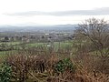
 Vale of Clwyd - geograph.org.uk - 2305620.jpg 1.280 × 856; 201 KB
-
 View from Dyserth - Rhuallt road - geograph.org.uk - 6053661.jpg 4.000 × 3.000; 2,35 MB
-

-
 View over the Vale of Clwyd - geograph.org.uk - 3587870.jpg 640 × 427; 397 KB
-
 View to Dyserth and the coast - geograph.org.uk - 6059532.jpg 4.000 × 3.000; 2,49 MB
-

-
 Wales Denbighshire Community Cwm map.svg 512 × 773; 560 KB
-
 Water wheel, Marian Mills - geograph.org.uk - 6155481.jpg 683 × 1.024; 255 KB
-
 Wild flowers next to the lane - geograph.org.uk - 6155409.jpg 1.024 × 683; 191 KB
-

-
 Entrance to Cwm - geograph.org.uk - 26220.jpg 384 × 288; 35 KB


.jpg)


