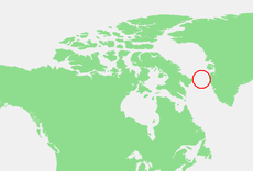
Category:Davis Strait
Zur Navigation springen
Zur Suche springen
Meerenge zwischen Kanada und Grönland | |||||
| Medium hochladen | |||||
| Ist ein(e) | |||||
|---|---|---|---|---|---|
| Ist Teil von | |||||
| Benannt nach | |||||
| Ort | Nunavut, Kanada | ||||
| Liegt am oder im Gewässer | |||||
| Physisch verbunden mit | |||||
| Besteht aus | |||||
| Schlüsselereignis |
| ||||
| Breite |
| ||||
| Länge |
| ||||
 | |||||
Unterkategorien
Es werden 6 von insgesamt 6 Unterkategorien in dieser Kategorie angezeigt:
In Klammern die Anzahl der enthaltenen Kategorien (K), Seiten (S), Dateien (D)
Medien in der Kategorie „Davis Strait“
Folgende 51 Dateien sind in dieser Kategorie, von 51 insgesamt.
-
1598 map of the Polar Regions by Willem Barentsz.jpg 13.719 × 10.160; 30,66 MB
-
Emanuel A. Petersen - Parti med isbjerg fra Davisstrædet - 1923.png 2.000 × 1.440; 6,82 MB
-
330-PSA-167-60 (USN 710774) (20674941294).jpg 2.832 × 2.132; 1,36 MB
-
330-PSA-167-60 (USN 710778) (21109737408).jpg 2.893 × 2.248; 1,25 MB
-
330-PSA-167-60 (USN 710779) (21287000322).jpg 2.284 × 2.888; 1,63 MB
-
A Davis Strait iceberg.jpg 971 × 536; 239 KB
-
Auyuittuq NP northern end 1 1997-08-07.jpg 5.256 × 3.444; 445 KB
-
Baffinisland pho 2013102 lrg.jpg 2.385 × 1.590; 829 KB
-
Barents third voyage.jpg 2.000 × 1.511; 965 KB
-
Barentskartet, 1598 (12068020364).jpg 2.842 × 2.091; 3,85 MB
-
Barentsz Full Map.jpg 1.000 × 742; 258 KB
-
Cloud streets in Davis Strait (8539094973).jpg 5.000 × 6.400; 5,43 MB
-
Cruise ship moored in Kimmirut Harbour.jpg 2.400 × 1.751; 1,88 MB
-
Davis Strait (MODIS 2020-07-19).jpg 4.419 × 3.865; 1,62 MB
-
Davis Strait Icebergs.jpg 1.024 × 768; 204 KB
-
Davis Strait, West of Greenland.jpg 3.264 × 2.448; 2,8 MB
-
Forminsket utgave av Barentskartet - no-nb krt 00487.jpg 4.418 × 3.449; 3,45 MB
-
I. E. C. Rasmussen - Humpback whale and sailing ship in the Davis Strait (1870).jpg 3.238 × 2.214; 2,39 MB
-
Ice Flow (52625138186).jpg 1.024 × 768; 196 KB
-
Iceberg (52629197766).jpg 1.024 × 768; 200 KB
-
Icebergs in Davis Strait Icebergs dans le détroit de Davis (48188945877).jpg 1.000 × 758; 158 KB
-
IceBridge Flight Over Baffin Island.jpg 2.400 × 1.590; 4,12 MB
-
James H. Wheldon - Hull Whaler 'Harmony' KINCM 2007.1441.jpg 800 × 606; 73 KB
-
John Ward - 'William Lee' in the Arctic 2007.2281.jpg 1.000 × 656; 563 KB
-
John Ward - The 'William Lee' in the Arctic 2007.1439.jpg 800 × 564; 319 KB
-
Kangerlussuaq-fjord-mouth.jpg 3.700 × 1.700; 1,18 MB
-
Kangerlussuatsiaaq.jpg 3.800 × 2.056; 1,91 MB
-
Kangerlussuatsiaq-fjord-mouth.jpg 3.800 × 1.000; 944 KB
-
Midnight Sun (52626168665).jpg 1.024 × 768; 196 KB
-
Pontanus 1611 Arctic Map.jpg 2.852 × 2.142; 802 KB
-
Robbenjagd 2000.jpg 1.181 × 847; 82 KB
-
Robert Dodd - The North West or Davis's Streights Whale Fishery (cropped).jpg 1.024 × 602; 115 KB
-
Royal Danish Naval Vessel Knut Rasmussen participates in Operation Nanook 2010.jpg 2.784 × 1.848; 1,99 MB
-
Sea Ice off Baffin Island.jpg 4.400 × 6.000; 3,4 MB
-
Seven Islands (52633611379).jpg 1.024 × 768; 205 KB
-
Ship 'Harmony' of Hull.jpg 1.920 × 1.248; 505 KB
-
Simiutaq.jpg 3.872 × 1.000; 967 KB
-
Sisimiut-nasaasaaq-from-palasip-qaqqaa.jpg 3.872 × 2.176; 3,44 MB
-
Smoke cloud over the Davis Strait (Copernicus).jpg 3.827 × 2.567; 2,92 MB
-
The mountains of Atlantis sinking into a far sea.jpg 2.400 × 2.008; 2,56 MB
-
John Ward - The 'Swan' and 'Isabella' ERY HUMM 2007 1442.jpg 800 × 524; 69 KB
-
Ward-of-hull fishery.jpg 4.096 × 2.775; 2,36 MB


