Category:Denbigh
Aller à la navigation
Aller à la recherche
localité britannique   | |||||
| Téléverser des médias | |||||
| Nature de l’élément | |||||
|---|---|---|---|---|---|
| Partie de | |||||
| Lieu | Denbighshire, pays de Galles | ||||
| site officiel | |||||
 | |||||
Български: 300px|мини|Руините на замъка "Денби Касъл"
Cymraeg: Mae Dinbych ( Saesneg: Denbigh) (Cyfeirnod OS: SJ0566) yn dref hanesyddol yn Sir Ddinbych. Ceir Dinbych y Pysgod yn ne Cymru hefyd a thref o'r un enw yn Virginia.
Deutsch: Denbigh ( walisisch: Dinbych) ist eine Kleinstadt in Wales. Sie war bis 1888 die Hauptstadt der traditionellen Grafschaft Denbighshire.
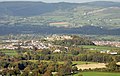
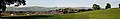
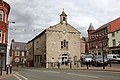
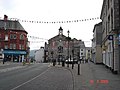
English: Denbigh is a market town in Denbighshire, Wales. Before 1888, it was county town of Denbighshire. Denbigh lies 8 miles to the north west of Ruthin and to the south of St Asaph. It is about 13 miles (20 km) from the Irish Sea port of Rhyl. The town grew around the glove-making industry. Its population at the 2001 Census was 8,783.
Euskara: Denbigh/Dinbych Galesko iparraldean dagoen kostaldeko udalerria da, Denbighshire-ko konderrian dagoena.
Français : Dinbych, en anglais Denbigh, est une ville située au nord du Pays de Galles, sur les rives de la rivière Clwyd. Elle a donné son nom au Sir Ddinbych, en anglais Denbighshire. Dinbych a été réputé pour son industrie du gant, et son hôpital psychiatrique, le plus grand employeur local avant sa fermeture dans les années 1990.
Nederlands: Denbigh is een plaats in Wales, in het bestuurlijke graafschap Denbighshire en in het ceremoniële behouden graafschap Clwyd. De plaats telt 8783 inwoners.
Norsk bokmål: Denbigh ( walisisk Dinbych) er en by i Denbighshire i Wales. Den var administrasjonsby i det tradisjonelle grevskapet Denbighshire. Byen ligger ved elven Clwyd, og vokste opp omkring hanskemakerindustrien.
Sous-catégories
Cette catégorie comprend 23 sous-catégories, dont les 23 ci-dessous.
2
A
B
- Baptist Chapel, Denbigh (1 F)
- Brookhouse, Denbighshire (5 F)
- Burgess Gate (9 F)
D
- Denbigh Cockpit (26 F)
- Denbigh Conservative Club (8 F)
- Denbigh Friary (3 F)
- Denbigh railway station (5 F)
- Denbigh surrounding area (33 F)
- Denbigh Town Hall (2 F)
G
- Golden Lion, Denbigh (7 F)
L
- Leicester's Church, Denbigh (5 F)
M
- Old maps of Denbigh (3 F)
N
S
- St Hilary's Chapel, Denbigh (19 F)
T
- The Hand Inn, Denbighshire (3 F)
W
- Denbigh Town Walls (7 F)
Média dans la catégorie « Denbigh »
Cette catégorie comprend 442 fichiers, dont les 200 ci-dessous.
(page précédente) (page suivante)-
 "Denbigh Mental" - geograph.org.uk - 2163049.jpg 640 × 480 ; 77 kio
-
 1 Vale Street, Denbigh - geograph.org.uk - 6057008.jpg 3 871 × 2 903 ; 1,93 Mio
-
 A section of hedge-lined road from Pont Ystrad to Llanrhaeadr - geograph.org.uk - 5982788.jpg 4 000 × 3 000 ; 3,02 Mio
-
 A tributary of the river Ystrad - geograph.org.uk - 4855099.jpg 640 × 514 ; 115 kio
-
 A525 near Bryn-hyfryd - geograph.org.uk - 4034546.jpg 640 × 481 ; 47 kio
-
 A525 north of Denbigh Green - geograph.org.uk - 4034550.jpg 640 × 481 ; 42 kio
-
 A525 northbound at Ty Newydd - geograph.org.uk - 4034556.jpg 640 × 481 ; 43 kio
-
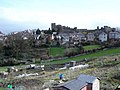 Allotments and castle - geograph.org.uk - 142423.jpg 640 × 480 ; 86 kio
-
 Allotments at Denbigh - geograph.org.uk - 5714343.jpg 640 × 480 ; 95 kio
-
 Artifact in the ruins of Dr. Johnson's Cottage - geograph.org.uk - 2815435.jpg 640 × 480 ; 127 kio
-
 Artifacts discovered eroding out of the bluff (c0d8d7db-1dd8-b71c-07a6-f7d35af4f1f4).jpg 1 200 × 900 ; 582 kio
-
 B5382 at Denbigh boundary sign - geograph.org.uk - 4034523.jpg 640 × 481 ; 49 kio
-
 Back Row, Denbigh - geograph.org.uk - 4696946.jpg 3 184 × 2 123 ; 1,73 Mio
-
 Bench in woodland near Kings Mill, Denbigh - geograph.org.uk - 2316541.jpg 640 × 480 ; 161 kio
-
 Bench mark near the entrance to Denbigh Castle - geograph.org.uk - 4944544.jpg 2 581 × 1 935 ; 1,74 Mio
-
 Bench mark on a wall junction in Castle Lane - geograph.org.uk - 4943391.jpg 4 580 × 3 432 ; 4,3 Mio
-
 Bench mark on the lodge at the corner of Castle Lane - geograph.org.uk - 4943123.jpg 3 888 × 5 184 ; 6,64 Mio
-
 Bench mark on the wall in Castle Lane - geograph.org.uk - 4943348.jpg 4 585 × 3 432 ; 4,15 Mio
-

-
 Blychau Ffon - Phone boxes - geograph.org.uk - 6300274.jpg 640 × 586 ; 106 kio
-
 Britannia Inn, Denbigh - geograph.org.uk - 2155902.jpg 640 × 474 ; 80 kio
-
 Bronyffynnon Surgery, Denbigh - geograph.org.uk - 667544.jpg 480 × 640 ; 48 kio
-
 Brookhouse Mill, Denbigh - geograph.org.uk - 6352109.jpg 528 × 396 ; 34 kio
-
 Bryn y Parc, Denbigh.jpg 826 × 768 ; 210 kio
-
 Bull Lane, Denbigh - geograph.org.uk - 2156496.jpg 480 × 640 ; 62 kio
-
 Byrnau ger Coed Derw - Bales near Coed Derw - geograph.org.uk - 3672699.jpg 640 × 480 ; 67 kio
-
 Calch Hill near Denbigh - geograph.org.uk - 2815499.jpg 640 × 480 ; 68 kio
-
 Capel Mawr, Denbigh (geograph 5393389).jpg 640 × 480 ; 59 kio
-
 Capel y Green - geograph.org.uk - 4111865.jpg 1 024 × 824 ; 151 kio
-
 Capel y Green - geograph.org.uk - 5725649.jpg 640 × 472 ; 58 kio
-
 Castle Hill, Denbigh - geograph.org.uk - 2156327.jpg 640 × 480 ; 69 kio
-
 Castle Hill, Denbigh - geograph.org.uk - 2307945.jpg 1 280 × 856 ; 175 kio
-
 Castle Hill, Denbigh - geograph.org.uk - 4676153.jpg 6 000 × 4 000 ; 3,77 Mio
-
 Castle Lane and a bench mark - geograph.org.uk - 4943301.jpg 5 184 × 3 888 ; 5,1 Mio
-
 Castle Lane and a bench mark - geograph.org.uk - 4943378.jpg 5 184 × 3 888 ; 5,49 Mio
-
 Castle Lane wall, the castle and a bench mark - geograph.org.uk - 4943404.jpg 5 184 × 3 888 ; 4,1 Mio
-
 Castle Lane, Denbigh - geograph.org.uk - 2155948.jpg 640 × 480 ; 72 kio
-
 Castle Lodge, Love Lane - geograph.org.uk - 2155942.jpg 640 × 480 ; 83 kio
-
 Chen Lin Chinese Restaurant, Back Lane - geograph.org.uk - 6066891.jpg 4 000 × 3 000 ; 2,68 Mio
-
 Christmas comes early to Denbigh - geograph.org.uk - 2163069.jpg 487 × 640 ; 79 kio
-

-

-
 Clwydian House, Denbigh - geograph.org.uk - 2157494.jpg 640 × 480 ; 67 kio
-
 Clwydian Mountain Range - geograph.org.uk - 3105027.jpg 3 889 × 1 817 ; 1,64 Mio
-
 Coat of arms, Howell's School, Denbigh (8200462808).jpg 4 272 × 2 848 ; 3,73 Mio
-
 Colomendy Industrial Estate from the air - geograph.org.uk - 1189942.jpg 640 × 427 ; 95 kio
-
 Coppy Farm - geograph.org.uk - 3672729.jpg 640 × 480 ; 56 kio
-
 Crenellated houses on Castle Hill, Denbigh - geograph.org.uk - 2156335.jpg 640 × 480 ; 71 kio
-
 Crown Square, Denbigh (geograph 4676418).jpg 6 000 × 4 000 ; 3,64 Mio
-
 Crown Square, Denbigh - geograph.org.uk - 2298578.jpg 1 280 × 856 ; 205 kio
-
 Crown Square, Denbigh - geograph.org.uk - 4696935.jpg 3 184 × 2 123 ; 2,03 Mio
-
 Dafyddapgwilym1939.jpg 5 201 × 3 049 ; 1,49 Mio
-
 DBP Home Improvements - geograph.org.uk - 6224509.jpg 1 600 × 1 065 ; 348 kio
-
 Decorative manhole cover, Broomhill Lane - geograph.org.uk - 5700132.jpg 640 × 480 ; 109 kio
-
 Decorative manhole cover, Broomhill Lane - geograph.org.uk - 5700134.jpg 640 × 480 ; 107 kio
-
 Decorative manhole cover, Broomhill Lane - geograph.org.uk - 5700135.jpg 640 × 480 ; 114 kio
-
 Denbigh - geograph.org.uk - 4675495.jpg 4 662 × 2 995 ; 1,63 Mio
-
 Denbigh - geograph.org.uk - 54788.jpg 512 × 384 ; 36 kio
-
 Denbigh - geograph.org.uk - 6323231.jpg 3 648 × 2 736 ; 3,18 Mio
-
 Denbigh Alleyway - geograph.org.uk - 4699977.jpg 3 184 × 2 123 ; 2,46 Mio
-
 Denbigh and its castle - geograph.org.uk - 1601695.jpg 640 × 408 ; 95 kio
-
 Denbigh and its Castle - geograph.org.uk - 595409.jpg 640 × 480 ; 51 kio
-
 Denbigh Bowling Green - geograph.org.uk - 6085206.jpg 4 000 × 3 000 ; 2,4 Mio
-
 Denbigh by-pass - geograph.org.uk - 2741883.jpg 640 × 480 ; 96 kio
-
 Denbigh Castle - geograph.org.uk - 2765878.jpg 1 600 × 1 067 ; 380 kio
-
 Denbigh Castle - geograph.org.uk - 3084265.jpg 754 × 1 024 ; 281 kio
-
 Denbigh Castle - geograph.org.uk - 3634951.jpg 1 024 × 680 ; 211 kio
-
 Denbigh Castle - geograph.org.uk - 3634967.jpg 680 × 1 024 ; 203 kio
-
 Denbigh Castle - geograph.org.uk - 4676140.jpg 6 000 × 4 000 ; 4,06 Mio
-
 Denbigh Castle - the Great Gatehouse (2) detail - geograph.org.uk - 3065785.jpg 427 × 640 ; 442 kio
-
 Denbigh Castle - the Great Gatehouse - geograph.org.uk - 3065776.jpg 640 × 444 ; 322 kio
-
 Denbigh Castle and Moel Famau - geograph.org.uk - 2783000.jpg 3 872 × 2 592 ; 3,83 Mio
-
 Denbigh Castle and the Clwydian Hills - geograph.org.uk - 2791893.jpg 7 222 × 1 163 ; 5,19 Mio
-
 Denbigh Castle and the Clwydian Hills - geograph.org.uk - 2815489.jpg 640 × 480 ; 65 kio
-
 Denbigh Castle entrance path - geograph.org.uk - 6134685.jpg 7 276 × 4 850 ; 7,03 Mio
-
 Denbigh Castle from Castle Lane - geograph.org.uk - 6134682.jpg 6 839 × 4 559 ; 7,53 Mio
-
 Denbigh Castle from Galch Hill - geograph.org.uk - 3065755.jpg 640 × 427 ; 318 kio
-
 Denbigh Castle gatehouse ruins - geograph.org.uk - 2814635.jpg 640 × 480 ; 72 kio
-
 Denbigh Castle ruins - geograph.org.uk - 6348127.jpg 5 184 × 3 888 ; 4,15 Mio
-
 Denbigh Castle walls - geograph.org.uk - 6244544.jpg 5 184 × 3 888 ; 3,33 Mio
-
 Denbigh Castle Walls and Well - geograph.org.uk - 4701369.jpg 4 774 × 3 178 ; 3,24 Mio
-
 Denbigh Castle, East Wall and Cool Basement - geograph.org.uk - 4701462.jpg 3 184 × 2 123 ; 2,23 Mio
-
 Denbigh Castle, North Wales - 53148134147.jpg 5 902 × 2 920 ; 3,05 Mio
-
 Denbigh Castle, North Wales - 53148134267.jpg 5 944 × 2 556 ; 3,5 Mio
-
 Denbigh Castle, North Wales - 53148134762.jpg 6 000 × 4 000 ; 9,91 Mio
-
 Denbigh Castle, North Wales - 53148134842.jpg 6 000 × 4 000 ; 9,41 Mio
-
 Denbigh Castle, North Wales - 53148709431.jpg 4 957 × 3 473 ; 2,99 Mio
-
 Denbigh Castle, North Wales - 53148709461.jpg 6 000 × 4 000 ; 8,13 Mio
-
 Denbigh Castle, North Wales - 53148709496.jpg 4 691 × 1 919 ; 1,49 Mio
-
 Denbigh Castle, North Wales - 53148915964.jpg 5 363 × 2 430 ; 3,23 Mio
-
 Denbigh Castle, North Wales - 53148916009.jpg 4 733 × 3 151 ; 3,99 Mio
-
 Denbigh Castle, North Wales - 53148916184.jpg 5 356 × 3 963 ; 4,11 Mio
-
 Denbigh Castle, North Wales - 53149144170.jpg 3 671 × 3 781 ; 3,45 Mio
-
 Denbigh Castle, North Wales - 53149206223.jpg 3 443 × 5 303 ; 2,56 Mio
-
 Denbigh Castle, North Wales - 53149207378.jpg 6 000 × 4 000 ; 9,07 Mio
-
 Denbigh Castle, North Wales.jpg 6 000 × 4 000 ; 9,02 Mio
-
 Denbigh Chocolate Shop - geograph.org.uk - 2156502.jpg 469 × 640 ; 75 kio
-
 Denbigh Citizens Advice Bureau - geograph.org.uk - 667351.jpg 480 × 640 ; 62 kio
-
 Denbigh Coat of Arms - geograph.org.uk - 666855.jpg 539 × 640 ; 71 kio
-
 Denbigh Community Orchard - geograph.org.uk - 4855780.jpg 640 × 480 ; 99 kio
-
 Denbigh Conservative Club - geograph.org.uk - 5700128.jpg 640 × 480 ; 66 kio
-
 Denbigh Friary - geograph.org.uk - 2301775.jpg 1 280 × 856 ; 294 kio
-
 Denbigh from Castle Lane (looking in a north westerly direction) - geograph.org.uk - 6134684.jpg 6 388 × 4 258 ; 6,74 Mio
-
 Denbigh Golf Course - geograph.org.uk - 5325463.jpg 640 × 480 ; 92 kio
-
 Denbigh houses - geograph.org.uk - 32720.jpg 358 × 269 ; 15 kio
-
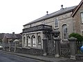
 Denbigh Library (geograph 4696820).jpg 5 184 × 3 456 ; 4,64 Mio
-
 Denbigh Library - geograph.org.uk - 6244540.jpg 5 184 × 3 888 ; 2,57 Mio
-
 Denbigh Library - geograph.org.uk - 666848.jpg 640 × 480 ; 69 kio
-
 Denbigh Nature (enhanced).jpg 960 × 540 ; 158 kio
-
 Denbigh Nature (original).jpg 1 600 × 900 ; 762 kio
-
 Denbigh Post Office - geograph.org.uk - 2307793.jpg 1 280 × 856 ; 175 kio
-
 Denbigh Retail Park - geograph.org.uk - 5677418.jpg 640 × 480 ; 69 kio
-
 Denbigh Rugby Club - geograph.org.uk - 32721.jpg 410 × 307 ; 24 kio
-
 Denbigh seen from fields near Gwaynynog - geograph.org.uk - 2815483.jpg 640 × 480 ; 86 kio
-
 Denbigh Tennis Club - geograph.org.uk - 4904242.jpg 640 × 479 ; 71 kio
-
 Denbigh town centre - geograph.org.uk - 54787.jpg 512 × 384 ; 34 kio
-
 Denbigh Town Walls - geograph.org.uk - 4702291.jpg 3 184 × 2 123 ; 3,26 Mio
-
 Denbigh Town Walls - geograph.org.uk - 4702300.jpg 4 184 × 2 789 ; 4,28 Mio
-
 Denbigh Town Walls - geograph.org.uk - 4702310.jpg 4 184 × 2 789 ; 3,73 Mio
-
 Denbigh Town Walls - geograph.org.uk - 4702596.jpg 4 184 × 2 789 ; 4,5 Mio
-
 Denbigh Town Walls - geograph.org.uk - 4702600.jpg 4 184 × 2 789 ; 4,73 Mio
-
 Denbigh Vale Street geograph-3388568-by-Ben-Brooksbank.jpg 2 390 × 1 352 ; 3,49 Mio
-
 Denbigh War Memorial.jpg 1 682 × 2 244 ; 694 kio
-
 Denbigh, the town and castle (10723873485).jpg 1 000 × 699 ; 619 kio
-
 Diamond Buildings, Denbigh 01.jpg 1 090 × 1 577 ; 304 kio
-
 Dilapidated barn at Calch Hill near Denbigh - geograph.org.uk - 2815495.jpg 640 × 480 ; 115 kio
-
 Door to the Golden Lion - geograph.org.uk - 6066889.jpg 4 000 × 3 000 ; 2,48 Mio
-
 Dr Livingstone I Presume - geograph.org.uk - 5299368.jpg 630 × 640 ; 116 kio
-
 Dr. Johnson's Cottage near Denbigh - geograph.org.uk - 2316723.jpg 640 × 480 ; 179 kio
-
 Dr. Johnson's Cottage near Denbigh - geograph.org.uk - 2316918.jpg 640 × 480 ; 149 kio
-
 Drive to Plas Heaton Farm - geograph.org.uk - 3645440.jpg 1 024 × 680 ; 184 kio
-
 Dwellings in Denbigh - geograph.org.uk - 1338326.jpg 640 × 480 ; 67 kio
-
 Eglwys Bresbyteraidd y Brookhouse - geograph.org.uk - 2163017.jpg 640 × 441 ; 47 kio
-
 Eisteddfod field, Denbigh 2013 - geograph.org.uk - 3608321.jpg 640 × 480 ; 78 kio
-
 Emininent Denbighites - geograph.org.uk - 2156500.jpg 547 × 640 ; 74 kio
-
 Entrance to Howell's School, Denbigh - geograph.org.uk - 2156506.jpg 640 × 480 ; 77 kio
-
 Erw Salusbury, Denbigh - geograph.org.uk - 2163034.jpg 640 × 480 ; 55 kio
-
 Evan Pierce Memorial Garden - geograph.org.uk - 2157496.jpg 640 × 480 ; 79 kio
-
 Evan Pierce Memorial Garden, Denbigh - geograph.org.uk - 658305.jpg 480 × 640 ; 78 kio
-
 Fairytale River (enhanced).jpg 960 × 720 ; 237 kio
-
 Fairytale River.jpg 4 896 × 3 672 ; 8,52 Mio
-
 Fallen beam in Dr. Johnson's Cottage - geograph.org.uk - 2815429.jpg 640 × 480 ; 129 kio
-
 Farm buildings conversion at Lleweni - geograph.org.uk - 1161756.jpg 640 × 480 ; 69 kio
-
 Farm on Rose Hill Road - Denbigh, Wales.jpg 1 373 × 1 072 ; 321 kio
-
 Farm with stables off Ystrad Road, Denbigh - geograph.org.uk - 5914051.jpg 4 000 × 3 000 ; 3,07 Mio
-
 Farmland east of Denbigh - geograph.org.uk - 2298742.jpg 1 280 × 856 ; 314 kio
-
 Farmland north-east of Groes - geograph.org.uk - 5756978.jpg 640 × 480 ; 97 kio
-
 Faunal remains and bone artifact in situ (c0f40826-1dd8-b71c-0728-ad039015ee30).jpg 1 200 × 901 ; 545 kio
-
 Faunal remains, charcoal and microblade (c0dd4cfe-1dd8-b71c-0766-1c69334448a0).jpg 1 200 × 900 ; 581 kio
-

-
 Feeding lambs at Gwaenynog Bach - geograph.org.uk - 1807426.jpg 640 × 480 ; 121 kio
-
 Feeding the Hungry - geograph.org.uk - 2157498.jpg 640 × 480 ; 64 kio
-
 Field gate on Coppy Road - geograph.org.uk - 5346592.jpg 640 × 480 ; 71 kio
-
 Field north of Whitchurch Road, Denbigh - geograph.org.uk - 4855894.jpg 640 × 480 ; 54 kio
-
 Fingerpost (close-up) on Old Ruthin Road, Denbigh - geograph.org.uk - 6358623.jpg 2 048 × 1 536 ; 364 kio
-
 Fingerpost on Old Ruthin Road, Denbigh - geograph.org.uk - 6357871.jpg 1 536 × 2 048 ; 575 kio
-
 Fire Station on Smithfield Road, Denbigh - geograph.org.uk - 6223813.jpg 1 600 × 1 065 ; 477 kio
-
 First view of the engraved bone artifact (c0fb55c6-1dd8-b71c-0746-402a77233c4b).jpg 1 200 × 899 ; 346 kio
-
 Flake tool and bird bone (c0e3f6dc-1dd8-b71c-0736-cf67631cd620).jpg 1 200 × 904 ; 660 kio
-
 Flush Bracket G2920 on Ruthin Road, Denbigh - geograph.org.uk - 6350512.jpg 1 536 × 2 048 ; 539 kio
-
 Flush Bracket G2922 at Brookhouse Mill, Denbigh - geograph.org.uk - 6351463.jpg 1 536 × 2 048 ; 646 kio
-
 Footbridge across the Afon Ystrad near Denbigh - geograph.org.uk - 2316636.jpg 640 × 480 ; 158 kio
-
 Footbridge over the Afon Ystrad near Denbigh - geograph.org.uk - 2316569.jpg 640 × 480 ; 130 kio
-
 Footpath across a field outside Denbigh - geograph.org.uk - 2316409.jpg 640 × 480 ; 110 kio
-

-
 Footpath alongside Middle Park, Denbigh - geograph.org.uk - 5914057.jpg 4 000 × 3 000 ; 2,9 Mio
-

-
 Footpath outside Denbigh Castle - geograph.org.uk - 2316397.jpg 640 × 480 ; 120 kio
-
 Footpath to Bodeiliog Uchaf - geograph.org.uk - 1807401.jpg 480 × 640 ; 89 kio
-
 Former Coop, Denbigh.JPG 1 600 × 1 200 ; 227 kio
-
 Former hospital, Denbigh - geograph.org.uk - 1410856.jpg 640 × 480 ; 89 kio
-
 Former North Wales Hospital outbuilding - Denbigh - geograph.org.uk - 587036.jpg 640 × 479 ; 156 kio
-
 Friesians grazing - geograph.org.uk - 1807414.jpg 640 × 434 ; 90 kio
-
 Gardens below the Castle, Denbigh - geograph.org.uk - 5786554.jpg 640 × 480 ; 118 kio
-
 Gatehouse in the Denbigh town wall - geograph.org.uk - 3634987.jpg 680 × 1 024 ; 199 kio
-
 General view Denbigh Wales.jpg 1 057 × 830 ; 187 kio
-
 General view, Denbigh, Wales LOC 3752434034.jpg 1 024 × 767 ; 260 kio
-
 General view, Denbigh, Wales-LCCN2001703472.jpg 3 627 × 2 718 ; 3,4 Mio
-
 General view, Denbigh, Wales-LCCN2001703472.tif 3 627 × 2 718 ; 28,21 Mio
-
 Glaeser's Store- Denbigh - Unknown date (25449859794).jpg 1 392 × 1 468 ; 476 kio
-
 Glas Meadow Lane, Denbigh - geograph.org.uk - 6223816.jpg 1 600 × 1 065 ; 394 kio
-
 Great Hall, Howell's School, Denbigh (8199561927).jpg 3 808 × 2 856 ; 1,8 Mio
-
 Green Isaf - geograph.org.uk - 2276682.jpg 4 000 × 3 000 ; 5,63 Mio
-
 Green Isaf - geograph.org.uk - 2276685.jpg 4 000 × 3 000 ; 6 Mio
-
 Green Isaf - geograph.org.uk - 4855810.jpg 640 × 480 ; 85 kio
-
 Guildhall Tavern, Denbigh - geograph.org.uk - 2156498.jpg 640 × 480 ; 89 kio
-
 Gwaenynog Bach - geograph.org.uk - 1807423.jpg 640 × 480 ; 117 kio
-
 Gwalia Villas - geograph.org.uk - 2156299.jpg 640 × 480 ; 63 kio
-
 Healing the sick - geograph.org.uk - 2157497.jpg 640 × 480 ; 83 kio
-
 Hedge-lined minor road near Llwyn-bach - geograph.org.uk - 5983586.jpg 4 000 × 3 000 ; 3,04 Mio
-
 Hedgeline near Denbigh - geograph.org.uk - 2316955.jpg 640 × 480 ; 93 kio
-
 Hen arwydd-bost - An old directional post - geograph.org.uk - 3629357.jpg 489 × 640 ; 62 kio
-

-
 Hen Warws - Old Warehouse - geograph.org.uk - 3672749.jpg 640 × 480 ; 63 kio
-
 Henllan Street, Denbigh - geograph.org.uk - 2298628.jpg 1 280 × 856 ; 157 kio
-
 High Street, Denbigh - geograph.org.uk - 4034535.jpg 640 × 480 ; 62 kio
-
 High Street, Denbigh in 1987 - geograph.org.uk - 2401311.jpg 944 × 654 ; 134 kio
-
 House on the roundabout, Denbigh - geograph.org.uk - 2741878.jpg 640 × 480 ; 64 kio
-
 House under the town walls of Denbigh - geograph.org.uk - 2316293.jpg 640 × 480 ; 84 kio
-
 Houses on Vale Street, Denbigh - geograph.org.uk - 2156517.jpg 640 × 480 ; 64 kio


.jpg)


.jpg)


.jpg)


.jpg)


_detail_-_geograph.org.uk_-_3065785.jpg)


_-_geograph.org.uk_-_6134684.jpg)


.jpg)


.jpg)
.jpg)


.jpg)


.jpg)


.jpg)
.jpg)


_on_Old_Ruthin_Road,_Denbigh_-_geograph.org.uk_-_6358623.jpg)


.jpg)
.jpg)


.jpg)

.jpg)


_-_An_old_directional_sign_(2)_-_geograph.org.uk_-_3629360.jpg)


