Category:Distant Early Warning Line
Przejdź do nawigacji
Przejdź do wyszukiwania
former system of radar stations in the far northern Arctic region of North America and Atlantic Ocean nations  | |||||
| Prześlij plik multimedialny | |||||
| Podklasa dla | |||||
|---|---|---|---|---|---|
| Miejsce |
| ||||
| Operator | |||||
| Od |
| ||||
| Do |
| ||||
| Zastąpiono przez | |||||
| |||||
Podkategorie
Poniżej wyświetlono 3 spośród wszystkich 3 podkategorii tej kategorii.
Strony w kategorii „Distant Early Warning Line”
W tej kategorii jest tylko jedna strona.
Pliki w kategorii „Distant Early Warning Line”
Poniżej wyświetlono 28 spośród wszystkich 28 plików w tej kategorii.
-
 Barrow DEW Emblem.png 300 × 304; 167 KB
-
 Barter Island DEW Emblem.png 300 × 316; 189 KB
-
 Barter Island DEW line.jpg 3000 × 1993; 2,52 MB
-
 Camp after blizzard Nygren.jpg 1720 × 1132; 1011 KB
-
 Continental Defense Warning Systems.png 1260 × 789; 727 KB
-
 Corp1100.jpg 1692 × 1136; 1,04 MB
-
 Dew line 1960.jpg 962 × 996; 196 KB
-
 DEW radar site in Greenland (cropped).JPG 1167 × 558; 264 KB
-
 DEW radar site in Greenland · DF-SD-02-09513.JPG 2000 × 1312; 864 KB
-

-
 Distant Early Warning radar site 1N.jpg 3088 × 1763; 290 KB
-
 DYE2 move-CRREL.jpg 280 × 138; 19 KB
-

-
 Former DEW Line Radar station.jpg 2860 × 1870; 2,47 MB
-
 Kaktovik Alaska dew line site.jpg 2100 × 1474; 158 KB
-
 Loading weasel.jpg 1780 × 1168; 1,27 MB
-
 LST-1110 San Bernardino.jpg 740 × 595; 88 KB
-
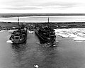 LST-822 and LST-1110.jpg 740 × 591; 89 KB
-
 Map of Distant Early Warning (DEW) Line.jpg 3000 × 1993; 3,38 MB
-
 Meeting plane on beach Nygren.jpg 1760 × 1156; 1,17 MB
-
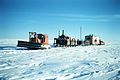 Moving camp Nygren.jpg 1732 × 1152; 1,05 MB
-
 Norseman Tigvariak 1949.jpg 1716 × 1148; 1,18 MB
-
 North American Air Defence Command radar map 1956.png 2059 × 1358; 999 KB
-
 Point Lay Alaska DEW Line.jpg 2820 × 1870; 1,8 MB
-
 Radar operators in EC-121K during Atlantic Barrier flight c1961.jpg 1079 × 1092; 837 KB
-
-
 Thule Bldg 4003 Rainbow.jpg 3744 × 2104; 1,93 MB
-
 USS Thomaston (LSD-28) in the Arctic in 1955.jpg 1026 × 440; 412 KB


.JPG)


_Station_-_Still_Remotely_Operated_-_Tuktoyaktuk_-_Northwest_Territories_-_Canada.jpg)


_Line.jpg)


_sponsored_by_the_109th_Airlift_Wing_(AW)_take_a_break_from_their_training._Students_take_part_in_a_4-day_schoo_-_DPLA_-_69abdaef22fe25afeb6a2580d5eb36f0.jpeg)

_in_the_Arctic_in_1955.jpg)