Category:Drot
Zur Navigation springen
Zur Suche springen
Français : Le Dropt (en occitan : Dròt) est une rivière du sud-ouest de la France et un affluent droit de la Garonne, en région Nouvelle-Aquitaine.
Deutsch: Der Dropt ist ein Fluss in Frankreich, der in der Region Nouvelle-Aquitaine verläuft.
English: The Dropt is a river in Nouvelle-Aquitaine, France. It is a right tributary to the Garonne.
Nebenfluss der Garonne  | |||||
| Medium hochladen | |||||
| Ist ein(e) | |||||
|---|---|---|---|---|---|
| Ort |
| ||||
| Länge |
| ||||
| Höhe über dem Meeresspiegel |
| ||||
| Mündet in | |||||
| Einzugsgebiet | |||||
| Nebenfluss |
| ||||
 | |||||
Unterkategorien
Es werden 4 von insgesamt 4 Unterkategorien in dieser Kategorie angezeigt:
In Klammern die Anzahl der enthaltenen Kategorien (K), Seiten (S), Dateien (D)
Medien in der Kategorie „Drot“
Folgende 47 Dateien sind in dieser Kategorie, von 47 insgesamt.
-
 24542-Soulaures-Sage.png 3.507 × 2.480; 914 KB
-
 Allemans-du-Dropt Dropt 01.jpg 2.576 × 1.932; 954 KB
-
 Allemans-du-Dropt Dropt 02.jpg 2.576 × 1.932; 1,45 MB
-
 Allemans-du-Dropt Dropt 03.jpg 2.576 × 1.932; 1,11 MB
-
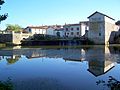
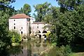
 Bagas Moulin 03.jpg 2.576 × 1.716; 1,38 MB
-
 Bagas Panneau Drot.jpg 2.057 × 517; 210 KB
-
 Bagas Pont Dropt.jpg 2.576 × 1.716; 1,6 MB
-
 Caudrot Confluent Drot Garonne.JPG 2.576 × 1.932; 1.023 KB
-
 De Dropt bij Monségur.JPG 3.072 × 2.304; 3,11 MB
-
 Dropt entre Falgueyrat et Queyrels amont.jpg 3.264 × 2.448; 2,86 MB
-
 Dropt entre Falgueyrat et Queyrels aval.jpg 3.264 × 2.448; 3,13 MB
-
 Dropt Eymet pont Bretou amont.JPG 3.264 × 2.448; 3,98 MB
-
 Dropt Eymet pont Bretou aval.JPG 3.264 × 2.448; 3,74 MB
-
 Dropt Eymet RD933 panneau.jpg 3.264 × 2.448; 3,03 MB
-
 Dropt Eymet.JPG 3.264 × 2.448; 2,58 MB
-
 Dropt La Sauvetat-du-Dropt vieux pont aval.JPG 3.264 × 2.448; 3,97 MB
-
 Dropt Monségur pôle nature amont (1).JPG 3.264 × 2.448; 4,01 MB
-
 Dropt Monségur pôle nature amont.JPG 3.264 × 2.448; 3,59 MB
-
 Dropt Monségur pôle nature aval.JPG 3.264 × 2.448; 3,84 MB
-
 Dropt vallée Gaugeac depuis château Saint-Germain (3).jpg 3.264 × 2.448; 4,79 MB
-
 Dropt vallée Gaugeac depuis château Saint-Germain (4).jpg 3.264 × 2.448; 1,79 MB
-
 Dropt vallée Gaugeac nord moulin Rouselle amont.jpg 3.191 × 2.393; 2,02 MB
-
 Dropt vallée Gaugeac nord moulin Rouselle aval.jpg 3.203 × 2.402; 2,49 MB
-
 Dropt vallée Gaugeac sud-ouest moulin de Serre amont.jpg 3.264 × 2.448; 2,04 MB
-
 Dropt vallée Gaugeac sud-ouest moulin de Serre aval (2).jpg 3.264 × 2.448; 2,77 MB
-
 Eymet Rouquette vallée Dropt (1).JPG 3.264 × 2.448; 3,92 MB
-
 Eymet Rouquette vallée Dropt.JPG 3.264 × 2.448; 3,63 MB
-
 La Sauvetat-du-Dropt - Pont gothique - vu de l'aval.JPG 2.015 × 1.269; 750 KB
-
 La Sauvetat-du-Dropt vieux pont (1).JPG 3.264 × 2.448; 3,88 MB
-
 La Sauvetat-du-Dropt vieux pont (2).JPG 3.264 × 2.448; 3,86 MB
-
 La Sauvetat-du-Dropt vieux pont (3).JPG 3.264 × 2.448; 3,78 MB
-
 La Sauvetat-du-Dropt vieux pont (4).JPG 3.264 × 2.448; 3,83 MB
-
 La Sauvetat-du-Dropt vieux pont aval.JPG 3.264 × 2.448; 3,97 MB
-
 La Sauvetat-du-Dropt vieux pont avant-bec (1).JPG 3.264 × 2.448; 3,87 MB
-
 La Sauvetat-du-Dropt vieux pont avant-bec.JPG 3.264 × 2.448; 3,96 MB
-
 La Sauvetat-du-Dropt vieux pont.JPG 3.264 × 2.448; 3,65 MB
-
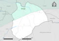
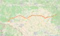 Le Dropt (tracé).png 960 × 576; 524 KB
-
 Le Dropt à Monségur (Gironde, Fr).JPG 3.072 × 2.304; 3,17 MB
-
 Le Puy 33 maïs (2).jpg 3.264 × 2.448; 2,38 MB
-
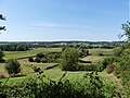 Le Puy 33 vallée Dropt (2).jpg 3.153 × 2.365; 1,67 MB
-
 Le Puy 33 vallée Dropt.jpg 3.264 × 2.448; 1,9 MB
-
 Loubens 33 Moulin 01.jpg 2.576 × 1.716; 1,77 MB
-
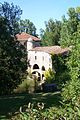 Loubens 33 Moulin 02.jpg 1.716 × 2.576; 1,53 MB
-
 Loubens.jpg 300 × 209; 46 KB
-
 Monségur 33 pôle nature (1).jpg 3.264 × 2.448; 3,21 MB
-
 Orchis laxiflora2.jpg 387 × 599; 54 KB
-
 Souleuret Gaugeac moulin Rousselle aval (1).jpg 3.139 × 2.354; 2,46 MB


.JPG)


.jpg)
.jpg)


.jpg)
.JPG)


.JPG)
.JPG)
.JPG)
.JPG)

.JPG)


.png)
.JPG)
.jpg)
.jpg)


.jpg)

.jpg)