Category:Dublin Area Rapid Transit
Vai alla navigazione
Vai alla ricerca
an electrified rapid transit railway network serving Dublin, Republic of Ireland   | |||||
| Carica un file multimediale | |||||
| Istanza di |
| ||||
|---|---|---|---|---|---|
| Luogo | Dublino, Irlanda | ||||
| Elemento operato |
| ||||
| Proprietario |
| ||||
| Operatore |
| ||||
| Data di apertura ufficiale |
| ||||
| Lunghezza |
| ||||
| Capolinea | |||||
| Deposito ferroviario | |||||
| Distinto da | |||||
| sito web ufficiale | |||||
| |||||
Sottocategorie
Questa categoria contiene le 14 sottocategorie indicate di seguito, su un totale di 14.
C
- CIÉ 8100 Class (78 F)
- Clongriffin railway station (6 F)
- Clontarf Road railway station (17 F)
D
F
- Fairview DART depot (3 F)
G
I
- IE 8200 Class (4 F)
- IÉ 8500, 8510 and 8520 Classes (48 F)
L
- Lansdowne Road railway station (16 F)
M
- Malahide railway station (61 F)
P
- Portmarnock railway station (7 F)
R
- Raheny railway station (26 F)
S
- Sandymount railway station (1 F)
File nella categoria "Dublin Area Rapid Transit"
Questa categoria contiene 35 file, indicati di seguito, su un totale di 35.
-
 05 982 Bf Dublin Conolly, ET 8305 DART.jpg 5 591 × 3 733; 3,03 MB
-
 15 609 Po xxxxxx, ET 8121 Ri Howth.jpg 5 595 × 3 725; 3,91 MB
-
 15 611 Bf Grand Canal Dock, ET 8116 Ri. Bray.jpg 5 571 × 3 733; 3,09 MB
-
 15 612 Bf Grand Canal Dock, ET 8107.jpg 5 591 × 3 746; 3,2 MB
-
 Westland Row, Dublin.jpg 2 560 × 1 920; 2,16 MB
-

-
 A DART train crossing Clontarf Road - geograph.org.uk - 2217143.jpg 1 024 × 768; 147 KB
-
 Bray head railway.jpg 4 592 × 3 056; 3,71 MB
-
 Commuters on their way to work with referendum billboard in the background (3973829859).jpg 4 272 × 2 848; 1,46 MB
-
 DART line at Booterstown - geograph.org.uk - 400930.jpg 640 × 480; 91 KB
-
 DART line at Dalkey looking north.JPG 3 072 × 1 728; 2,7 MB
-
 Dart Line between Bray and Greystones - geograph.org.uk - 1139622.jpg 480 × 640; 126 KB
-
 DART lines - geograph.org.uk - 458399.jpg 640 × 478; 90 KB
-
 Dart rounding Killiney Hill - geograph.org.uk - 1762084.jpg 640 × 480; 91 KB
-
 Dart Tara Station.jpg 1 024 × 768; 121 KB
-
 DART track length (km) at end of FY.png 2 895 × 2 028; 108 KB
-
 Dart+ Map Dublin.jpg 2 481 × 3 508; 1,62 MB
-
 Dart+ Map.svg 512 × 724; 30 KB
-
 DART-ontrain-illuminated-route-map.jpg 2 304 × 1 712; 1,81 MB
-
 DART01.JPG 3 264 × 2 448; 2,45 MB
-
 DART路線図.png 2 500 × 534; 222 KB
-
 DART路線地図.png 2 000 × 2 528; 736 KB
-
 Dublin Area Rapid Transit Logo.svg 512 × 136; 4 KB
-
 DUBLIN AREA RAPID TRANSIT.PNG 373 × 827; 12 KB
-
 Dublin Bus double-decker.jpg 768 × 576; 65 KB
-
 Greystones DART Station - geograph.org.uk - 1589146.jpg 640 × 480; 90 KB
-
 Howth Junction railway station in 2007.jpg 640 × 480; 114 KB
-
-
 Lord Cloncurry's bridge, near Blackrock, 2017.jpg 5 472 × 3 648; 8,78 MB
-
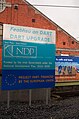 National Development Plan sign.jpg 1 168 × 1 760; 340 KB
-
 Raheny Railway (DART) Station (Ireland) - panoramio (6).jpg 6 000 × 4 000; 4,77 MB
-
 Sutton Level Crossing - geograph.org.uk - 458337.jpg 640 × 480; 119 KB
-
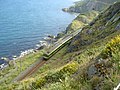 The DART passing around Bray Head - geograph.org.uk - 917332.jpg 640 × 480; 117 KB
-
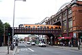
 The Loop Line, Dublin - geograph.org.uk - 1093425.jpg 640 × 405; 111 KB
-
 Today You Will Shine (91397505).jpeg 2 048 × 2 048; 565 KB


.jpg)


_at_end_of_FY.png)


_Station_(Ireland)_-_panoramio_(6).jpg)


.jpeg)