Category:Dunstall
Aller à la navigation
Aller à la recherche
English: Dunstall is a small village and civil parish in the borough of East Staffordshire, Staffordshire, England. It lies between Burton upon Trent and Barton-under-Needwood. The population of the parish at the 2001 census was 215.
localité britannique du comté anglais de Staffordshire  | |||||
| Téléverser des médias | |||||
| Nature de l’élément | |||||
|---|---|---|---|---|---|
| Lieu | East Staffordshire, Staffordshire, Midlands de l'Ouest, Angleterre | ||||
| À ne pas confondre avec | |||||
| Réputé identique à | Dunstall (page en doublon, paroisse civile) | ||||
 | |||||
Sous-catégories
Cette catégorie comprend 4 sous-catégories, dont les 4 ci-dessous.
Média dans la catégorie « Dunstall »
Cette catégorie comprend 110 fichiers, dont les 110 ci-dessous.
-
 Across a Field of Cattle to Mature Woodland - geograph.org.uk - 2609442.jpg 640 × 428 ; 66 kio
-
 Approaching Dunstall Cross on Forest Road - geograph.org.uk - 3931219.jpg 3 533 × 2 559 ; 4,84 Mio
-
 Approaching power lines crossing A38 - geograph.org.uk - 4564675.jpg 640 × 347 ; 45 kio
-
 Barton-under-Needwood turning A38 - geograph.org.uk - 2400270.jpg 640 × 418 ; 48 kio
-
 Brankley Farm - geograph.org.uk - 400887.jpg 640 × 427 ; 50 kio
-
 Bridge 36, Trent ^ Mersey Canal - geograph.org.uk - 6306177.jpg 1 600 × 1 200 ; 592 kio
-
 Bridleway past Springs Bank Farm - geograph.org.uk - 3376956.jpg 3 776 × 2 520 ; 4,05 Mio
-
 Bridleway through the woods - geograph.org.uk - 442119.jpg 640 × 480 ; 115 kio
-
 Bridleway to Dunstall - geograph.org.uk - 2617158.jpg 640 × 428 ; 115 kio
-
 Bridleway to Hill Farm - geograph.org.uk - 5236554.jpg 1 600 × 1 066 ; 372 kio
-
 Bus stop, Dunstall - geograph.org.uk - 198991.jpg 640 × 480 ; 86 kio
-
 Canal Milepost, Dunstall.jpg 1 024 × 767 ; 340 kio
-
 Closed - geograph.org.uk - 425626.jpg 640 × 480 ; 95 kio
-
 Concrete works near Barton-under-Needwood in Derbyshire - geograph.org.uk - 5050396.jpg 1 280 × 960 ; 878 kio
-
 Concrete works near Barton-under-Needwood in Derbyshire - geograph.org.uk - 5050399.jpg 1 440 × 1 440 ; 2,22 Mio
-
 Concrete works near Barton-under-Needwood in Derbyshire - geograph.org.uk - 5050403.jpg 1 280 × 960 ; 696 kio
-
 Crop near Branston - geograph.org.uk - 2983282.jpg 640 × 340 ; 48 kio
-
 Crossroads Near Barton Gate - geograph.org.uk - 969755.jpg 640 × 480 ; 63 kio
-
 Crossroads near Dunstall Cross - geograph.org.uk - 2617220.jpg 640 × 428 ; 48 kio
-
 Deanery Farm - geograph.org.uk - 400970.jpg 640 × 421 ; 81 kio
-
 Deanery Farm - geograph.org.uk - 402967.jpg 479 × 640 ; 182 kio
-
 Dunstall bridleway - geograph.org.uk - 3152137.jpg 3 264 × 2 448 ; 2,65 Mio
-
 Dunstall Cross - geograph.org.uk - 3555997.jpg 640 × 480 ; 67 kio
-
 Dunstall from the south - geograph.org.uk - 3387732.jpg 3 776 × 2 520 ; 3,88 Mio
-
 Dunstall Hall gateway - geograph.org.uk - 1912276.jpg 2 000 × 1 500 ; 933 kio
-
 Dunstall Hall, Dunstall - geograph.org.uk - 3443312.jpg 640 × 419 ; 167 kio
-
 Dunstall Park - geograph.org.uk - 1822377.jpg 1 024 × 768 ; 164 kio
-
 Dunstall village sign on Forest Road - geograph.org.uk - 5842783.jpg 1 469 × 1 102 ; 529 kio
-
 Dunstall, aerial 2018 - geograph.org.uk - 5841632.jpg 800 × 533 ; 103 kio
-
 Dunstall, Boxing Day 2004 - geograph.org.uk - 356412.jpg 640 × 480 ; 139 kio
-
 Dunstall, Staffordshire, St Mary - geograph.org.uk - 5916227.jpg 4 608 × 3 456 ; 4,02 Mio
-
 Dunstallcc.jpg 500 × 375 ; 16 kio
-
 Electricity Pylons at Woodside Farm - geograph.org.uk - 3931215.jpg 2 858 × 3 701 ; 4,49 Mio
-
 End of the footpath - geograph.org.uk - 865970.jpg 640 × 480 ; 149 kio
-
 Entrance to Dunstall Hall, Dunstall - geograph.org.uk - 2608979.jpg 640 × 428 ; 103 kio
-
 Farmland near Dunstall Cross - geograph.org.uk - 3555239.jpg 640 × 480 ; 60 kio
-
 Farmland towards the A38 - geograph.org.uk - 3407360.jpg 640 × 499 ; 45 kio
-
 Female occ 1881.jpg 1 161 × 601 ; 33 kio
-
 Fernhill Farm on the Dunstall Estate - geograph.org.uk - 2617197.jpg 640 × 428 ; 61 kio
-
 Footpath down to the Old School House - geograph.org.uk - 5236542.jpg 1 600 × 1 066 ; 497 kio
-
 Footpath near Woodlane - geograph.org.uk - 402917.jpg 480 × 640 ; 126 kio
-
 Footpath to Barton-under-Needwood - geograph.org.uk - 2608953.jpg 428 × 640 ; 86 kio
-
 Footpath to Barton-under-Needwood - geograph.org.uk - 2617140.jpg 428 × 640 ; 128 kio
-
 Forest Road north towards Dunstall Cross - geograph.org.uk - 5842779.jpg 1 142 × 857 ; 466 kio
-
 Gravel pit at Dunstall 1 - geograph.org.uk - 865980.jpg 640 × 317 ; 63 kio
-
 Gravel pit at Dunstall 2 - geograph.org.uk - 865985.jpg 640 × 480 ; 96 kio
-
 Green as grass - geograph.org.uk - 425630.jpg 640 × 480 ; 85 kio
-
 Growing fast - geograph.org.uk - 425619.jpg 640 × 480 ; 93 kio
-
 Hedge and houses near Sherholt - geograph.org.uk - 5236482.jpg 1 600 × 1 066 ; 520 kio
-
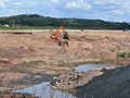
 Land stripped for gravel extraction - geograph.org.uk - 865974.jpg 640 × 480 ; 88 kio
-
 Land turned over to a Plantation of Trees - geograph.org.uk - 2608938.jpg 640 × 428 ; 83 kio
-
 Lane Near Forest Thorn - geograph.org.uk - 969749.jpg 640 × 480 ; 78 kio
-
 Looking across Parkland, Dunstall - geograph.org.uk - 2608967.jpg 640 × 428 ; 99 kio
-
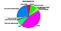 Male occ 1881.jpg 1 161 × 601 ; 51 kio
-
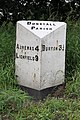 Milepost, Lichfield Road, Dunstall.jpg 533 × 800 ; 94 kio
-

-
 Narrowboat near Tatenhill Lock, Dunstall, Staffordshire.jpg 640 × 457 ; 148 kio
-
 Near Dunstall - geograph.org.uk - 4455983.jpg 4 320 × 3 240 ; 6,57 Mio
-
 Near Sherholt Lodge - geograph.org.uk - 969761.jpg 640 × 480 ; 66 kio
-
 North along the towpath of the Trent ^ Mersey Canal - geograph.org.uk - 4544665.jpg 1 024 × 738 ; 299 kio
-
 Oak by the footpath - geograph.org.uk - 865978.jpg 640 × 480 ; 100 kio
-
 Oak tree at Dunstall - geograph.org.uk - 738064.jpg 426 × 640 ; 98 kio
-
 Oak-lined lane, Whitewood. - geograph.org.uk - 402937.jpg 640 × 480 ; 236 kio
-
 Old Hall with The Black Firs beyond - geograph.org.uk - 5236545.jpg 1 600 × 1 066 ; 413 kio
-
 Old Hall, Dunstall - geograph.org.uk - 3387716.jpg 3 776 × 2 520 ; 3,82 Mio
-
 Parkland at Dunstall Hall - geograph.org.uk - 865956.jpg 640 × 480 ; 85 kio
-
 Parkland cattle - geograph.org.uk - 1822354.jpg 1 024 × 768 ; 119 kio
-
 Parkland off Dunstall Road - geograph.org.uk - 1822363.jpg 1 024 × 768 ; 136 kio
-
 Path to Black Meadow Wood - geograph.org.uk - 865975.jpg 640 × 480 ; 126 kio
-
 Picket - geograph.org.uk - 425613.jpg 640 × 480 ; 94 kio
-
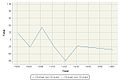 Population Change in Dunstall between 1880 and 1960.jpg 600 × 400 ; 31 kio
-
 Possible route of Via Devana - geograph.org.uk - 5214766.jpg 640 × 480 ; 95 kio
-
 Power lines crossing A38 - geograph.org.uk - 4565967.jpg 640 × 366 ; 50 kio
-
 Powerlines heading to Dunstall Cross - geograph.org.uk - 5236490.jpg 1 600 × 1 066 ; 452 kio
-
 Road past Dunstall Hall with the church in the distance - geograph.org.uk - 5236556.jpg 1 600 × 1 066 ; 442 kio
-
 Sand and gravel processing plant, Staffordshire - geograph.org.uk - 1552647.jpg 640 × 455 ; 126 kio
-
 Sand and gravel processing plant, Staffordshire - geograph.org.uk - 1552651.jpg 640 × 640 ; 167 kio
-
 Scotch Hills Lane towards Forest Thorn - geograph.org.uk - 5236494.jpg 1 600 × 1 066 ; 560 kio
-
 Scruffy trackside growth - geograph.org.uk - 6205871.jpg 2 000 × 1 330 ; 1,34 Mio
-
 Side Entrance to Home Farm, Dunstall - geograph.org.uk - 2608963.jpg 640 × 428 ; 83 kio
-
 St Mary's Church - geograph.org.uk - 5236551.jpg 1 600 × 1 066 ; 267 kio
-
 St Mary's Dunstall - geograph.org.uk - 4455979.jpg 4 286 × 3 196 ; 6,43 Mio
-
 Stoneyford - geograph.org.uk - 402911.jpg 640 × 480 ; 98 kio
-
 Tatenhill Lock - geograph.org.uk - 6306175.jpg 1 600 × 1 200 ; 392 kio
-
 The 'main road' through Dunstall - geograph.org.uk - 1822328.jpg 1 024 × 768 ; 217 kio
-
 The A38 and the Dunstall Parish milepost in its setting - geograph.org.uk - 3748492.jpg 1 142 × 857 ; 666 kio
-
 The Church of St Mary at Dunstall - geograph.org.uk - 5053914.jpg 4 000 × 3 000 ; 2,66 Mio
-
 The Dunstall Parish milepost - detail - geograph.org.uk - 3748489.jpg 857 × 1 142 ; 756 kio
-
 The Home Farm, Dunstall - geograph.org.uk - 1912260.jpg 2 000 × 1 480 ; 587 kio
-
 The old and the new - geograph.org.uk - 442108.jpg 640 × 480 ; 68 kio
-
 The Park of Dunstall Hall - geograph.org.uk - 5236561.jpg 1 600 × 1 066 ; 576 kio
-
 The River Trent - geograph.org.uk - 4648432.jpg 4 000 × 3 000 ; 2,91 Mio
-
 The River Trent at Tucklesholme Quarry - geograph.org.uk - 4648425.jpg 4 000 × 3 000 ; 2,26 Mio
-
 The Road to Tatenhill - geograph.org.uk - 2609452.jpg 640 × 428 ; 74 kio
-
 Transmission lines near Barton Gate - geograph.org.uk - 402965.jpg 640 × 471 ; 87 kio
-
 Trent ^ Mersey Canal - geograph.org.uk - 6306176.jpg 1 600 × 1 200 ; 455 kio
-
 Victorian letter box, Dunstall - geograph.org.uk - 1912293.jpg 2 000 × 1 500 ; 813 kio
-
 View along possible Via Devana - geograph.org.uk - 5214796.jpg 4 896 × 3 672 ; 6,97 Mio
-
 View along route of possible Via Devana - geograph.org.uk - 5214827.jpg 4 896 × 3 672 ; 6,78 Mio
-
 View east from Dunstall Road. - geograph.org.uk - 865992.jpg 640 × 480 ; 125 kio
-
 Village Hall, Dunstall.jpg 1 600 × 1 066 ; 425 kio
-
 Winter hedgerow - geograph.org.uk - 5236483.jpg 1 600 × 1 066 ; 535 kio
-
 Wood sculpture by the Trent and Mersey Canal - geograph.org.uk - 2664378.jpg 1 080 × 1 426 ; 2,1 Mio
-
 Woods on the Dunstall estate - geograph.org.uk - 400953.jpg 640 × 421 ; 55 kio
-
 Bridge over Lin Brook - geograph.org.uk - 308271.jpg 640 × 480 ; 158 kio
-
 Dunstall Cross - geograph.org.uk - 198913.jpg 640 × 480 ; 73 kio
-
 Footpath junction - geograph.org.uk - 436953.jpg 640 × 480 ; 98 kio
-
 House in Needwood Forest - geograph.org.uk - 198898.jpg 640 × 480 ; 65 kio
-

-
 Plantation and field at Scotch Hill - geograph.org.uk - 198899.jpg 480 × 640 ; 104 kio


