Category:Dust Bowl
Salti al navigilo
Salti al serĉilo
English: The Dust Bowl refers to the environmental conditions and economic difficulties on the American Great Plains during the 1930s.
- A severe drought created massive topsoil erosion and dust storms, and coupled with the Great Depression, resulted in a mass exodus of Migrants out of the Great Plains region.
period of severe dust storms in North America  | |||||
| Alŝuti plurmedion | |||||
| Estas | |||||
|---|---|---|---|---|---|
| Loko |
| ||||
| Havas parton | |||||
| Ekde |
| ||||
| Ĝis |
| ||||
| |||||
Subkategorioj
Ĉi tiu kategorio havas la 7 jenajn subkategoriojn, el 7 entute.
Dosieroj en kategorio “Dust Bowl”
La jenaj 68 dosieroj estas en ĉi tiu kategorio, el 68 entute.
-
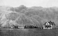
 Dust Storms, "Dust Storm Near Beaver, Oklahoma" - NARA - 195354.tif 2 000 × 1 171; 2,25 MB
-

-
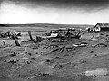
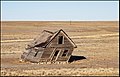
 Abandoned Dust Bowl Home - Dorothea Lange.jpg 4 270 × 3 286; 19,03 MB
-
-
 An early use of contour farming during the Dust Bowl, NRCSDC01010.jpg 2 100 × 1 440; 286 KB
-
 Cultivating cotton on a farm during the Dust Bowl, NRCSDC01002.jpg 2 100 × 1 440; 258 KB
-
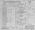
 Daily News (Los Angeles), Volume 12, Number 192, 13 April 1935 - page 1.jpg 4 504 × 6 890; 6,85 MB
-
 Dorothea Lange - Migrant Family in Salinas, CA.tif 4 856 × 5 112, 2 paĝoj; 47,37 MB
-
 Dorothealange color 21.jpg 400 × 400; 136 KB
-
 Dorothealange color 8b27011a.jpg 400 × 400; 92 KB
-
 Dorothealange color 8b35311a.jpg 400 × 400; 115 KB
-
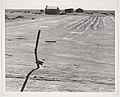
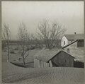
 Dust Bowl - Dallas, South Dakota 1936.jpg 2 400 × 1 800; 1,07 MB
-
 Dust Bowl Existing Condition 05-2021.jpg 2 016 × 1 512; 743 KB
-
 Dust Bowl farm, Coldwater District, north of Dalhart, Texas, 8b32396a.tif 10 011 × 7 601; 145,2 MB
-
 Dust Bowl farm. Coldwater District, north of Dalhart, Texas.jpg 9 186 × 7 051; 23,86 MB
-
 Dust Bowl in Texas County, Oklahoma.jpg 1 600 × 1 265; 421 KB
-
 Dust Bowl winds pile up against barn in Kansas.jpg 6 082 × 6 012; 8,13 MB
-
 Dust bowl, Texas Panhandle, TX fsa.8b27276 edit.jpg 7 481 × 5 569; 23,9 MB
-
 Dust bowl, Texas Panhandle, TX fsa.8b27276 negative.jpg 3 740 × 2 785; 5,46 MB
-
 Dust bowl, Texas Panhandle, TX fsa.8b27276 original.tif 8 468 × 6 296; 101,69 MB
-
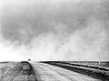
 Dust storm approaching Stratford, Texas.jpg 3 248 × 2 028; 1,85 MB
-
 Dust Storm in Rolla, Kansas 05-06-35 (4546091662).jpg 3 000 × 1 835; 419 KB
-

-
 Dust storm in Spearman,Texas, 1935-04-14.jpg 2 048 × 1 152; 180 KB
-
 Dust storm in Spearman,Texas, Wea01422.jpg 700 × 525; 130 KB
-
 Dust Storm Texas 1935.jpg 3 364 × 2 196; 1,81 MB
-
 Dust Storm, "Dust Storm Approaching Spearman, Texas." - NARA - 196033.tif 2 000 × 1 528; 2,94 MB
-

-

-
 Dust Storms, "One of South Dakota's Black Blizzards, 1934" - NARA - 195304.tif 2 000 × 1 250; 2,4 MB
-
 Dust Storms, Turtle Studio, "Dust Storm in Liberal, Kansas" - NARA - 195355.tif 2 000 × 1 426; 2,74 MB
-
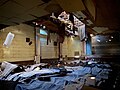
 Dust-Bowl-Theater-Eloy-2020-Schwann-Hanns.jpg 3 024 × 4 032; 5,64 MB
-
 Dust-storm-Texas-1935 (cropped).png 1 022 × 730; 1,56 MB
-
 Dust-storm-Texas-1935.png 1 200 × 730; 1,03 MB
-

-
 Heavy black clouds of dust rising over the Texas Panhandle, Texas, 8b27277a.jpg 7 488 × 5 616; 17,03 MB
-
 Heavy black clouds of dust rising over the Texas Panhandle, Texas, 8b27277a.tif 8 628 × 6 344; 104,45 MB
-
 Heavy black clouds of dust rising over the Texas Panhandle, Texas.jpg 8 479 × 6 902; 4,99 MB
-
 Keota, Colorado Dust Bowl2.png 556 × 420; 110 KB
-
 Keota, Colorado Dust Bowl3.png 550 × 420; 110 KB
-
 Keota, Colorado, 8b18577.jpg 12 792 × 9 560; 41,42 MB
-
 Keota, Colorado, 8b18577a.tif 13 917 × 10 774; 286,11 MB
-

-

-
 Migrant Family in Salinas, CA.jpg 4 192 × 4 413; 8,08 MB
-
 Migrants in Muskogee County, Oklahoma 1938.jpg 938 × 1 024; 272 KB
-
 Mills, NM in 2020. There were better days.jpg 2 027 × 1 303; 2,51 MB
-

-

-

-
 Oklahoma dust bowl refugees, San Fernando, California, 8b27316.jpg 3 514 × 2 636; 1,89 MB
-
 Oklahoma dust bowl refugees, San Fernando, California, 8b27316.tif 1 536 × 1 040; 1,53 MB
-
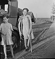 OklahomaChildrenCrutches1935Lange.jpg 4 018 × 4 344; 6,55 MB
-
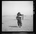
 Oklahoman boy during the Dust Bowl era.jpg 4 123 × 3 474; 6,95 MB
-

-
 Severely eroded farmland during the Dust Bowl, NRCSDC01018.jpg 2 100 × 1 440; 257 KB
-
 Soil blown by dust bowl winds piled up in large drifts on a farm, 01322u.tif 6 082 × 6 012; 104,64 MB
-
 Soil Erosion - NARA - 195526.tif 2 000 × 1 607; 3,09 MB
-
 Soil Erosion - NARA - 195527.tif 2 000 × 1 438; 2,77 MB
-
 Son of farmer in dust bowl area, Cimarron County, Oklahoma, 8b38282, original.jpg 4 286 × 4 228; 4,08 MB
-
 Son of farmer in dust bowl area, Cimarron County, Oklahoma, 8b38282.jpg 4 123 × 3 322; 3,09 MB
-
 Son of farmer in dust bowl area, Cimarron County, Oklahoma, 8b38282.tif 4 952 × 4 720; 44,62 MB
-
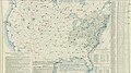 U.S. Weather Bureau Surface Analysis at 7-00 am CST on April 13, 1935.jpg 1 891 × 1 057; 406 KB
-
 U.S. Weather Bureau Surface Analysis at 7-00 am CST on April 14, 1935.jpg 1 891 × 1 058; 393 KB
-
 U.S. Weather Bureau Surface Analysis at 7-00 am CST on April 15, 1935.jpg 1 888 × 1 057; 411 KB
-
 US weather bureau, Beaver, OK, April 1935.png 960 × 818; 1,01 MB
-
 US weather bureau, Kenton, OK, April 1935.png 960 × 820; 1,01 MB
-
 Wind erosion carries topsoil from farmland during the Dust Bowl, NRCSDC01008.jpg 2 100 × 1 440; 158 KB


,_Volume_12,_Number_192,_13_April_1935_-_page_1.jpg)


.jpg)


.png)


.svg)
.svg)


