Category:East Horndon
Aller à la navigation
Aller à la recherche
English: East Horndon is a village in the south of the Brentwood borough of Essex and in the East of England. It is situated just south of the A127 road near Herongate. The village church is located to the north of the A127, and is disused.
village britannique  | |||||
| Téléverser des médias | |||||
| Nature de l’élément | |||||
|---|---|---|---|---|---|
| Lieu | West Horndon, Brentwood, Essex, Angleterre de l'Est, Angleterre | ||||
 | |||||
Sous-catégories
Cette catégorie comprend seulement la sous-catégorie ci-dessous.
A
- All Saints Church, East Horndon (24 F)
Média dans la catégorie « East Horndon »
Cette catégorie comprend 32 fichiers, dont les 32 ci-dessous.
-
 A128 to A127 Byway - geograph.org.uk - 51807.jpg 482 × 640 ; 143 kio
-
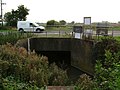 Blue House Culvert - geograph.org.uk - 51798.jpg 640 × 482 ; 88 kio
-
 Byway and A128 - geograph.org.uk - 51802.jpg 482 × 640 ; 108 kio
-
 Dunton Hills Farm - geograph.org.uk - 51815.jpg 640 × 436 ; 50 kio
-
 East horndon petrol station.jpg 680 × 453 ; 245 kio
-
East Horndon.ogg 1,4 s ; 15 kio
-
 Elliots nightclub 2009.jpg 680 × 522 ; 294 kio
-

-
 Pylon by the railway line - geograph.org.uk - 3804875.jpg 640 × 430 ; 41 kio
-
 Pylon by the railway line - geograph.org.uk - 4441543.jpg 640 × 430 ; 39 kio
-
 Pylon seen over the tree tops - geograph.org.uk - 3804876.jpg 640 × 430 ; 39 kio
-
 Railway bridge over A128 - geograph.org.uk - 2867740.jpg 640 × 428 ; 88 kio
-
 Railway bridge over A128 at Barnards - geograph.org.uk - 5989194.jpg 1 024 × 768 ; 136 kio
-
 Wick Place and the A128 - geograph.org.uk - 52128.jpg 640 × 482 ; 68 kio
-
 Wick Place Telecom's Tower - geograph.org.uk - 51784.jpg 482 × 640 ; 66 kio
-
 A shaded entrance - geograph.org.uk - 164019.jpg 640 × 480 ; 117 kio
-
 A view of Noke Hall Farm from Doesgate Lane - geograph.org.uk - 686607.jpg 640 × 367 ; 75 kio
-
 A view of Nutty's Farm from Childerditch Lane - geograph.org.uk - 689817.jpg 640 × 379 ; 62 kio
-
 Brentwood Rd - geograph.org.uk - 51788.jpg 640 × 482 ; 80 kio
-
 China Lane - geograph.org.uk - 52121.jpg 640 × 482 ; 124 kio
-
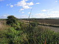 Drainage Ditch, Blue House Farm, West Horndon - geograph.org.uk - 59783.jpg 640 × 480 ; 121 kio
-
 Dunnings Lane - geograph.org.uk - 52122.jpg 640 × 482 ; 71 kio
-
 Field Drain at Blue House Farm - geograph.org.uk - 60048.jpg 640 × 482 ; 123 kio
-
 Field House Farm - geograph.org.uk - 52119.jpg 640 × 482 ; 92 kio
-
 Part of Dunnings Lane - geograph.org.uk - 689843.jpg 640 × 427 ; 73 kio
-
 Part of East Horndon - geograph.org.uk - 689854.jpg 640 × 399 ; 45 kio
-
 Railway Line, West Horndon, Essex - geograph.org.uk - 22370.jpg 640 × 480 ; 125 kio
-

-
 Stile, Childerditch Street, Brentwood, Essex - geograph.org.uk - 16985.jpg 640 × 480 ; 134 kio
-

-
 Thorndon Country Park South, Brentwood - geograph.org.uk - 420873.jpg 640 × 480 ; 90 kio
-
 Thorndon Country Park South, Brentwood - geograph.org.uk - 420876.jpg 640 × 480 ; 106 kio


,_Brentwood,_Essex_-_geograph.org.uk_-_22873.jpg)

