Category:Edstone
Aller à la navigation
Aller à la recherche
localité britannique du comté anglais de North Yorkshire  | |||||
| Téléverser des médias | |||||
| Nature de l’élément | |||||
|---|---|---|---|---|---|
| Lieu | Ryedale, Yorkshire du Nord, Yorkshire-et-Humber, Angleterre | ||||
 | |||||
English: Edstone is a civil parish in the Ryedale district of the county of North Yorkshire, England.
Sous-catégories
Cette catégorie comprend seulement la sous-catégorie ci-dessous.
G
Média dans la catégorie « Edstone »
Cette catégorie comprend 48 fichiers, dont les 48 ci-dessous.
-
 A bridleway to Little Edstone Farm - geograph.org.uk - 2661198.jpg 800 × 600 ; 363 kio
-
 A bridleway to Marton - geograph.org.uk - 2658094.jpg 800 × 600 ; 300 kio
-
 A path to Edstone Hill - geograph.org.uk - 2661189.jpg 800 × 600 ; 345 kio
-
 A walk from Pickering ^58 - geograph.org.uk - 2042980.jpg 800 × 600 ; 219 kio
-
 A walk from Pickering ^59 - geograph.org.uk - 2043000.jpg 800 × 600 ; 182 kio
-
 A walk from Pickering ^60 - geograph.org.uk - 2043011.jpg 800 × 600 ; 192 kio
-
 A walk from Pickering ^61 - geograph.org.uk - 2043025.jpg 800 × 600 ; 272 kio
-
 A walk from Pickering ^62 - geograph.org.uk - 2043041.jpg 800 × 600 ; 270 kio
-
 A walk from Pickering ^63 - geograph.org.uk - 2043057.jpg 800 × 600 ; 304 kio
-
 A walk from Pickering ^64 - geograph.org.uk - 2043077.jpg 800 × 600 ; 351 kio
-
 Across the fields to Innisfree - geograph.org.uk - 2432682.jpg 2 048 × 1 536 ; 671 kio
-
 Across the fields to Kirkbymoorside - geograph.org.uk - 2432686.jpg 1 024 × 768 ; 353 kio
-
 Brecklands - geograph.org.uk - 2453520.jpg 1 600 × 1 180 ; 292 kio
-
 Bridleway near Seven Oaks Farm - geograph.org.uk - 4826415.jpg 1 600 × 1 200 ; 534 kio
-
 Coulson Park Farm - geograph.org.uk - 2432722.jpg 2 048 × 1 536 ; 927 kio
-
 Country road - geograph.org.uk - 4734726.jpg 640 × 480 ; 29 kio
-
 Edstone Hill - geograph.org.uk - 1150627.jpg 640 × 314 ; 50 kio
-
 Edstone Hill - geograph.org.uk - 2432730.jpg 1 024 × 768 ; 299 kio
-
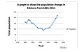 Edstone population graph from 1881-2011.jpg 640 × 400 ; 21 kio
-
 Farmland near Marton Common Farm - geograph.org.uk - 2453506.jpg 1 600 × 1 200 ; 410 kio
-
 Farmland towards Innisfree - geograph.org.uk - 2453497.jpg 1 600 × 1 200 ; 419 kio
-
 Farmland view from Great Edstone - geograph.org.uk - 2434555.jpg 2 048 × 1 536 ; 1,03 Mio
-
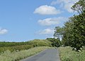
 Great Edstone Road - geograph.org.uk - 5233560.jpg 640 × 480 ; 138 kio
-
 Great Edstone, Pinfold - geograph.org.uk - 4546813.jpg 800 × 534 ; 159 kio
-
 Green fields and blue hills - geograph.org.uk - 2435391.jpg 2 048 × 1 184 ; 273 kio
-
 Green Lane, Marton - geograph.org.uk - 5341857.jpg 1 024 × 768 ; 227 kio
-
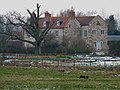 Little Edstone - geograph.org.uk - 1150620.jpg 640 × 480 ; 102 kio
-
 Little Edstone Farm - geograph.org.uk - 2453508.jpg 1 600 × 1 200 ; 304 kio
-
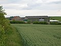 Marton Common Farm - geograph.org.uk - 2453504.jpg 1 600 × 1 200 ; 322 kio
-
 Marton Common Farm - geograph.org.uk - 5343781.jpg 1 024 × 768 ; 193 kio
-
 Minor road towards Salton - geograph.org.uk - 2453517.jpg 1 600 × 1 200 ; 405 kio
-
 Near Cartoft - geograph.org.uk - 6431753.jpg 640 × 480 ; 102 kio
-
 Near Cowldyke Farm - geograph.org.uk - 5233576.jpg 640 × 480 ; 152 kio
-
 Near Great Edstone - geograph.org.uk - 6431768.jpg 640 × 480 ; 123 kio
-
 New footpath sign - geograph.org.uk - 2432691.jpg 1 024 × 745 ; 268 kio
-
 Road from Great Edstone - geograph.org.uk - 2432625.jpg 2 048 × 1 536 ; 878 kio
-
 Road junction near Little Edstone - geograph.org.uk - 2435063.jpg 2 048 × 1 423 ; 412 kio
-
 Road south of Great Edstone - geograph.org.uk - 5233573.jpg 640 × 480 ; 115 kio
-
 The road to Salton - geograph.org.uk - 2432857.jpg 708 × 1 024 ; 366 kio
-
 Track to Cowldyke Farm (bridleway) - geograph.org.uk - 2453516.jpg 1 600 × 1 200 ; 489 kio
-
 Track to Great Edstone - geograph.org.uk - 1150609.jpg 640 × 480 ; 128 kio
-
 View from the eastern edge of Great Edstone - geograph.org.uk - 2432903.jpg 2 048 × 1 227 ; 620 kio
-
 View SE from the SE corner of Great Edstone - geograph.org.uk - 2434524.jpg 2 048 × 1 536 ; 837 kio
-
 View to Edstone Hill - geograph.org.uk - 2435395.jpg 2 048 × 1 340 ; 415 kio
-
 View to Kirkbymoorside from Great Edstone - geograph.org.uk - 2435002.jpg 1 024 × 599 ; 283 kio
-
 Wandles Farm - geograph.org.uk - 2453515.jpg 1 600 × 1 200 ; 207 kio
-
 Wind turbine at Sinnington Common Farm - geograph.org.uk - 2435007.jpg 1 600 × 1 139 ; 379 kio
-
 Entrance to Cowldyke Farm - geograph.org.uk - 204381.jpg 640 × 480 ; 110 kio


_-_geograph.org.uk_-_2453516.jpg)


