Category:Eifelkreis Bitburg-Prüm
Salti al navigilo
Salti al serĉilo
Urban districts (cities): Frankenthal · Kaiserslautern · Koblenz · Landau in der Pfalz · Ludwigshafen am Rhein · Mainz · Neustadt an der Weinstraße · Pirmasens · Speyer · Trier · Worms · Zweibrücken
distrikto de Rejnlando-Palatinato en Germanio    | |||||
| Alŝuti plurmedion | |||||
| Estas |
| ||||
|---|---|---|---|---|---|
| Loko | Rejnlando-Palatinato, Germanio | ||||
| Ĉefurbo | |||||
| Loĝantaro |
| ||||
| Areo |
| ||||
| Supermara alteco |
| ||||
| oficiala retejo | |||||
 | |||||
Deutsch: Der Eifelkreis Bitburg-Prüm (bis 31. Dezember 2006 Landkreis Bitburg-Prüm) ist ein deutscher Landkreis in Rheinland-Pfalz
Subkategorioj
Ĉi tiu kategorio havas la 31 jenajn subkategoriojn, el 31 entute.
B
N
S
- Sauertalradweg (4 D)
V
- Verbandsgemeinde Irrel (4 D)
- Verbandsgemeinde Kyllburg (2 D)
- Verbandsgemeinde Neuerburg (3 D)
Paĝoj en kategorio “Eifelkreis Bitburg-Prüm”
Ĉi tiu kategorio enhavas nur la jenan paĝon.
Dosieroj en kategorio “Eifelkreis Bitburg-Prüm”
La jenaj 35 dosieroj estas en ĉi tiu kategorio, el 35 entute.
-
 101 Paul Lentes, Concert-mémoire MemoShoah 2015.jpg 1 845 × 1 840; 1,62 MB
-
 Across the Kyll from Erdorf (2006) - panoramio (1).jpg 1 477 × 1 000; 273 KB
-
 Altes Zollhaus in de avond - panoramio.jpg 3 888 × 2 592; 3,38 MB
-
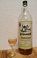 Baldi.jpg 1 577 × 2 467; 2,42 MB
-
 Beim Archehof "Hubertusblick" - geo.hlipp.de - 6181.jpg 640 × 480; 123 KB
-
 BIT in Rheinland-Pfalz.svg 574 × 744; 133 KB
-
 Bitburg - LRA v NW.jpg 4 000 × 2 248; 2,83 MB
-
 CIL-XIII-4143-Hettner.jpg 1 293 × 2 088; 786 KB
-
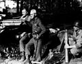 Ernest Hemingway and Buck Lanham, 1944.jpg 760 × 598; 295 KB
-

-
 Falkenstein Germany Ferraris 1777.png 636 × 762; 767 KB
-
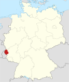
 Lage des Eifelkreises Bitburg-Prüm in Deutschland.png 197 × 235; 3 KB
-
 Lekker wat drinken op een gezellig terras - panoramio.jpg 3 888 × 2 592; 3,75 MB
-
 Locator map BIT in Germany.svg 1 075 × 1 273; 513 KB
-
 Locator map BIT in Rhineland-Palatinate.svg 708 × 913; 626 KB
-
 Lünebach im Winter 2010 - panoramio.jpg 9 458 × 2 323; 2,28 MB
-
 Mahnmal - panoramio (2).jpg 3 648 × 2 736; 2,47 MB
-
 Neuerburg (Karte des Deutschen Reiches, 502. Neuerburg) - urn-nbn-de-0128-1-12740.jpg 5 613 × 4 417; 6,19 MB
-
 Rhineland p bit.png 419 × 503; 13 KB
-
 Strassenbaustelle, Sinspelt (Road Works) - geo.hlipp.de - 22392.jpg 640 × 480; 93 KB
-
 Strohballen am Laarberg - geo.hlipp.de - 6131.jpg 640 × 480; 84 KB
-
Trierweiler-ahlenBrouch.ogv 3 min 10 s, 640 × 480; 6,92 MB
-
Trierweiler-haendler.ogv 5 min 41 s, 640 × 480; 13,92 MB
-
Trierweiler-heimat.ogv 2 min 2 s, 640 × 480; 6,88 MB
-
 Tussen Büdesheim en Prüm, panorama 2008-05-01 15.58.JPG 3 072 × 2 304; 1,89 MB
-
Video Kraeutergarten Trierweiler Roscheiderhof H1a.ogv 3 min 30 s, 640 × 480; 22,8 MB
-
 Wald nahe Achtfeld (Woodland near Achtfeld) - geo.hlipp.de - 23426.jpg 640 × 480; 139 KB
-
 Waldhof-falkenstein 01 ferraris.png 1 279 × 785; 1,81 MB
-
 Waldweg beim Schneifelhoehenweg - geo.hlipp.de - 6222.jpg 640 × 480; 135 KB
-

-
 Wanderparkplatz Nr.5 am Kettenkreuz - geo.hlipp.de - 6185.jpg 640 × 480; 136 KB
-
 Wanderweg - panoramio (34).jpg 3 648 × 2 736; 2,43 MB
-
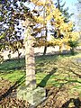 Wegkreuz, Harspelt - geo.hlipp.de - 6768.jpg 480 × 640; 166 KB
-
 Wegweiser suedlich von Harspelt - geo.hlipp.de - 6769.jpg 640 × 480; 151 KB
-
 Zum "Hubertusblick" - geo.hlipp.de - 6179.jpg 640 × 480; 131 KB

_-_panoramio_(1).jpg)


_Lanham_September_18,_1944_-_NARA_-_192699.jpg)


.jpg)
_-_urn-nbn-de-0128-1-12740.jpg)

_-_geo.hlipp.de_-_22392.jpg)


_-_geo.hlipp.de_-_23426.jpg)


_-_geo.hlipp.de_-_23393.jpg)

.jpg)


