Category:Escalante Desert
Vai alla navigazione
Vai alla ricerca
desert plain in Millard, Beaver, and Iron counties in Utah, United States .jpg) | |||||
| Carica un file multimediale | |||||
| Istanza di | |||||
|---|---|---|---|---|---|
| Parte di | |||||
| Luogo |
| ||||
| Altezza sul mare |
| ||||
 | |||||
English: The Escalante Desert — of the Great Basin region of Utah.
- In Iron and Beaver Counties, Utah.
Sottocategorie
Questa categoria contiene le 11 sottocategorie indicate di seguito, su un totale di 11.
File nella categoria "Escalante Desert"
Questa categoria contiene 5 file, indicati di seguito, su un totale di 5.
-
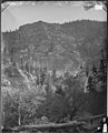 ALUM COVE, PAROWAN CANYON OR PAROVAN LEFTFORK, UTAH - NARA - 524366.jpg 2 420 × 3 000; 4,19 MB
-
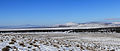 Escalante Desert (20130116 0747).jpg 1 652 × 700; 490 KB
-
 Lund Highway, Utah. West to Lund.jpg 1 000 × 667; 318 KB
-
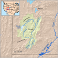 Sevierrivermap.png 500 × 500; 405 KB
-
 West of Milford, Utah - Flickr - brewbooks (1).jpg 3 264 × 2 448; 2,25 MB


.jpg)
Categorie:
- Deserts of Utah
- Great Basin region of Utah
- Valleys of the Great Basin in Utah
- Landforms of Iron County, Utah
- Landforms of Beaver County, Utah
- Locations along Utah State Route 16 (1935-1955)
- Locations along Utah State Route 19 (1927-1969)
- Locations along Utah State Route 18 in Iron County, Utah
- Locations along Utah State Route 56
- Locations along Utah State Route 130
- Locations along Utah State Route 257
- Locations along the Lund Highway