Category:Escambia County, Florida
Vai alla navigazione
Vai alla ricerca
Counties of Florida: Alachua · Baker · Bay · Bradford · Brevard · Broward · Calhoun · Charlotte · Citrus · Clay · Collier · Columbia · DeSoto · Dixie · Duval · Escambia · Flagler · Franklin · Gadsden · Gilchrist · Glades · Gulf · Hamilton · Hardee · Hendry · Hernando · Highlands · Hillsborough · Holmes · Indian River · Jackson · Jefferson · Lafayette · Lake · Lee · Leon · Levy · Liberty · Madison · Manatee · Marion · Martin · Miami-Dade · Monroe · Nassau · Okaloosa · Okeechobee · Orange · Osceola · Palm Beach · Pasco · Pinellas · Polk · Putnam · Santa Rosa · Sarasota · Seminole · St. Johns · St. Lucie · Sumter · Suwannee · Taylor · Union · Volusia · Wakulla · Walton · Washington
contea statunitense della Florida .JPG)    | |||||
| Carica un file multimediale | |||||
| Istanza di | |||||
|---|---|---|---|---|---|
| Luogo | Florida, Stati Uniti d'America | ||||
| Situato sul mare / lago / fiume | |||||
| Capitale | |||||
| Data di fondazione o creazione |
| ||||
| Popolazione |
| ||||
| Superficie |
| ||||
| Distinto da | |||||
| sito web ufficiale | |||||
 | |||||
Sottocategorie
Questa categoria contiene le 16 sottocategorie indicate di seguito, su un totale di 16.
A
B
E
H
M
P
S
V
File nella categoria "Escambia County, Florida"
Questa categoria contiene 30 file, indicati di seguito, su un totale di 30.
-

-
 American Creosote Works Superfund Site.jpeg 200 × 150; 21 KB
-
 Century FL Florida-Alabama US 29 north01.jpg 3 264 × 2 448; 1,46 MB
-
 Ensley, FL, USA - panoramio.jpg 2 592 × 1 944; 918 KB
-

-
 Escambia County Sheriff Cruiser at PCC.png 341 × 211; 165 KB
-
 Escambia County, FL, USA - panoramio.jpg 1 280 × 960; 309 KB
-
 FEMA - 13722 - Photograph by Leif Skoogfors taken on 07-09-2005 in Florida.jpg 3 008 × 2 000; 1,98 MB
-
 FLMap-doton-Bellview.PNG 300 × 295; 12 KB
-
 FLMap-doton-Ensley.PNG 300 × 295; 12 KB
-
 FLMap-doton-FerryPass.PNG 300 × 295; 12 KB
-
 FLMap-doton-Gonzalez.PNG 300 × 295; 12 KB
-
 FLMap-doton-Goulding.PNG 300 × 295; 12 KB
-
 FLMap-doton-Molino.PNG 300 × 295; 12 KB
-
 FLMap-doton-MyrtleGrove.PNG 300 × 295; 12 KB
-
 FLMap-doton-Warrington.PNG 300 × 295; 12 KB
-
 FLMap-doton-WestPensacola.PNG 300 × 295; 12 KB
-
 Florida US 29 south of Century north01.jpg 3 264 × 2 448; 2,14 MB
-
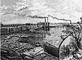 George Robinson Mill at Millview.jpg 905 × 660; 139 KB
-
 Jennifer Cook O'Toole (2014).jpeg 648 × 864; 192 KB
-
 Jennifer Cook O'Toole, Answering Audience Questions.jpeg 2 448 × 3 264; 2,03 MB
-
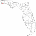
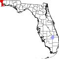 Map of Florida highlighting Escambia County.svg 1 130 × 1 126; 179 KB
-
 Memorial Day Weekend '08 - panoramio.jpg 3 008 × 2 000; 1,2 MB
-
 Model 7; East of Pensacola, Florida. Date- 12-06-1956 (21498488478).jpg 1 000 × 790; 199 KB
-
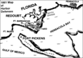 Nps pensacola bay sketch.PNG 458 × 321; 29 KB
-
 Project Blue Book report - 1967-10-7204416-Escambia County, Florida.pdf 4 154 × 3 304, 15 pagine; 2,71 MB
-
 Saw mill at Muscogee.jpg 600 × 448; 129 KB
-
 Seal of Escambia County, Florida.png 200 × 200; 60 KB
-
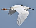 Snowy Egret (47544779051).jpg 2 085 × 1 609; 503 KB
-
 USA Escambia County, Florida age pyramid.svg 520 × 600; 8 KB


.jpeg)


.jpg)


.jpg)
