Category:Folkingham
Vai alla navigazione
Vai alla ricerca
village in South Kesteven, Lincolnshire, UK  | |||||
| Carica un file multimediale | |||||
| Istanza di | |||||
|---|---|---|---|---|---|
| Luogo | Folkingham, South Kesteven, Lincolnshire, Midlands Orientali, Inghilterra | ||||
 | |||||
English: Folkingham is a small village and civil parish situated eleven miles of north of Bourne on the northern edge of the District of South Kesteven in southern Lincolnshire, England. It has a population of 729.
Français : Folkingham est un petit village et paroisse civile situé au nord de Bourne sur l'extrémité nord de la District du Sud Kesteven dans le sud du Lincolnshire, Angleterre. Elle a une population de 729.
Sottocategorie
Questa categoria contiene le 4 sottocategorie indicate di seguito, su un totale di 4.
File nella categoria "Folkingham"
Questa categoria contiene 200 file, indicati di seguito, su un totale di 271.
(pagina precedente) (pagina successiva)-
 1 to 5 Market Place, Folkingham - geograph.org.uk - 5331437.jpg 5 184 × 3 456; 5,72 MB
-
 10 and 12 Chapel Square - geograph.org.uk - 965792.jpg 280 × 420; 65 KB
-
 13 Market Place, Folkingham - geograph.org.uk - 5331660.jpg 5 184 × 3 456; 7,45 MB
-
 16 - 10 Market Place, Folkingham - geograph.org.uk - 5332840.jpg 5 049 × 3 832; 6,45 MB
-
 16 to 10 The Market Place, Folkingham - geograph.org.uk - 5330813.jpg 5 184 × 3 456; 6,58 MB
-
 30 - 38 Market Place, Folkingham - geograph.org.uk - 5332900.jpg 4 873 × 3 249; 5,36 MB
-
 32 to 38 Market Place. - geograph.org.uk - 4871372.jpg 6 000 × 4 000; 6,51 MB
-
 36 Market Place, Folkingham, Lincolnshire, UK.jpg 6 578 × 4 385; 21,51 MB
-
 4 and 6 The Market Place, Folkingham - geograph.org.uk - 5330821.jpg 5 184 × 3 456; 7,58 MB
-
 7, 9, 9A and 11 Market Place, Folkingham - geograph.org.uk - 5331728.jpg 5 184 × 3 456; 5,58 MB
-
 A Cul-de-sac in Folkingham - geograph.org.uk - 5738797.jpg 6 032 × 4 014; 5,56 MB
-
 A hidden gem - geograph.org.uk - 5649807.jpg 6 032 × 4 014; 5,48 MB
-
 A main road - geograph.org.uk - 4865158.jpg 5 500 × 3 667; 7,86 MB
-
 A pleasant place to sit - geograph.org.uk - 5649790.jpg 6 032 × 4 014; 6,73 MB
-
 A wet village - geograph.org.uk - 6079758.jpg 6 032 × 4 014; 3,89 MB
-
 A15 south at Folkingham (geograph 2505160).jpg 640 × 480; 89 KB
-
 A15 through Folkingham - geograph.org.uk - 4116726.jpg 640 × 480; 309 KB
-
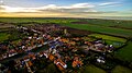 Aerial View Of Folkingham.jpg 3 992 × 2 242; 8,73 MB
-
 Amenity corner (geograph 6608473).jpg 6 252 × 4 164; 5,79 MB
-
 At the end of Churchfields - geograph.org.uk - 5887003.jpg 6 032 × 4 014; 4,28 MB
-
 Bend in road by Owens Barn Farm - geograph.org.uk - 2870934.jpg 1 280 × 853; 438 KB
-
 Big bales - geograph.org.uk - 5871295.jpg 12 000 × 3 623; 7,53 MB
-
 Billingborough Road - geograph.org.uk - 3848838.jpg 640 × 480; 61 KB
-
 Billingborough Road - geograph.org.uk - 4370680.jpg 4 000 × 3 000; 4,14 MB
-
 Birthorpe Ford - geograph.org.uk - 3369866.jpg 4 320 × 3 240; 5,84 MB
-
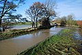 Birthorpe Ford in Flood - geograph.org.uk - 3238710.jpg 3 872 × 2 592; 2,42 MB
-
 Bourne Road (A15) (geograph 3699077).jpg 640 × 480; 55 KB
-
 Bourne Road (A15) - geograph.org.uk - 3699071.jpg 640 × 480; 53 KB
-
 Bourne Road, Folkingham - geograph.org.uk - 6197270.jpg 1 820 × 1 120; 1,12 MB
-
 Bungalows in Churchfields - geograph.org.uk - 5825951.jpg 6 032 × 4 014; 6,43 MB
-
 Bungalows in Churchfields - geograph.org.uk - 5887029.jpg 6 032 × 4 014; 5,64 MB
-
 Castle mounds, Folkingham - geograph.org.uk - 3763891.jpg 4 896 × 3 672; 6,76 MB
-
 Castle walls - geograph.org.uk - 3763841.jpg 4 896 × 3 672; 6,98 MB
-
 Changing rooms - geograph.org.uk - 6084053.jpg 6 032 × 4 014; 5,42 MB
-
 Chocolate House - geograph.org.uk - 4155833.jpg 4 896 × 3 672; 6,81 MB
-
 Church and Corner Shop, Folkingham - geograph.org.uk - 3936834.jpg 1 024 × 768; 212 KB
-
 Church Lane - geograph.org.uk - 6079755.jpg 4 014 × 6 032; 4,24 MB
-
 Church Lane, Folkingham - geograph.org.uk - 4291393.jpg 960 × 1 280; 511 KB
-
 Church View - geograph.org.uk - 1752911.jpg 1 944 × 2 592; 1,81 MB
-
 Churchfields Road - geograph.org.uk - 5838755.jpg 6 032 × 4 014; 4,66 MB
-
 Churchfields Road - geograph.org.uk - 5865952.jpg 6 032 × 4 014; 4,98 MB
-
 Crossroads - geograph.org.uk - 4734327.jpg 640 × 480; 73 KB
-
 Cul-de-sac - geograph.org.uk - 5887019.jpg 6 032 × 4 014; 4,4 MB
-
 Culverted spring - geograph.org.uk - 5649794.jpg 6 032 × 4 014; 5,7 MB
-
 Danish Place names.jpg 1 123 × 1 020; 608 KB
-
 Defibrillator at football club - geograph.org.uk - 6084070.jpg 5 973 × 3 841; 4,11 MB
-
 Depth marker at the Ford - geograph.org.uk - 5649797.jpg 6 032 × 4 014; 6,68 MB
-
 Detached houses in Walcot Lane - geograph.org.uk - 5865954.jpg 6 032 × 4 014; 5,75 MB
-
 Distant churches - geograph.org.uk - 4865144.jpg 6 000 × 4 000; 5,26 MB
-
 Drainage ditch seen from Billingborough Road - geograph.org.uk - 4371711.jpg 4 000 × 3 000; 4,26 MB
-
 Dyke and hedge - geograph.org.uk - 4865155.jpg 5 200 × 3 467; 7,89 MB
-
 Earth ramparts - geograph.org.uk - 3763716.jpg 4 896 × 3 672; 6,85 MB
-
 Earthworks in Field - geograph.org.uk - 3763728.jpg 4 896 × 3 672; 6,6 MB
-
 Entering Folkingham - geograph.org.uk - 2905990.jpg 1 280 × 853; 306 KB
-

-

-

-
 Farm track heading north - geograph.org.uk - 3848837.jpg 640 × 480; 66 KB
-
 Farmland east of Mareham Lane - geograph.org.uk - 3848821.jpg 640 × 480; 68 KB
-
 Farmland east of Mareham Lane - geograph.org.uk - 3848839.jpg 640 × 480; 71 KB
-
 Farmland on Beacon Hill - geograph.org.uk - 6330310.jpg 1 024 × 768; 154 KB
-
 Field and trees - geograph.org.uk - 5871388.jpg 14 243 × 3 000; 5,74 MB
-
 Field Drain - geograph.org.uk - 5855476.jpg 6 032 × 4 014; 3,1 MB
-
 Field near the New Bridge - geograph.org.uk - 3763368.jpg 4 896 × 3 672; 7,02 MB
-
 Field of rape and wind turbine - geograph.org.uk - 5358384.jpg 640 × 480; 280 KB
-
 Fields and woodland near the Warren - geograph.org.uk - 5358388.jpg 640 × 480; 306 KB
-
 Fields looking towards Folkingham - geograph.org.uk - 5146587.jpg 640 × 480; 74 KB
-
 Folkingham - geograph.org.uk - 4116739.jpg 640 × 480; 347 KB
-
 Folkingham - geograph.org.uk - 6079757.jpg 6 032 × 4 014; 4,86 MB
-
Folkingham 2020-09-18 1149.mp3 51 s; 1,63 MB
-
 Folkingham castle (geograph 3763852).jpg 4 896 × 3 672; 7,05 MB
-
 Folkingham Castle - geograph.org.uk - 3958559.jpg 1 024 × 776; 182 KB
-
 Folkingham Castle plan.jpg 819 × 553; 317 KB
-
 Folkingham church - geograph.org.uk - 2472694.jpg 640 × 480; 88 KB
-
 Folkingham Ford in Flood (geograph 3238737).jpg 3 872 × 2 592; 2,41 MB
-
 Folkingham from Greenfields Lane - geograph.org.uk - 628710.jpg 640 × 427; 97 KB
-
 Folkingham housing estate - geograph.org.uk - 5744394.jpg 6 032 × 4 014; 5,11 MB
-
 Folkingham Market Place - geograph.org.uk - 6261168.jpg 3 595 × 2 696; 1,09 MB
-
 Folkingham Store, Folkingham - geograph.org.uk - 2805367.jpg 800 × 600; 109 KB
-
 Folkingham Street View - geograph.org.uk - 1752794.jpg 2 592 × 1 944; 2,04 MB
-
 Folkingham Telephone Exchange (1) - geograph.org.uk - 4964423.jpg 2 592 × 1 944; 1,43 MB
-
 Folkingham Telephone Exchange (2) - geograph.org.uk - 4964433.jpg 2 592 × 1 944; 1,4 MB
-
 Folkingham village - geograph.org.uk - 4331344.jpg 1 024 × 768; 151 KB
-
 Folkingham Village Hall - geograph.org.uk - 4943731.jpg 640 × 481; 263 KB
-
 Folkingham Village.jpg 3 488 × 2 616; 3,69 MB
-
 Folkingham Water Tower - geograph.org.uk - 3699064.jpg 640 × 480; 32 KB
-
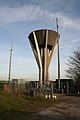 Folkingham Water Tower - geograph.org.uk - 90682.jpg 427 × 640; 58 KB
-
 Folkingham Water Tower.JPG 3 488 × 2 616; 2,78 MB
-
 Folkingham, Church Lane - geograph.org.uk - 1849236.jpg 640 × 474; 109 KB
-
 Folkingham, Market Place - geograph.org.uk - 1849139.jpg 640 × 480; 88 KB
-
 Folkingham, Market Place - geograph.org.uk - 1849270.jpg 640 × 490; 97 KB
-
 Folkingham, Market Place - geograph.org.uk - 1849301.jpg 640 × 480; 111 KB
-
 Folkingham, Market Place - geograph.org.uk - 4116731.jpg 640 × 480; 382 KB
-

-

-
 Folkingham, West Street - geograph.org.uk - 1849181.jpg 640 × 452; 73 KB
-
 Folkingham-Floods.JPG 3 488 × 2 616; 2,21 MB
-
 Football pitch and Allotments - geograph.org.uk - 6084061.jpg 6 032 × 4 014; 7,16 MB
-
 Footpath and Drain near Folkingham - geograph.org.uk - 6329882.jpg 1 024 × 768; 182 KB
-
 Footpath from Greenfields Lane - geograph.org.uk - 6214501.jpg 1 024 × 768; 233 KB
-
 Footpath off Billingborough Road - geograph.org.uk - 2757063.jpg 1 280 × 853; 367 KB
-

-
 Footpath to Folkingham - geograph.org.uk - 3848829.jpg 640 × 480; 54 KB
-
 Footpath to Laughton Lodge - geograph.org.uk - 3035692.jpg 640 × 427; 111 KB
-
 Footpath to Laughton Lodge - geograph.org.uk - 3035845.jpg 640 × 427; 115 KB
-
 Footpath to the shops - geograph.org.uk - 5738772.jpg 6 032 × 4 014; 5,27 MB
-
 Ford and footbridge - geograph.org.uk - 5148056.jpg 640 × 480; 113 KB
-
 Ford and Footbridge at Folkingham - geograph.org.uk - 1827479.jpg 3 872 × 2 592; 2,42 MB
-
 Ford on Spring Lane, Folkingham - geograph.org.uk - 4943201.jpg 640 × 480; 336 KB
-
 Former House of Correction, Folkingham - geograph.org.uk - 4763583.jpg 640 × 523; 162 KB
-
 Former village stocks - geograph.org.uk - 4871150.jpg 5 800 × 3 867; 7,94 MB
-
 Garden on South Street, Bourne - geograph.org.uk - 6194810.jpg 1 920 × 1 280; 1,22 MB
-
 Grade II gateway (geograph 6598590).jpg 4 163 × 6 251; 4,56 MB
-
 Green space in Churchfield Road - geograph.org.uk - 5890916.jpg 5 712 × 3 801; 7,78 MB
-
 Green space in churchfields - geograph.org.uk - 5775414.jpg 6 032 × 4 014; 5,91 MB
-
 Greenfields Lane - geograph.org.uk - 3035645.jpg 640 × 427; 116 KB
-
 Greenfields Lane - geograph.org.uk - 3035690.jpg 640 × 427; 118 KB
-
 Greenfields Lane - geograph.org.uk - 5148027.jpg 640 × 480; 65 KB
-
 Greenfields Lane - geograph.org.uk - 6214497.jpg 1 024 × 768; 245 KB
-
 Greenfields Lane - geograph.org.uk - 628536.jpg 640 × 427; 129 KB
-
 Greyhound Cottages, Folkingham - geograph.org.uk - 5332921.jpg 5 063 × 3 184; 6,17 MB
-

-
 Harvested fields - geograph.org.uk - 5871292.jpg 20 597 × 2 357; 7,75 MB
-
 Heading towards Folkingham - geograph.org.uk - 4331342.jpg 1 024 × 768; 97 KB
-
 Hedge and dyke - geograph.org.uk - 4865150.jpg 5 200 × 3 467; 7,8 MB
-
 House of correction - geograph.org.uk - 3763405.jpg 4 896 × 3 672; 6,65 MB
-
 House of Correction in Folkingham - geograph.org.uk - 6327344.jpg 1 024 × 768; 176 KB
-
 Houses at the end of Churchfield Road - geograph.org.uk - 5744387.jpg 6 032 × 4 014; 3,75 MB
-
 Houses in Churchfield - geograph.org.uk - 5886982.jpg 6 032 × 4 014; 4,73 MB
-
 Houses in Churchfields - geograph.org.uk - 5865947.jpg 6 032 × 4 014; 4,01 MB
-
 Houses in Folkingham - geograph.org.uk - 5737815.jpg 7 830 × 3 954; 6,37 MB
-
 Houses in West Street, Folkingham - geograph.org.uk - 5359400.jpg 640 × 480; 226 KB
-
 Houses on Sleaford Road, Folkingham - geograph.org.uk - 5657592.jpg 2 192 × 1 566; 865 KB
-
 Houses on Sleaford Road, Folkingham - geograph.org.uk - 6193329.jpg 1 840 × 1 146; 1,29 MB
-
 Houses on the hill (geograph 6599206).jpg 6 252 × 4 164; 4,08 MB
-
 It looks like a pub (geograph 6599193).jpg 6 252 × 4 164; 3,96 MB
-
 Junction with the A15 at Folkingham - geograph.org.uk - 1073609.jpg 640 × 460; 79 KB
-
 Kime Close - geograph.org.uk - 5887058.jpg 6 032 × 4 014; 6,08 MB
-
 Lane near Folkingham - geograph.org.uk - 5871287.jpg 7 371 × 6 461; 7,95 MB
-
 Laughton Manor Farm - geograph.org.uk - 277948.jpg 640 × 480; 79 KB
-
 Laughton water tower - geograph.org.uk - 6193125.jpg 1 920 × 1 280; 1,36 MB
-
 Looking towards Bourne on the A15 - geograph.org.uk - 312149.jpg 640 × 427; 74 KB
-
 Looking towards Folkingham - geograph.org.uk - 5148041.jpg 640 × 480; 78 KB
-
 Looking towards Owens Barn Farm - geograph.org.uk - 329638.jpg 640 × 427; 76 KB
-
 Looking towards water tower - geograph.org.uk - 5148008.jpg 640 × 480; 77 KB
-
 Low Farm - geograph.org.uk - 3035610.jpg 640 × 427; 112 KB
-
 Low Farm Touring and Camping Park - geograph.org.uk - 4943184.jpg 640 × 480; 335 KB
-
 Makeshift gate - geograph.org.uk - 4865162.jpg 5 500 × 3 667; 7,68 MB
-
 Mareham Lane heading north - geograph.org.uk - 3848823.jpg 640 × 480; 51 KB
-
 Mareham Lane heading north - geograph.org.uk - 3848840.jpg 480 × 640; 87 KB
-
 Mareham Lane, Threekingham - geograph.org.uk - 5222631.jpg 640 × 427; 54 KB
-
 Mareham Road entering South Kesteven - geograph.org.uk - 2757071.jpg 1 280 × 853; 1 010 KB
-
 Market Place, Folkingham, east side - geograph.org.uk - 4291392.jpg 1 280 × 864; 532 KB
-
 Market Place, Folkingham, west side (geograph 6709550).jpg 1 024 × 768; 176 KB
-
 Millennium Orchard, Folkingham - geograph.org.uk - 4943704.jpg 640 × 480; 324 KB
-
 Minor earthworks - geograph.org.uk - 3763642.jpg 4 896 × 3 672; 7,3 MB
-
 Modern housing - geograph.org.uk - 5831143.jpg 6 032 × 4 014; 4,35 MB
-
 Newly Cleared - geograph.org.uk - 3763693.jpg 4 896 × 3 672; 6,84 MB
-
 Not Dry ford at Birthorpe - geograph.org.uk - 3369869.jpg 4 320 × 3 240; 5,54 MB
-
 Not yet a ford - geograph.org.uk - 6223293.jpg 1 024 × 768; 252 KB
-

-
 Open space in Churchfields road - geograph.org.uk - 5738801.jpg 6 032 × 4 014; 7,26 MB
-
 Ordnance Survey Flush Bracket S5223 - geograph.org.uk - 4111470.jpg 4 000 × 3 000; 4,16 MB
-
 Out for a ride - geograph.org.uk - 5872532.jpg 6 032 × 4 014; 5,55 MB
-
 Overgrown stream - geograph.org.uk - 3763659.jpg 4 896 × 3 672; 7,03 MB
-
 Overgrown stream - geograph.org.uk - 3763672.jpg 4 896 × 3 672; 6,74 MB
-
 Panorama of Folkingham - geograph.org.uk - 4861557.jpg 10 173 × 1 500; 7,74 MB
-
 Path along the ramparts - geograph.org.uk - 3763381.jpg 4 896 × 3 672; 7,11 MB
-
 PeloricFoxglove.jpg 490 × 653; 160 KB
-
 Playing field - geograph.org.uk - 6084049.jpg 6 032 × 4 014; 5,41 MB
-
 Public Footpath - geograph.org.uk - 4865167.jpg 6 000 × 4 000; 5,47 MB
-
 Public footpath - geograph.org.uk - 5146612.jpg 640 × 480; 67 KB
-
 Public footpath - geograph.org.uk - 5148020.jpg 640 × 480; 84 KB
-
 Public Footpath off Mareham Lane - geograph.org.uk - 2906107.jpg 682 × 1 024; 336 KB
-
 Quaintways, 17 Market Place, Folkingham - geograph.org.uk - 5331804.jpg 3 327 × 4 989; 6,73 MB
-
 Roadside stream - geograph.org.uk - 5650746.jpg 6 032 × 4 014; 7,3 MB
-
 Semi-detached houses - geograph.org.uk - 5887104.jpg 6 032 × 4 014; 4,91 MB
-
 Semi-detached in Churchfields - geograph.org.uk - 5865950.jpg 6 032 × 4 014; 6,25 MB
-
 Shared access - geograph.org.uk - 5773157.jpg 6 032 × 4 014; 4,66 MB
-
 Shared access - geograph.org.uk - 5886978.jpg 6 032 × 4 014; 5,31 MB
-
 Sign, Folkingham - geograph.org.uk - 4763530.jpg 520 × 640; 282 KB
-
 Slate headstones, Folkingham churchyard - geograph.org.uk - 6214489.jpg 1 024 × 768; 273 KB
-
 Sleaford Road, Folkingham - geograph.org.uk - 5653751.jpg 1 980 × 1 452; 965 KB
-
 Smallholder farm shop on the right - geograph.org.uk - 4331343.jpg 1 024 × 768; 175 KB
-
 Spring Farmhouse, Folkingham (geograph 6709564).jpg 1 024 × 768; 150 KB
-
 Spring Lane ford - geograph.org.uk - 3035618.jpg 640 × 427; 139 KB
-
 Square bales - geograph.org.uk - 3155947.jpg 4 320 × 3 240; 5,34 MB
-
 St Andrew's Folkingham - geograph.org.uk - 2805373.jpg 800 × 600; 130 KB
-
 Straw stack - geograph.org.uk - 3763378.jpg 4 896 × 3 672; 6,59 MB
-
 Stream at the Ford - geograph.org.uk - 5650749.jpg 6 032 × 4 014; 4,72 MB
-
 Tea Room - geograph.org.uk - 4872400.jpg 6 480 × 4 320; 7,6 MB
-
 Tea shop - geograph.org.uk - 4155821.jpg 4 896 × 3 672; 6,53 MB
-
 Tea Shop and Houses, Folkingham - geograph.org.uk - 3936940.jpg 800 × 614; 97 KB
-
 The A15 - geograph.org.uk - 6062697.jpg 6 032 × 4 014; 6,33 MB
-
 The Barn, Spring Lane, Folkingham - geograph.org.uk - 4943195.jpg 640 × 480; 279 KB
-
 The centre of Folkingham - geograph.org.uk - 4371727.jpg 4 000 × 3 000; 4,14 MB
-
 The centre of Folkingham - geograph.org.uk - 5653750.jpg 1 937 × 1 446; 860 KB
-
 The edge of the village - geograph.org.uk - 5738820.jpg 6 032 × 4 014; 7,31 MB
-
 The end of the road - geograph.org.uk - 5738818.jpg 5 835 × 3 122; 5,34 MB
-
 The Ford - geograph.org.uk - 5649796.jpg 6 032 × 4 014; 6,61 MB


.jpg)

.jpg)


_(geograph_3699077).jpg)
_-_geograph.org.uk_-_3699071.jpg)


.jpg)


.jpg)


_-_geograph.org.uk_-_4964423.jpg)
_-_geograph.org.uk_-_4964433.jpg)


.jpg)


.jpg)
.jpg)


.jpg)


.jpg)


