Category:Forez
Naar navigatie springen
Naar zoeken springen
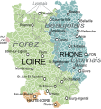
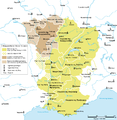
former province of France | |||||
| Media uploaden | |||||
| Is een |
| ||||
|---|---|---|---|---|---|
| Locatie |
| ||||
 | |||||
Ondercategorieën
Deze categorie bevat de volgende 39 subcategorieën, van de 39 in totaal.
A
B
- Col du Béal (18 B)
- Brique du Forez (1 B)
C
- Canal du Forez (7 B)
- Col de la Loge (4 B)
- Col Saint-Thomas (7 B)
F
- Fossat (2 B)
- Fourme de Montbrison (29 B)
H
- Haute-vallée des Supeyres (9 B)
J
L
M
P
- Prabouré (9 B)
S
U
V
Media in categorie "Forez"
Deze categorie bevat de volgende 68 bestanden, van in totaal 68.
-
 Armoiries Forez.svg 600 × 660; 6 kB
-
 Capture d’écran 2022-07-07 à 12.28.23.png 181 × 118; 9 kB
-
 Boën (42).jpg 3.648 × 2.736; 4,17 MB
-
 Canal Forez & prieuré Saint-Romain Puy (42).jpg 3.648 × 2.736; 4,16 MB
-
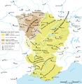
 Carte du Lyonnais.svg 1.609 × 1.725; 532 kB
-
 Carte-Royaume-dArles.png 1.500 × 1.529; 412 kB
-
 Chalmazel (42).jpg 3.648 × 2.736; 4,25 MB
-
 Champdieu depuis la Madone.jpg 4.032 × 3.024; 4,73 MB
-
 Charles Joseph Beauverie Ebene von Forez.jpg 1.200 × 674; 524 kB
-
 D69 - Montbrison (42).JPG 3.648 × 2.736; 4,06 MB
-
 Daniel Pouget.jpg 695 × 797; 291 kB
-
 Depuis château Couzan.jpg 2.736 × 3.648; 6,46 MB
-
 Eglise Saint-Romain Puy (42).jpg 3.648 × 2.736; 4,23 MB
-
 F-BJJX Jodel D 127.jpg 1.698 × 1.124; 269 kB
-
 Forez Plaine Panorama.jpg 10.797 × 2.759; 11,21 MB
-
 Forêt enneigée (Parc naturel régional du Livradois-Forez).JPG 2.048 × 1.536; 1,65 MB
-
 France & Colonies-1894-Plaine du Forez.jpg 4.565 × 6.369; 4,26 MB
-
 Hautes-Chaumes (Livradois-Forez).jpg 2.056 × 1.535; 1,03 MB
-
 Jeanne de Montfort, comtesse de Forez.png 343 × 557; 78 kB
-
 Karte Königreich Arelat DE.png 1.500 × 1.529; 414 kB
-
 La Chambonie.JPG 2.592 × 1.944; 2,09 MB
-
 Le monde merveilleux des drosera rotundifolia.jpg 3.028 × 2.022; 449 kB
-
 Les Français peints par eux mêmes-Le Forésien.jpg 473 × 709; 68 kB
-
 Les Hautes-Chaumes (Livradois-Forez).jpg 2.048 × 1.536; 1,17 MB
-
 Lignon Forez.jpg 2.736 × 3.648; 7,5 MB
-
 "Lionnois, Forest, Beaviolois et Masconois" (21634336003).jpg 4.158 × 3.084; 2,68 MB
-
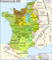
 Map France 1030-br.svg 989 × 1.126; 741 kB
-
 Map France 1030-de.svg 988 × 1.124; 1,49 MB
-
 Map France 1030-es.svg 1.053 × 1.199; 4,12 MB
-
 Map France 1030-fr.svg 989 × 1.126; 718 kB
-
 Map France 1030-ru.svg 988 × 1.124; 789 kB
-
 Map France 1030-uk.svg 988 × 1.124; 789 kB
-
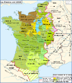
 Map Kingdom Arelat AR.png 1.454 × 1.485; 856 kB
-
 Map Kingdom Arelat EN.png 1.310 × 1.338; 209 kB
-
 Map Kingdom Arelat-el.png 1.310 × 1.338; 227 kB
-
 Margerie Plaine Pneus.jpg 5.372 × 3.442; 6,12 MB
-
 Marols Paturages Plaine.jpg 5.430 × 3.454; 6,72 MB
-
 Marols Plaine Pilat.jpg 5.323 × 3.549; 7,79 MB
-
 Marols Plaine.jpg 5.417 × 3.611; 7,9 MB
-
 Marols Pre.jpg 5.442 × 3.487; 8,76 MB
-
 Marols Toit Plaine Lumier.jpg 5.445 × 3.630; 5,71 MB
-
 Marols Vue Plaine.jpg 5.225 × 2.127; 6,18 MB
-
 Panoramaforez.jpg 6.870 × 1.812; 3,11 MB
-
 Parc naturel régional du Livradois-Forez.jpg 2.048 × 1.536; 955 kB
-
 Parc naturel régional duLivradois-Forez.jpg 2.048 × 1.536; 1,73 MB
-
 Paysage Barrage Couzon.jpg 2.592 × 1.944; 2,33 MB
-
 Place neuve quartier Saint Jacques.jpg 709 × 496; 104 kB
-
 Plaine du Forez depuis le Pic de Montsupt.jpg 4.032 × 3.024; 3,31 MB
-
 Plaine du Forez vue depuis Marcilly-le-Chatel.png 3.253 × 1.636; 6,62 MB
-
 Plaine du Forez, vue de Rozier-en-Donzy.jpg 1.600 × 902; 882 kB
-
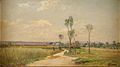
 Plaine du Forez.jpg 1.024 × 768; 114 kB
-
 Plaine et Mts du Forez.jpg 1.024 × 768; 480 kB
-
 Preuves de 1708.jpg 3.264 × 4.928; 9,22 MB
-
 Preuves de noblesse de 1668 devant Jean Dubat du Parlement Royal de Bordeaux.jpg 3.264 × 4.928; 3,36 MB
-
 Régiment de Forez 1789 Ensign.png 150 × 469; 119 kB
-
 Saint-Romain Puy (42) nord & plaine Forez.jpg 3.648 × 2.736; 3,5 MB
-
 Saint-Romain Puy (42).jpg 3.648 × 2.736; 4,22 MB
-
 Table orientation Chazelles-sur-Lavieu.jpg 4.032 × 3.024; 4,01 MB
-
 Val Lignon nord.jpg 3.648 × 2.736; 3,59 MB
-
 Verallia Saint-Romain Puy (42).jpg 3.648 × 2.736; 4,28 MB
-
 Vestiges prieuré Saint-Romain Puy (42).jpg 3.648 × 2.736; 4,32 MB
-
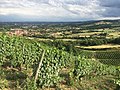
 Vignoble du Côtes-du-forez.jpg 2.304 × 1.728; 1,6 MB
-
 Vollore-Montagne - Pierre Pamole 20210811-01.jpg 5.472 × 3.648; 7,87 MB
-
 Vollore-Montagne - Pierre Pamole 20210811-02.jpg 5.472 × 3.648; 7,2 MB
-
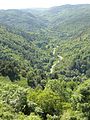
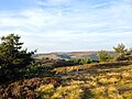
 Vue Monts du Forez depuis Crêt de la Perdrix.jpg 2.560 × 1.920; 2,77 MB
-
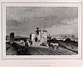 Vue prise du chemin de fer de St Etienne à Andrézieux. St Rambert.jpg 1.217 × 980; 907 kB
-
 Vue prise du chemin de fer de St Etienne à Andrézieux.jpg 1.054 × 707; 669 kB
-
 Vue sur les volcans de la Haute-Loire (Parc naturel régional du Livradois-Forez).jpg 2.048 × 1.536; 1,02 MB


.jpg)
.jpg)


.jpg)


.JPG)


.jpg)

.JPG)

.jpg)


.jpg)

.jpg)


_nord_%26_plaine_Forez.jpg)
.jpg)


.jpg)
.jpg)


.jpg)