Category:Fort Good Hope (Ghana)
Zur Navigation springen
Zur Suche springen
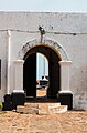
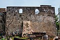
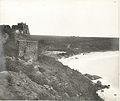
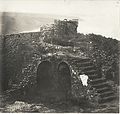
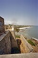
English: The Fort De Goede Hoop (English: "Fort Good Hope") was built in 1664 at the village Senya-Beraku (hist. Berrecoe, Senniah-Beracoe, Bercoe or similarly) by the Dutch.
| Objektposition | | Karte mit allen Koordinaten: OpenStreetMap |
|---|
Burg in Ghana  | |||||
| Medium hochladen | |||||
| Ist ein(e) | |||||
|---|---|---|---|---|---|
| Ist Teil von | |||||
| Ort | Senya Beraku, Awutu Senya District, Central Region, Ghana | ||||
| Schutzkategorie |
| ||||
| Datum der Gründung, Erstellung, Entstehung, Erbauung |
| ||||
 | |||||
Notice:
Historically was differentiated between "Little-Beraku" (= contemporary Senya Beraku = location of the fort) on the western border of the Densu (river) swamps and "Great-Beraku" on the eastern border. Senya Beraku was in historical times an important whistle stop on the old trading route between Accra and Winneba.
Medien in der Kategorie „Fort Good Hope (Ghana)“
Folgende 19 Dateien sind in dieser Kategorie, von 19 insgesamt.
-
 AMH-7733-NA Floor plan of Fort Goede Hoop at Berku.jpg 1.572 × 2.400; 643 KB
-
 Fort de Goede Hoop, entrance.jpg 4.000 × 3.000; 3,72 MB
-
 Fort de Goede Hoop, front and side.jpg 4.000 × 3.000; 4,11 MB
-
 Fort Goede Hoop (Ghana).png 457 × 367; 150 KB
-
Fort Goede Hoop, Ghana.webm 8,3 s, 5.120 × 2.880; 24,95 MB
-
 Fort Good Hope 1.2.jpg 3.129 × 4.754; 3,48 MB
-
 Fort Good Hope 1.3.jpg 5.023 × 3.349; 5,56 MB
-
 Fort Good Hope 1.jpg 5.472 × 3.648; 6,28 MB
-
 Fort Good Hope in Ghana.jpg 6.000 × 4.000; 4,85 MB
-
 Overzicht binnenplaats naar de achtergevel - Senya Beraku - 20375244 - RCE.jpg 3.375 × 2.204; 3,21 MB
-

-
 Overzicht binnenplaats naar de voorgevel - Senya Beraku - 20375248 - RCE.jpg 1.200 × 783; 174 KB
-

-
 Overzicht voorgevel - Senya Beraku - 20375250 - RCE.jpg 1.200 × 783; 211 KB
-
 The National Archives UK - CO 1069-34-41-1-001.jpg 854 × 718; 156 KB
-
 The National Archives UK - CO 1069-34-57 001.jpg 841 × 743; 115 KB
-
 The National Archives UK - CO 1069-34-59-1-001.jpg 840 × 705; 201 KB
-
 The National Archives UK - CO 1069-34-59-2-002.jpg 751 × 711; 231 KB
-


.png)


