Category:Freiland bei Deutschlandsberg
Vai alla navigazione
Vai alla ricerca
comune austriaco   | |||||
| Carica un file multimediale | |||||
| Istanza di |
| ||||
|---|---|---|---|---|---|
| Luogo | |||||
| Superficie |
| ||||
| Altezza sul mare |
| ||||
 | |||||
Sottocategorie
Questa categoria contiene le 7 sottocategorie indicate di seguito, su un totale di 7.
File nella categoria "Freiland bei Deutschlandsberg"
Questa categoria contiene 23 file, indicati di seguito, su un totale di 23.
-
 AUT Freiland bei Deutschlandsberg COA.svg 416 × 496; 5 KB
-
 Wappen Freiland.jpg 166 × 208; 25 KB
-
 Admontischer Burgfried Freiland.jpg 515 × 446; 222 KB
-
 Fahrplan-St-Oswald.jpg 5 021 × 1 681; 1,59 MB
-
 Fahrpläne Deutschlandsberg Glashütten St Oswald Bruck Seewiesen Sommer 1956.jpg 5 376 × 4 339; 9,37 MB
-
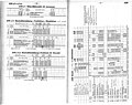 Fahrpläne Deutschlandsberg Glashütten St Oswald Bruck Thörl 1956-57.jpg 5 544 × 4 374; 5,75 MB
-
 Fahrpläne Deutschlandsberg Glashütten St Oswald Thörl Buchberg 1961-62.jpg 4 228 × 5 296; 13,07 MB
-
 Fahrpläne Deutschlandsberg Schwanberg Wies 1975-76.jpg 10 573 × 8 327; 12,51 MB
-
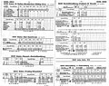 Fahrpläne Stainz Deutschlandsberg 1969-70.jpg 5 311 × 4 203; 12,12 MB
-
 Fahrschein Kortschak Deutschlandsberg Glashütten St Oswald 1953.jpg 3 439 × 2 081; 4,8 MB
-
 Freiland bei Deutschlandsberg im Bezirk DL.png 645 × 645; 29 KB
-
 Freiland bei Deutschlandsberg vor den Rosenkogelhängen.jpg 2 896 × 1 944; 3,39 MB
-
 Freiland Rosenkogel von Kruckenberg aus.jpg 2 896 × 1 944; 3,54 MB
-
 GKB Linie 764.jpg 9 790 × 4 591; 7,49 MB
-
 Hebalmstraße bei Freiland.jpg 1 944 × 2 896; 1,38 MB
-
 Hebalmstraße Schwarzkogel.jpg 2 896 × 1 944; 3,57 MB
-
 Hebalmstraße Stoffkogel Schwarzkogel Wildbachtal.jpg 2 896 × 1 944; 3,5 MB
-
 Jakobistatue Freiland.jpg 1 712 × 2 288; 2,87 MB
-
 Map at freiland bei deutschlandsberg.png 400 × 240; 3 KB
-
 Post Begleitadresse Bartljürgl.jpg 6 708 × 4 968; 31,7 MB
-
 Postanweisungsabschnitt Absender ca 1900.jpg 2 193 × 5 931; 21,34 MB
-
 RAD-Lager Wolfsriegel.jpg 3 097 × 1 945; 3,75 MB
-
 Wildbachtal breit.jpg 2 896 × 1 944; 4,51 MB


