Category:Geology of Israel
Zur Navigation springen
Zur Suche springen
| Medium hochladen | |||||
| Ist ein(e) |
| ||||
|---|---|---|---|---|---|
| Zentrales Thema | |||||
| |||||
Unterkategorien
Es werden 45 von insgesamt 45 Unterkategorien in dieser Kategorie angezeigt:
In Klammern die Anzahl der enthaltenen Kategorien (K), Seiten (S), Dateien (D)
*
+
- Geological maps of Israel (8 D)
B
- Bulbus rocks in the Negev (4 D)
E
F
- Faults in Israel (1 D)
- Folds in Israel (5 D)
G
- Geological Survey of Israel (2 D)
H
I
K
- Kedumim - Geology (1 D)
M
- Messinian salinity crisis (27 D)
O
Q
S
T
V
- Volcanoes in Israel (24 D)
W
Y
- Yiftach Fissures (4 D)
Medien in der Kategorie „Geology of Israel“
Folgende 130 Dateien sind in dieser Kategorie, von 130 insgesamt.
-
 103239 karst pit near sasa-filled with partial rainwater- PikiWiki Israel.jpg 4.032 × 3.024; 5,34 MB
-
 103240 karst pit near sasa-filled with partial rainwater- PikiWiki Israel.jpg 4.032 × 3.024; 7,67 MB
-
 103241 karst pit near sasa-filled with partial rainwater- PikiWiki Israel.jpg 4.032 × 3.024; 3,5 MB
-
 103242 karst pit near sasa-filled with partial rainwater- PikiWiki Israel.jpg 4.032 × 3.024; 5,46 MB
-
 103353 merat phar - on the north road between mount adir PikiWiki Israel.jpg 4.032 × 3.024; 4,79 MB
-
 103354 merat phar - on the north road between mount adir PikiWiki Israel.jpg 4.032 × 3.024; 3,8 MB
-
 103355 merat phar - on the north road between mount adir PikiWiki Israel.jpg 4.032 × 3.024; 7,77 MB
-
 103460 the quarry at the gaaton junction in the west of t PikiWiki Israel.jpg 3.264 × 2.448; 2,85 MB
-
 103461 the quarry at the gaaton junction in the west of t PikiWiki Israel.jpg 3.264 × 2.448; 4,44 MB
-
 103462 the quarry at the gaaton junction in the west of t PikiWiki Israel.jpg 3.264 × 2.448; 3,22 MB
-
 103463 the quarry at the gaaton junction in the west of t PikiWiki Israel.jpg 3.264 × 2.448; 2,45 MB
-
 106897 abandoned quarry on the shaver-paki'in lin PikiWiki Israel.jpg 4.032 × 3.024; 4,04 MB
-
 110792 amazeho park PikiWiki Israel.jpg 4.624 × 3.468; 5,76 MB
-
 110793 amazeho park PikiWiki Israel.jpg 3.468 × 4.624; 6,8 MB
-
 110794 amazeho park PikiWiki Israel.jpg 4.000 × 3.000; 3,78 MB
-
 AmmoniteWallTamar052811.jpg 3.185 × 2.580; 5,87 MB
-
 Arabian-Nubian shield He.jpg 1.600 × 1.200; 236 KB
-

-
 Bulbuses on Har Karkom.jpg 5.312 × 2.988; 4,41 MB
-
 Chert lens in the Chalk a road 38.jpg 811 × 597; 89 KB
-
 Cross Bedding Makhtesh Ramon.JPG 2.048 × 1.536; 1,3 MB
-
 Dead Sea Coastal Erosion March 2012.JPG 4.000 × 3.000; 3,85 MB
-
 Dead Sea Transform map and cross section.jpg 748 × 649; 75 KB
-
 Electric Turbines And The Hermon.JPG 2.560 × 1.920; 2,25 MB
-
 ETH-BIB-Palästina, geolog. Profil und Blankenhorn-Dia 247-Z-00191.tif 3.618 × 2.985; 31,01 MB
-
 Flint-Concretions--section2.jpg 390 × 246; 33 KB
-
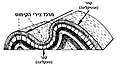 Fold He.jpg 609 × 328; 63 KB
-
 Geo (2).jpg 1.317 × 1.515; 352 KB
-
 Ghareb Oil Shale.jpg 2.972 × 1.180; 2,53 MB
-
 Gnathichnus Cenomanian 020413.JPG 1.560 × 808; 1,19 MB
-
 Great Rift Dead Sea Opening he.svg 200 × 470; 26 KB
-
 Ha-Minsara (The Carpentry Shop) in Makhtesh Ramon, Negev, Israel.jpg 798 × 1.064; 459 KB
-
 Hatrurim Location Hebrew.jpg 652 × 367; 39 KB
-
 Hazeva cobbles.jpg 3.000 × 2.000; 5,94 MB
-
 HiatusConcretionsIsrael060910.jpg 4.000 × 2.322; 7,57 MB
-
 HoneycombWeatheringCambrianIsrael.jpg 4.000 × 3.000; 8,62 MB
-
 Hyrcania Valley IMG 1912.JPG 3.648 × 2.736; 4,75 MB
-
 Jurassic stones from Burj el Maleh Israel.jpg 2.103 × 1.633; 2,07 MB
-
 Layers lissan formation.jpg 655 × 628; 156 KB
-
 MatmorFormation2009.JPG 4.000 × 3.000; 5,09 MB
-
 Mazokeatekim.JPG 384 × 512; 57 KB
-
 Mazokeatekima.JPG 640 × 480; 57 KB
-
 Middle Menuha Formation Wadi Zihor.JPG 3.872 × 2.592; 7,03 MB
-
 Mount Sodom Halite Layers 071213.jpg 2.600 × 1.744; 3,12 MB
-
 Mountseirsinaiwe00hull Page 228.png 2.806 × 1.216; 1,44 MB
-
 Mountseirsinaiwe00hull Page 272.png 2.561 × 1.051; 255 KB
-
 MountSodom061607.jpg 3.228 × 2.116; 4,65 MB
-
 Naari a MAON.jpg 2.592 × 1.944; 1,72 MB
-
 Naari a Nechusha.jpg 731 × 574; 68 KB
-
 Nappe, 'Devil's Hand', Israel (detail).JPG 3.872 × 2.592; 2,49 MB
-
 Nappe, 'Finger of God', Israel.jpg 1.024 × 678; 386 KB
-
 Northern Golan Height's mountains.JPG 3.648 × 2.736; 500 KB
-
 Oil shale in Israel.png 593 × 962; 107 KB
-
 Ora hardground MR.jpg 4.911 × 3.253; 6,63 MB
-
 PikiWiki Israel 29100 Geology of Israel.JPG 3.872 × 2.592; 3,78 MB
-
 PikiWiki Israel 30073 Geography of Israel.JPG 3.216 × 4.288; 5,38 MB
-
 PikiWiki Israel 36728 Mount Avital Golan Heights.jpg 4.128 × 2.322; 5,5 MB
-
 PikiWiki Israel 37972 Nature and Colors.JPG 3.264 × 1.840; 2,63 MB
-
 PikiWiki Israel 38061 Nature and Colors.JPG 3.872 × 2.592; 2,1 MB
-
 PikiWiki Israel 40453 Geology of Israel.jpg 2.448 × 3.264; 3,47 MB
-
 PikiWiki Israel 41473 Geology of Israel.jpg 1.692 × 1.128; 748 KB
-
 PikiWiki Israel 4429 dyke in machtesh ramon negev.JPG 2.048 × 1.536; 550 KB
-
 PikiWiki Israel 4430 dyke in machtesh ramon negev.JPG 2.048 × 1.536; 630 KB
-
 PikiWiki Israel 46170 Geology of Israel.JPG 2.592 × 1.944; 1,28 MB
-
 PikiWiki Israel 48450 Geography of Israel.jpg 3.264 × 1.836; 1,16 MB
-
 PikiWiki Israel 48452 Geography of Israel.jpg 3.264 × 1.836; 1.018 KB
-
 PikiWiki Israel 48485 Geography of Israel.JPG 1.179 × 786; 192 KB
-
 PikiWiki Israel 48487 Geography of Israel.JPG 1.179 × 786; 240 KB
-
 PikiWiki Israel 48488 Geography of Israel.JPG 1.179 × 786; 298 KB
-
 PikiWiki Israel 48491 Geography of Israel.JPG 1.179 × 786; 283 KB
-
 PikiWiki Israel 48705 Geology of Israel.JPG 5.184 × 3.456; 914 KB
-
 PikiWiki Israel 48706 Geology of Israel.JPG 5.184 × 3.456; 741 KB
-
 PikiWiki Israel 48795 Geography of Israel.JPG 1.179 × 786; 307 KB
-
 PikiWiki Israel 49949 park timna.jpg 2.368 × 3.512; 2,78 MB
-
 PikiWiki Israel 50493 dead sea.jpg 3.456 × 2.304; 1,83 MB
-
 PikiWiki Israel 50499 carmel mountain.jpg 3.456 × 2.304; 1,36 MB
-
 PikiWiki Israel 50512 timna.jpg 2.560 × 1.920; 894 KB
-
 PikiWiki Israel 50513 timna.jpg 2.560 × 720; 443 KB
-
 PikiWiki Israel 50514 timna.jpg 3.456 × 2.304; 1,3 MB
-
 PikiWiki Israel 50515 timna.jpg 3.456 × 2.304; 1,45 MB
-
 PikiWiki Israel 50516 timna.jpg 3.456 × 2.304; 1,25 MB
-
 PikiWiki Israel 50517 timna.jpg 3.456 × 2.304; 1,25 MB
-
 PikiWiki Israel 50533 barak canyon, israel.jpg 3.456 × 2.304; 2,35 MB
-
 PikiWiki Israel 50534 barak canyon, israel.jpg 3.456 × 2.304; 1,66 MB
-
 PikiWiki Israel 50535 barak canyon, israel.jpg 3.456 × 2.304; 1,76 MB
-
 PikiWiki Israel 50555 casuy dune, israel.jpg 4.990 × 3.327; 2,99 MB
-
 PikiWiki Israel 5980 Great Rift Valley.jpg 2.198 × 3.295; 697 KB
-
 PikiWiki Israel 6088 Ramon Canyon.jpg 2.048 × 1.536; 416 KB
-
 PikiWiki Israel 75023 iris hill.jpg 2.204 × 1.330; 2,1 MB
-
 PikiWiki Israel 75024 iris hill.jpg 2.374 × 1.920; 2,28 MB
-
 PikiWiki Israel 75025 iris hill.jpg 2.353 × 1.753; 1,2 MB
-
 PikiWiki Israel 75137 sinkholes at eingedi.jpg 6.240 × 4.160; 4,8 MB
-
 PikiWiki Israel 75138 sinkholes at eingedi.jpg 5.976 × 3.984; 4,01 MB
-
 PikiWiki Israel 75420 iris hill.jpg 5.120 × 3.840; 4,69 MB
-
 PikiWiki Israel 75421 iris hill.jpg 5.120 × 3.288; 5,31 MB
-
 PikiWiki Israel 75422 iris hill.jpg 3.648 × 2.736; 4,34 MB
-
 PikiWiki Israel 75423 iris hill.jpg 3.648 × 2.736; 2,32 MB
-
 PikiWiki Israel 75424 iris hill.jpg 1.300 × 886; 470 KB
-
 PikiWiki Israel 75425 iris hill.jpg 3.000 × 2.250; 3,03 MB
-
 PikiWiki Israel 75584 the ancient man.jpg 2.048 × 1.536; 627 KB
-
 PikiWiki Israel 75673 red canyon.jpg 5.184 × 3.456; 2,73 MB
-
 PikiWiki Israel 75674 red canyon.jpg 5.184 × 3.456; 2,84 MB
-
 PikiWiki Israel 78536 a conglomerate in the river of david.jpg 1.199 × 1.422; 741 KB
-
 PikiWiki Israel 78938 timna valley.jpg 3.600 × 2.400; 2,11 MB
-
 PikiWiki Israel 8025 Ein Yorqeam.jpg 768 × 1.024; 357 KB
-
 PikiWiki Israel 8026 Ein Yorqeam.jpg 1.024 × 560; 263 KB
-
 PikiWiki Israel 8027 Ein Yorqeam.jpg 719 × 1.024; 471 KB
-
 PikiWiki Israel 8105 mine cars from timna mines.jpg 2.048 × 1.536; 673 KB
-
 PikiWiki Israel 83285 tivertino.jpg 2.896 × 1.944; 2 MB
-
 Red Limestone.png 2.654 × 2.206; 15,07 MB
-
 Red-Canyon-200910-5000.jpg 2.592 × 1.790; 350 KB
-

-
 Sedimentary rock near Amram Columns.jpg 2.832 × 2.128; 1,77 MB
-
 Shen Ramon Stock.JPG 1.024 × 685; 230 KB
-
 SmallCrater03 ST 08.JPG 2.724 × 910; 1,82 MB
-
 SmallCrater04 ST 08.JPG 3.516 × 910; 2,26 MB
-
 SmallCrater05 ST 08.JPG 2.048 × 1.536; 1.001 KB
-
 SmallCrater06 ST 08.JPG 2.048 × 1.536; 940 KB
-
 Sodom Salt Cave 031712.JPG 4.000 × 2.370; 5,85 MB
-
 Soft Sediment Deformation Dead Sea.JPG 3.179 × 1.992; 5,53 MB
-
 Soreq formation2.jpg 800 × 581; 79 KB
-
 Strata Colors in Makhtesh Ramon.jpg 3.264 × 2.448; 5,3 MB
-
 Sweet water in the Well at salt sea a Dor beach Israel.jpg 2.532 × 1.657; 938 KB
-
 Syrian arc 2.jpg 419 × 349; 36 KB
-
 The hill of Burj el Maleh.jpg 2.092 × 1.463; 1,45 MB
-
 View from the top of Ha-Minsara (The Carpentry Shop), Makhtesh Ramon, Israel.jpg 1.064 × 798; 521 KB
-
 Ydaat the cave.JPG 2.592 × 1.944; 1,38 MB
-
 אצבע אלוהים נחל עתק.jpg 4.000 × 3.000; 7,07 MB
-
 אשת לוט.JPG 3.264 × 2.448; 1,68 MB
-
 נחל עתק.jpg 4.000 × 3.000; 8,15 MB


.jpg)


_in_Makhtesh_Ramon,_Negev,_Israel.jpg)


.JPG)


,_Israel.jpg)


,_Makhtesh_Ramon,_Israel.jpg)


