Category:Geology of the United Kingdom
Vai alla navigazione
Vai alla ricerca
regional geology | |||||
| Carica un file multimediale | |||||
| Sottoclasse di | |||||
|---|---|---|---|---|---|
| Luogo |
| ||||
| |||||
Sottocategorie
Questa categoria contiene le 70 sottocategorie indicate di seguito, su un totale di 70.
*
+
B
C
E
F
G
I
K
M
N
O
P
S
T
U
V
W
File nella categoria "Geology of the United Kingdom"
Questa categoria contiene 61 file, indicati di seguito, su un totale di 61.
-
 XII.—Notes on Cambridge geology (IA biostor-90790).pdf 681 × 1 166, 14 pagine; 5,42 MB
-
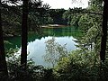
 Blue Pool, Furzebrook, Dorset - geograph.org.uk - 720161.jpg 640 × 416; 83 KB
-
 Boulder clay outcrop on beach - geograph.org.uk - 244084.jpg 447 × 640; 138 KB
-
 Brackenhall 037.jpg 3 528 × 1 476; 1,16 MB
-
 Brander, near Fast Castle - geograph.org.uk - 159560.jpg 640 × 480; 79 KB
-
 British Tertiary Volcanic Province.png 1 200 × 1 840; 1,29 MB
-
 Corryvreckan Whirlpool - geograph.org.uk - 36566.jpg 640 × 480; 71 KB
-
 Cretaceous Collapse at Seven Sisters - geograph.org.uk - 223547.jpg 640 × 426; 121 KB
-
 Dorset downs.jpg 600 × 399; 159 KB
-
 Dune heterogeneity Rotliegendes HydeField.jpg 720 × 540; 133 KB
-
 Folded Rocks, Ardenstur Headland - geograph.org.uk - 59021.jpg 640 × 480; 181 KB
-
 Garden Cliff - geograph.org.uk - 9397.jpg 640 × 480; 55 KB
-
 Garron Point - geograph.org.uk - 377904.jpg 640 × 416; 251 KB
-
 Geological Society of London.jpg 2 376 × 1 584; 1,11 MB
-
 Hanging Walls of Mark Anthony, Kirkland - geograph.org.uk - 243021.jpg 640 × 468; 137 KB
-
 Knockan Crag visitor centre.JPG 2 592 × 1 944; 1,03 MB
-
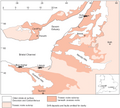 Late Triassic ichthyosaur localities near Bristol Channel–Severn Estuary.png 3 756 × 3 392; 4,33 MB
-
 Looking towards Harworth pit - geograph.org.uk - 1350430.jpg 640 × 480; 53 KB
-
 Man o' War Bay and Durdle Door - geograph.org.uk - 375347.jpg 640 × 427; 63 KB
-
 Muséum de Nantes - 360 - Calcite (Royaume-Uni).jpg 3 684 × 2 848; 1,41 MB
-
 Muséum de Nantes - 361 - Calcite (Royaume-Uni).jpg 3 276 × 2 384; 1,04 MB
-
 Muséum de Nantes - 362 - Calcite (Royaume-Uni).jpg 4 272 × 2 848; 3,48 MB
-
 Muséum de Nantes - 366 - Calcite (Grenoble, France).jpg 3 580 × 2 460; 1,37 MB
-
 Muséum de Nantes - 367 - Calcite (Royaume-Uni).jpg 2 820 × 2 732; 1,11 MB
-
 Muséum de Nantes - 368 - Calcite (Royaume-Uni).jpg 4 272 × 2 848; 3,55 MB
-
 Muséum de Nantes - 616 - Wavellite (Royaume-Uni).jpg 3 112 × 2 388; 1,49 MB
-
 Muséum de Nantes - 617 - Wavellite (Royaume-Uni).jpg 3 776 × 2 844; 1,95 MB
-
 Needle E'e - geograph.org.uk - 3184.jpg 517 × 621; 215 KB
-

-
 Peach 2 (cropped) at Inchnadamph Inn, 1912.jpg 202 × 242; 57 KB
-
 Peach and Horne.jpg 873 × 673; 554 KB
-
 Peach-Horne Monument, Inchnadmaph.jpg 1 944 × 2 592; 1,61 MB
-
 PingoDepression.jpg 1 200 × 684; 300 KB
-
 Pleistocene deposits of the Thames valley. Wellcome M0014956.jpg 4 324 × 2 552; 3,82 MB
-
 Quantocksbeach.jpg 586 × 388; 67 KB
-
 Rainbow at Lion Rock - geograph.org.uk - 360390.jpg 640 × 480; 55 KB
-
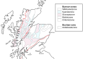 Scotland metamorphic zones NL.svg 1 300 × 900; 221 KB
-
 Scottle Holm - geograph.org.uk - 8709.jpg 640 × 413; 257 KB
-
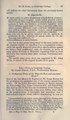
 South end of Lunga - geograph.org.uk - 753629.jpg 640 × 480; 59 KB
-
 Stair Hole - geograph.org.uk - 239036.jpg 640 × 358; 85 KB
-
 Stair Hole from the East. - geograph.org.uk - 200981.jpg 437 × 640; 140 KB
-
 Stranded stack, Bàgh an Dà Dhoruis - geograph.org.uk - 990033.jpg 640 × 480; 74 KB
-
 The age of mammals in Europe, Asia and North America (1910) (17757244990).jpg 1 814 × 1 268; 644 KB
-
 The Blue Pool, Furzebrook - geograph.org.uk - 78921.jpg 640 × 480; 290 KB
-
 The Whale's Mou' - geograph.org.uk - 247948.jpg 640 × 399; 259 KB
-
 The Whale's Mou' - geograph.org.uk - 247956.jpg 640 × 438; 288 KB
-
 Unconformity ingleton twiss 2018.jpg 4 608 × 3 456; 8,08 MB
-
-
 Worm's Head, Gower - geograph.org.uk - 310005.jpg 640 × 480; 60 KB
-
 At Haroldston chins looking north - geograph.org.uk - 66323.jpg 640 × 480; 116 KB
-
 Cracked Boulder - geograph.org.uk - 215877.jpg 640 × 608; 392 KB
-
 Cross-bedding - geograph.org.uk - 215880.jpg 640 × 427; 261 KB
-
 De'il's Heid - geograph.org.uk - 3189.jpg 480 × 640; 47 KB
-
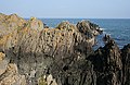
 Devonian Rocks - geograph.org.uk - 215986.jpg 427 × 640; 276 KB
-
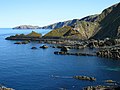
 East Comb - geograph.org.uk - 215983.jpg 427 × 640; 264 KB
-
 Fold at Port Ban - geograph.org.uk - 4334.jpg 446 × 640; 255 KB
-
 Guillemots hiding below the cliffs - geograph.org.uk - 286053.jpg 640 × 451; 91 KB
-
 Landslip above the Pennine Way - geograph.org.uk - 366932.jpg 640 × 480; 68 KB
-
 Natural Arch, Griminish Point - geograph.org.uk - 200633.jpg 640 × 477; 253 KB
-
 Rock Formation at Aberlady Point - geograph.org.uk - 201402.jpg 640 × 427; 116 KB
-
 Rubha Robhanais - geograph.org.uk - 203992.jpg 640 × 389; 223 KB


.jpg)
.jpg)
.jpg)
.jpg)
.jpg)
.jpg)
.jpg)
.jpg)


_at_Inchnadamph_Inn,_1912.jpg)


_(17757244990).jpg)


