Category:Golmés
Zur Navigation springen
Zur Suche springen
| Objektposition | | Karte mit allen Koordinaten: OpenStreetMap |
|---|
Gemeinde in Spanien _02.JPG)   | |||||
| Medium hochladen | |||||
| Ist ein(e) | |||||
|---|---|---|---|---|---|
| Ort | Pla d'Urgell, Provinz Lleida, Katalonien | ||||
| Liegt am oder im Gewässer | |||||
| Hauptstadt |
| ||||
| Amtssprache | |||||
| Leiter der Regierung oder Verwaltung |
| ||||
| Einwohnerzahl |
| ||||
| Fläche |
| ||||
| Höhe über dem Meeresspiegel |
| ||||
| offizielle Website | |||||
 | |||||
Català: Golmés és una vila i municipi de la comarca del Pla d'Urgell
Unterkategorien
Es werden 9 von insgesamt 9 Unterkategorien in dieser Kategorie angezeigt:
In Klammern die Anzahl der enthaltenen Kategorien (K), Seiten (S), Dateien (D)
C
- Coats of arms of Golmés (2 D)
G
- Gegants from Golmés (4 D)
H
- Historical images of Golmés (1 D)
M
- Maps of Golmés (2 D)
V
- Views from Coll de Coma Ermada (15 D)
- Views of Golmés (2 D)
Medien in der Kategorie „Golmés“
Folgende 4 Dateien sind in dieser Kategorie, von 4 insgesamt.
-
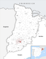 Karte Gemeinde Golmés 2022.png 5.000 × 6.301; 2,91 MB
-
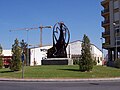 Rotonda de Golmés.jpg 800 × 600; 599 KB
-
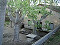
 Saltdelduran.jpg 700 × 465; 44 KB
-
 Saltdelduran2.jpg 1.181 × 886; 1,07 MB


