Category:Great Salt Lake Desert
Zur Navigation springen
Zur Suche springen
Region nahe des Großen Salzsees im US-Bundesstaat Utah  | |||||
| Medium hochladen | |||||
| Ist ein(e) | |||||
|---|---|---|---|---|---|
| Ort |
| ||||
| Besteht aus | |||||
 | |||||
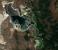
English: The Great Salt Lake Desert — of the Great Basin region in northwest Utah.
- Part of the northwest and west shores of the Great Salt Lake.
Unterkategorien
Es werden 23 von insgesamt 23 Unterkategorien in dieser Kategorie angezeigt:
In Klammern die Anzahl der enthaltenen Kategorien (K), Seiten (S), Dateien (D)
B
C
D
- Dugway Range (1 D)
F
G
H
- Hogup Mountains (7 D)
K
- Knolls, Utah (1 D)
L
- Lakeside Mountains (12 D)
M
- Matlin, Utah (1 D)
- Michael Army Airfield (2 D)
N
- Newfoundland Mountains (8 D)
P
S
- Scranton, Utah (leer)
- Silver Island Mountains (21 D)
T
- Terrace Mountain (Utah) (2 D)
- Terrace, Utah (2 D)
Medien in der Kategorie „Great Salt Lake Desert“
Folgende 48 Dateien sind in dieser Kategorie, von 48 insgesamt.
-

-
 2013-07-04 14 10 07 View of West Wendover in Nevada from a hill to the west.jpg 2.565 × 1.260; 1,61 MB
-

-

-

-
-
-

-

-

-

-

-

-
-
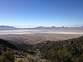
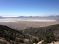
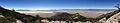
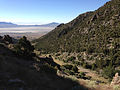
 2014-06-29 16 44 42 Panorama of the Great Salt Lake Desert from Pilot Peak, Nevada.JPG 8.691 × 2.170; 8,65 MB
-
-

-

-

-

-

-

-
-

-
 2015.05.02 12.18.47 DSCN2311 - Flickr - andrey zharkikh.jpg 3.648 × 2.736; 1,71 MB
-
 Aerial view of Newfoundland Mountains from the south dllu.jpg 7.968 × 5.320; 6,66 MB
-
 Butte in Great Salt Lake Desert-750px.JPG 750 × 289; 16 KB
-

-
-
 DeepCreeksSnow.JPG 3.264 × 2.448; 4,69 MB
-
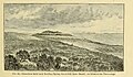 Fig 24 Limestone butte near Redding Spring.jpg 1.099 × 645; 183 KB
-
 Fig 25 Compund Hook of an Intermediate Shore-line near Willow Spring,.jpg 1.103 × 794; 155 KB
-
 Fish Springs Utah.jpg 3.264 × 2.448; 1,4 MB
-
 Great Salt Lake accounting unit (watershed).png 99 × 129; 2 KB
-
 Great Salt Lake, Utah - World Wind image.png 1.278 × 722; 1,87 MB
-
 ISS031-E-146395 - View of Utah.jpg 4.288 × 2.848; 1,4 MB
-
 MiddleSpring.JPG 3.264 × 2.448; 2,74 MB
-

-
 Panorama of the Great Salt Lake Desert.jpg 2.696 × 400; 102 KB
-
 PilotPeakNV.jpg 997 × 600; 51 KB
-
 Plate 36 View on Great Salt Lake Desert.jpg 1.807 × 1.131; 209 KB
-
 Bonneville salt flats pilot peak.jpg 3.888 × 2.592; 2,9 MB
-
 Sl-1-ineel61-667.jpg 1.261 × 884; 278 KB
-
 Tooelecounty.png 1.024 × 827; 149 KB
-
 Tree of Life - panoramio (1).jpg 3.000 × 4.000; 3,9 MB
-
 Utahgeography.jpg 1.200 × 1.200; 661 KB
-
 View from Pilot Peak in Nevada.JPG 4.272 × 2.848; 3,61 MB
-
 Wasatchfrontfromspace.jpg 431 × 372; 125 KB


.png)


.jpg)


.jpg)


Kategorien:
- Deserts of Utah
- Great Basin region of Utah
- Landforms bordering the Great Salt Lake
- Regions of Utah
- Landforms of Box Elder County, Utah
- Landforms of Juab County, Utah
- Landforms of Tooele County, Utah
- Locations along Interstate 80 in Tooele County, Utah
- Locations along Utah State Route 4 (1910-1962) in Tooele County, Utah
- Locations along Utah State Route 30 in Box Elder County, Utah
- Locations along Utah State Route 70 (1931-1977)