Category:Great Witchingham
Aller à la navigation
Aller à la recherche
English: Great Witchingham is a village and civil parish in the English county of Norfolk about north-west of Norwich.
localité britannique du comté anglais de Norfolk _optimized_and_spun.jpg) | |||||
| Téléverser des médias | |||||
| Nature de l’élément | |||||
|---|---|---|---|---|---|
| Lieu | Broadland, Norfolk, Angleterre de l'Est, Angleterre | ||||
| Superficie |
| ||||
 | |||||
Sous-catégories
Cette catégorie comprend 6 sous-catégories, dont les 6 ci-dessous.
Média dans la catégorie « Great Witchingham »
Cette catégorie comprend 45 fichiers, dont les 45 ci-dessous.
-
 A1067 approaching crossroads at Lenwade - geograph.org.uk - 3843543.jpg 3 088 × 2 056 ; 2,29 Mio
-
 A1067 entering Lenwade - geograph.org.uk - 3843535.jpg 1 024 × 673 ; 140 kio
-
 A1067 into Lenwade - geograph.org.uk - 3845714.jpg 800 × 564 ; 133 kio
-
 A1067 towards Lenwade - geograph.org.uk - 3841838.jpg 1 024 × 701 ; 145 kio
-
 Blackwater Lane towards Sparham - geograph.org.uk - 5007303.jpg 2 092 × 1 336 ; 2,58 Mio
-
 Eade's Mill House - geograph.org.uk - 1254851.jpg 620 × 550 ; 107 kio
-
 Five Way Crossroads on Nowhere Lane - geograph.org.uk - 2526888.jpg 3 072 × 2 304 ; 1,5 Mio
-
 Furze Lane - geograph.org.uk - 5010118.jpg 2 005 × 1 365 ; 2,11 Mio
-
 Gabions creating sheltered seating near Lenwade War Memorial - geograph.org.uk - 5957843.jpg 3 456 × 2 592 ; 3,97 Mio
-
 Great Witchingham - geograph.org.uk - 73604.jpg 640 × 480 ; 119 kio
-
 Heath Lane near Great Witchingham - geograph.org.uk - 5007287.jpg 1 990 × 1 289 ; 2,45 Mio
-
 Lenwade Mill on the R Wensum - geograph.org.uk - 6014001.jpg 5 184 × 2 920 ; 6,63 Mio
-
 Manor Farm - geograph.org.uk - 454645.jpg 640 × 480 ; 88 kio
-
 New housing, Lenwade - geograph.org.uk - 4435811.jpg 640 × 480 ; 335 kio
-
 Norfolk Wildlife Park in the late seventies - geograph.org.uk - 1448907.jpg 640 × 429 ; 155 kio
-
 Nowhere Lane sign - geograph.org.uk - 2526890.jpg 3 072 × 2 304 ; 1,56 Mio
-
 Pine trees beside Fakenham Road (A1067) - geograph.org.uk - 3935038.jpg 640 × 480 ; 274 kio
-
 Poppies in a field near Great Witchingham - geograph.org.uk - 5003125.jpg 2 256 × 1 496 ; 916 kio
-
 Road from Church Farm - geograph.org.uk - 5551114.jpg 1 600 × 1 200 ; 463 kio
-
 Royal Observer Corps post by Great Witchingham - geograph.org.uk - 3935049.jpg 800 × 754 ; 401 kio
-
 Royal Observer Corps post by Great Witchingham - geograph.org.uk - 3935055.jpg 800 × 677 ; 315 kio
-
 Royal Observer Corps post by Great Witchingham - geograph.org.uk - 3935058.jpg 800 × 633 ; 359 kio
-

-

-
 Sliding door and exit onto the roof - geograph.org.uk - 3935946.jpg 640 × 480 ; 76 kio
-
 St. Faith's church, Lenwade - geograph.org.uk - 2308897.jpg 640 × 480 ; 87 kio
-
 St. Faith's church, Lenwade - geograph.org.uk - 2308901.jpg 640 × 480 ; 96 kio
-
 Switchboard and connector box - geograph.org.uk - 3935944.jpg 480 × 640 ; 71 kio
-
 The Bridge at Lenwade - geograph.org.uk - 3110903.jpg 3 456 × 2 304 ; 1,36 Mio
-
 The new village hall at Great Witchingham (geograph 4435810).jpg 640 × 480 ; 326 kio
-
 The new village hall at Great Witchingham (geograph 4435813).jpg 640 × 480 ; 359 kio
-
 The new village hall at Great Witchingham (geograph 4435814).jpg 640 × 480 ; 322 kio
-
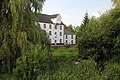 The Old Mill, Lenwade - geograph.org.uk - 3110911.jpg 3 456 × 2 304 ; 2,37 Mio
-
 Two wooden crosses and a porcelain mug - geograph.org.uk - 3935045.jpg 640 × 480 ; 255 kio
-
 Unnamed lane near Great Witchingham (geograph 5007295).jpg 2 256 × 1 496 ; 2,37 Mio
-
 Unnamed lane near Great Witchingham - geograph.org.uk - 5007300.jpg 2 200 × 1 468 ; 2,76 Mio
-
 Unnamed Lane near Little Witchingham Hall (geograph 5006608).jpg 2 152 × 1 383 ; 1,56 Mio
-
 View along Fakenham Road (A1067) - geograph.org.uk - 3935042.jpg 640 × 480 ; 234 kio
-
 View from the top - geograph.org.uk - 3935950.jpg 640 × 480 ; 52 kio
-
 War memorial, Lenwade - geograph.org.uk - 4435815.jpg 488 × 532 ; 320 kio
-
 War memorial, Lenwade - geograph.org.uk - 4435816.jpg 480 × 640 ; 362 kio
-
 War memorial, Lenwade - geograph.org.uk - 4435817.jpg 480 × 640 ; 363 kio
-
 Weak bridge recently repaired - geograph.org.uk - 552124.jpg 640 × 480 ; 137 kio
-
 Weary sign on a long-distance path - geograph.org.uk - 552126.jpg 640 × 480 ; 209 kio
-
 Woodland and fields from path, Fiddler's Hill - geograph.org.uk - 4017481.jpg 3 264 × 2 448 ; 3,04 Mio


_-_geograph.org.uk_-_3935038.jpg)


_past_Sparham_-_geograph.org.uk_-_2530556.jpg)


.jpg)
.jpg)
.jpg)


.jpg)

.jpg)
_-_geograph.org.uk_-_3935042.jpg)


