Category:Greater Los Angeles Area
둘러보기로 이동
검색으로 이동
large urban region in the United States   .jpg)  | |||||
| 미디어 올리기 | |||||
| 다음 종류에 속함 |
| ||||
|---|---|---|---|---|---|
| 위치 | 캘리포니아주, Pacific States Region | ||||
| 인구수 |
| ||||
| 다음과 다름 | |||||
 | |||||
"Greater Los Angeles Area" 분류에 속하는 미디어
다음은 이 분류에 속하는 파일 25개 가운데 25개입니다.
-
 Map of the USA highlighting the Greater Los Angeles Area.gif 4,200 × 3,105; 1.53 MB
-
 BajaltaCalif.jpg 2,246 × 1,433; 634 KB
-
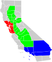
 California extended metropolitan areas locator map (gray).png 1,708 × 2,232; 807 KB
-
 California geographical region county map.svg 621 × 733; 258 KB
-
 Consulate General Los Angeles Skyline.jpg 4,032 × 2,268; 1.81 MB
-
-
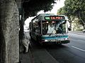 Foothill Transit - Bus Number 486 to Cal-Poly State U.jpg 800 × 600; 255 KB
-
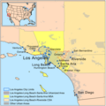
 Greater Los Angeles Area.png 1,500 × 826; 424 KB
-
-
 GreaterLAmap.png 1,000 × 1,000; 621 KB
-
 ISS030-E-222910 - View of Earth.jpg 4,256 × 2,832; 748 KB
-
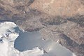 ISS048-E-23587 - View of Earth.jpg 4,928 × 3,280; 1.64 MB
-
 ISS048-E-47528 - View of Earth.jpg 4,928 × 3,280; 1.74 MB
-
 LA State Compensation Insurance Fund.jpg 1,053 × 1,374; 458 KB
-
 Los Angeles CSA urban areas.svg 1,022 × 600; 1.44 MB
-
 Los Angeles CSA.svg 977 × 707; 253 KB
-
 Los Angeles Freeway Map.png 583 × 482; 162 KB
-
 Los Angeles satellite map.jpg 576 × 854; 87 KB
-
 Los Angeles tiny eddy.jpg 420 × 420; 56 KB
-
 Los Angeles–Long Beach, CA CSA.png 1,217 × 2,163; 697 KB
-
 Pacific Coast Highway, Greater LA.jpg 4,032 × 3,024; 2.77 MB
-
 Santa Ana winds - satellite image.jpg 1,470 × 1,701; 327 KB
-
 Santa Monica Bay Map.jpg 468 × 597; 283 KB
-
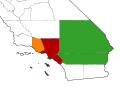
 California SD-29 (2011).svg 1,450 × 1,680; 55 KB
-
 Ywca logo.jpg 271 × 186; 7 KB


.png)


.jpg)


.svg)