Category:Green Line A branch
Zur Navigation springen
Zur Suche springen
Bahnhof in den Vereinigten Staaten  | |||||
| Medium hochladen | |||||
| Ist ein(e) | |||||
|---|---|---|---|---|---|
| Ist Teil von | |||||
| Ort | Boston, Suffolk County, Massachusetts | ||||
| Eröffnungsdatum |
| ||||
| Schließungsdatum |
| ||||
| Endpunkt (Objekt) | |||||
| Ersetzt durch | |||||
| |||||
English: The Green Line A branch lasted only until 1969, with shop moves lasting until the early 1990s. Current photos of the Commonwealth Avenue trackage and stations should be categorized under Category:Green Line B branch; only maps and photographs specifically dealing with Watertown Line infrastructure, along with any old photographs of Watertown-signed streetcars, should be placed here.
Unterkategorien
Es werden 9 von insgesamt 9 Unterkategorien in dieser Kategorie angezeigt:
In Klammern die Anzahl der enthaltenen Kategorien (K), Seiten (S), Dateien (D)
*
- Green Line A branch trains (20 D)
5
- 501 (MBTA bus) (10 D)
- 502 (MBTA bus) (4 D)
- 503 (MBTA bus) (1 D)
- 504 (MBTA bus) (10 D)
P
- Packards Corner junction (6 D)
W
Medien in der Kategorie „Green Line A branch“
Folgende 6 Dateien sind in dieser Kategorie, von 6 insgesamt.
-
 Brighton Avenue looking west at Chester Street, April 1948.jpg 1.499 × 1.209; 211 KB
-
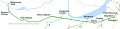 Green Line A Branch map.svg 3.200 × 750; 147 KB
-
 Green Line branches.jpg 1.966 × 1.312; 995 KB
-
 Location of Oak Square loop in 2013.JPG 4.320 × 3.240; 2,53 MB
-
 Trolley pole in Oak Square, January 2016.JPG 3.240 × 4.320; 3,54 MB
-


.jpg)