Category:Gschwandt bei Gmunden
Vai alla navigazione
Vai alla ricerca
comune austriaco  Ortszentrum von Gschwandt  | |||||
| Carica un file multimediale | |||||
| Istanza di |
| ||||
|---|---|---|---|---|---|
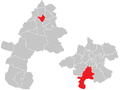
| Luogo | distretto di Gmunden, Alta Austria, Austria | ||||
| Popolazione |
| ||||
| Superficie |
| ||||
| Altezza sul mare |
| ||||
| Distinto da | |||||
| sito web ufficiale | |||||
 | |||||
Sottocategorie
Questa categoria contiene le 2 sottocategorie indicate di seguito, su un totale di 2.
C
P
File nella categoria "Gschwandt bei Gmunden"
Questa categoria contiene 30 file, indicati di seguito, su un totale di 30.
-
 20240509-bücherzelle-laakirchner-straße-gschwandt-bei-gmunden.jpg 3 060 × 4 080; 4,05 MB
-
 Gmunden Marienstatue Wasserloser Bach.jpg 1 343 × 2 414; 1,5 MB
-
 Grenzmarke in Gschwandt bei Gmunden.jpg 2 225 × 2 959; 2,16 MB
-
 Gschwand Jauchebottich einsetzen 1935a.jpg 962 × 668; 482 KB
-
 Gschwand Jauchebottich einsetzen 1935b.jpg 946 × 567; 363 KB
-
 Gschwand Teufelkasten 1935.jpg 592 × 843; 316 KB
-
 Gschwandt bei Gmunden - Ortszentrum.JPG 4 370 × 2 397; 9,93 MB
-
 Gschwandt bei Gmunden Wegkreuz.jpg 2 295 × 3 256; 2,67 MB
-
 Gschwandt bei Gmunden.JPG 3 072 × 2 048; 1,46 MB
-
 Gschwandt Bildstock Steinbichl.jpg 2 247 × 3 145; 2,11 MB
-
 Gschwandt im Bezirk GM.png 645 × 645; 23 KB
-
 Gschwandt in GM.png 500 × 375; 13 KB
-
 Gschwandt Kruzifix ab Pfarrkirche.jpg 1 875 × 2 993; 1,18 MB
-
 Gschwandt Moos EK.JPG 3 415 × 2 280; 3,16 MB
-
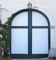 Gschwandt Portal.JPG 2 155 × 2 281; 1,64 MB
-
 Gschwandt Wegkapelle Baumgarten.jpg 2 374 × 1 998; 1,29 MB
-
 Gschwandt Wegkapelle Leitenbauernweg.jpg 1 805 × 2 320; 2,23 MB
-
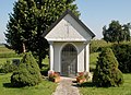
 Gschwandt Wegkapelle Moosham.jpg 3 169 × 2 392; 2,37 MB
-
 Gschwandt Wegkapelle St. Leonhard.jpg 3 070 × 2 227; 1,84 MB
-
 Gschwandt Wegkreuz Altmanninger.jpg 2 075 × 2 854; 2,05 MB
-
 Gschwandt Wegkreuz Maierhof.jpg 1 872 × 2 789; 1,8 MB
-
 Gschwandt Wegkreuz Rabesberg.jpg 1 977 × 2 440; 2,02 MB
-
 Gschwandt-Schule Traunseebahn.JPG 3 057 × 2 041; 2,5 MB
-
 Gschwandt.JPG 5 669 × 3 607; 15,76 MB
-
 Karl z'Neuhub Traunseebahn.JPG 3 977 × 2 665; 4,84 MB
-
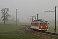
 Morning fog. - Flickr - Simon Matzinger.jpg 10 368 × 7 776; 16,57 MB
-
 Neuhub Traunseebahn.JPG 3 874 × 2 586; 3,79 MB
-
 Neuhub-23-112.jpg 1 200 × 800; 726 KB
-
 StH Traunseebahn Wartehaus.JPG 3 072 × 2 304; 2,09 MB
-
 Wappen at gschwandt.png 166 × 207; 2 KB


