Category:Halwill
Aller à la navigation
Aller à la recherche
village britannique  | |||||
| Téléverser des médias | |||||
| Nature de l’élément | |||||
|---|---|---|---|---|---|
| Lieu | Torridge, Devon, Angleterre du Sud-Ouest, Angleterre | ||||
 | |||||
Sous-catégories
Cette catégorie comprend 3 sous-catégories, dont les 3 ci-dessous.
H
S
- Stowford, Halwill (2 F)
Média dans la catégorie « Halwill »
Cette catégorie comprend 118 fichiers, dont les 118 ci-dessous.
-
 A3079 at Halwill Junction - geograph.org.uk - 3664491.jpg 1 600 × 996 ; 174 kio
-
 A3079 Lane End - geograph.org.uk - 3288551.jpg 640 × 480 ; 91 kio
-
 A3079 Metherell Cross - geograph.org.uk - 3664467.jpg 800 × 544 ; 78 kio
-
 A3079 near Halwill Moor Plantation - geograph.org.uk - 3664500.jpg 1 024 × 587 ; 100 kio
-
 A3079 roundabout at Halwill Junction - geograph.org.uk - 3631227.jpg 1 600 × 1 030 ; 231 kio
-
 A3079 south of Halwill Junction - geograph.org.uk - 3631241.jpg 1 669 × 1 047 ; 838 kio
-
 A3079 towards Halwill Junction - geograph.org.uk - 3664497.jpg 1 024 × 658 ; 123 kio
-
 Access road to Rowden Farm - geograph.org.uk - 5018087.jpg 1 600 × 1 200 ; 814 kio
-
 Approaching Halwill from the northeast - geograph.org.uk - 3425758.jpg 848 × 636 ; 143 kio
-
 Approaching Halwill Mill - geograph.org.uk - 5000456.jpg 1 920 × 1 255 ; 826 kio
-
 Approaching Stowford - geograph.org.uk - 4865616.jpg 2 323 × 1 356 ; 759 kio
-
 Base of cross in Halwill churchyard - geograph.org.uk - 3705470.jpg 640 × 480 ; 111 kio
-
 Beaworthy Post Office - geograph.org.uk - 3704809.jpg 640 × 480 ; 58 kio
-
 Beaworthy Post Office - geograph.org.uk - 5660402.jpg 1 024 × 768 ; 141 kio
-
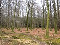 Beech trees in Halwill Moor Plantation - geograph.org.uk - 3704336.jpg 640 × 480 ; 137 kio
-
 Beeching Close - geograph.org.uk - 5541627.jpg 1 024 × 768 ; 124 kio
-
 Beeching Close at Halwill Junction - geograph.org.uk - 3704801.jpg 640 × 480 ; 62 kio
-
 Bridge over a small stream near Caradon View - geograph.org.uk - 2984279.jpg 800 × 600 ; 424 kio
-
 Bridge over a stream, Halwill - geograph.org.uk - 1806968.jpg 2 000 × 1 500 ; 1,02 Mio
-
 Bridleway at Greenacres Farm - geograph.org.uk - 468947.jpg 640 × 480 ; 142 kio
-
 Bridleway round Stonequarry Farm - geograph.org.uk - 514145.jpg 640 × 480 ; 130 kio
-
 Broadbury - geograph.org.uk - 4865540.jpg 3 056 × 1 867 ; 1,08 Mio
-
 Bus shelter at Halwill Junction - geograph.org.uk - 5753020.jpg 1 600 × 1 199 ; 725 kio
-
 Chapel Farm - geograph.org.uk - 488159.jpg 640 × 480 ; 104 kio
-
 Cookworthy Forest - geograph.org.uk - 6210216.jpg 1 600 × 1 067 ; 662 kio
-
 Cookworthy Forest Trail - geograph.org.uk - 6210188.jpg 1 600 × 1 067 ; 741 kio
-
 Derelict greenhouse, Winsford Walled Garden, Beaworthy - geograph.org.uk - 1806747.jpg 2 000 × 1 500 ; 1,11 Mio
-
 Dewy bridleway - geograph.org.uk - 514208.jpg 480 × 640 ; 140 kio
-
 Diverted bridleway - geograph.org.uk - 513433.jpg 640 × 480 ; 152 kio
-
 Dreybury Lane - geograph.org.uk - 513400.jpg 480 × 640 ; 86 kio
-
 Dreybury Lane - geograph.org.uk - 513427.jpg 640 × 480 ; 125 kio
-
 Entry to Cookworthy Forest - geograph.org.uk - 6210190.jpg 1 600 × 1 067 ; 988 kio
-
 Field between Halwill and Lane End - geograph.org.uk - 3705498.jpg 640 × 480 ; 54 kio
-
 Field near Foxhole - geograph.org.uk - 468918.jpg 640 × 480 ; 132 kio
-
 Field near Stonequarry Farm - geograph.org.uk - 511581.jpg 640 × 480 ; 131 kio
-
 First World War memorial, Halwill Junction - geograph.org.uk - 5660799.jpg 1 024 × 780 ; 214 kio
-
 Flowers along Dreybury Lane - geograph.org.uk - 513483.jpg 640 × 480 ; 134 kio
-
 Forest road in Halwill Moor Plantation - geograph.org.uk - 3704333.jpg 640 × 480 ; 69 kio
-
 Former railway bridge on A3079 near Lane End - geograph.org.uk - 5753025.jpg 1 600 × 800 ; 598 kio
-
 Former school, Halwill - geograph.org.uk - 1806957.jpg 2 000 × 1 369 ; 748 kio
-
 Foxhole Bridge - geograph.org.uk - 468914.jpg 480 × 640 ; 138 kio
-
 Gentle slope for A3079 near Henderbarrow - geograph.org.uk - 5753012.jpg 1 600 × 1 201 ; 771 kio
-
 Gravestones, Halwill - geograph.org.uk - 488310.jpg 640 × 480 ; 141 kio
-
 Halwill Baptist church - geograph.org.uk - 5541618.jpg 1 024 × 768 ; 154 kio
-
 Halwill Bridleway 11 - geograph.org.uk - 514214.jpg 480 × 640 ; 95 kio
-
 Halwill Church in the May sunshine - geograph.org.uk - 2927104.jpg 640 × 427 ; 143 kio
-
 Halwill Junction Baptist church - geograph.org.uk - 2944231.jpg 800 × 600 ; 371 kio
-
 Halwill Junction entrance sign - geograph.org.uk - 2424773.jpg 640 × 434 ; 61 kio
-
 Halwill Junction Inn - geograph.org.uk - 2927191.jpg 640 × 417 ; 71 kio
-
 Halwill Moor Plantation - geograph.org.uk - 468334.jpg 640 × 480 ; 120 kio
-
 Halwill Parish Hall - geograph.org.uk - 5660380.jpg 1 024 × 662 ; 95 kio
-
 Halwill village - geograph.org.uk - 2927144.jpg 640 × 427 ; 98 kio
-
 Halwillmap 1946.png 720 × 804 ; 749 kio
-
 Henderbarrow Corner - geograph.org.uk - 4309198.jpg 640 × 480 ; 111 kio
-
 Henderbarrow Corner A3079 - geograph.org.uk - 3288548.jpg 640 × 527 ; 122 kio
-
 Lane near Foxhole - geograph.org.uk - 468915.jpg 640 × 480 ; 126 kio
-
 Lane to Halwill Mill - geograph.org.uk - 4865644.jpg 2 825 × 1 499 ; 1,18 Mio
-
 Lane to Halwill Mill - geograph.org.uk - 5000448.jpg 1 920 × 1 079 ; 758 kio
-
 Lane, Halwill - geograph.org.uk - 1807011.jpg 2 000 × 1 500 ; 954 kio
-
 Narrow tree-lined road with ditches east of Upcott Cross - geograph.org.uk - 5018084.jpg 1 600 × 1 200 ; 835 kio
-
 Near Henderbarrow Farm - geograph.org.uk - 487928.jpg 640 × 480 ; 137 kio
-
 Near Rectory - geograph.org.uk - 488313.jpg 640 × 480 ; 126 kio
-

-
 Old rail track in Halwill Moor Plantation - geograph.org.uk - 511619.jpg 640 × 480 ; 122 kio
-

-
 Path Junction - geograph.org.uk - 6210202.jpg 1 600 × 1 067 ; 705 kio
-
 Path to Halwill Junction - geograph.org.uk - 4947969.jpg 1 600 × 1 067 ; 1,07 Mio
-
 Path to Halwill Moor Plantation - geograph.org.uk - 4947983.jpg 1 600 × 1 067 ; 731 kio
-
 Public Conveniences, Halwill Junction - geograph.org.uk - 5660397.jpg 1 024 × 768 ; 187 kio
-
 Remains of railway bridge - geograph.org.uk - 4948272.jpg 1 600 × 1 067 ; 856 kio
-
 Ride through Halwill Moor Plantation - geograph.org.uk - 513497.jpg 480 × 640 ; 144 kio
-
 River Carey - geograph.org.uk - 471474.jpg 640 × 480 ; 138 kio
-
 Road across Broadbury - geograph.org.uk - 487823.jpg 640 × 480 ; 131 kio
-
 Road across Broadbury - geograph.org.uk - 5000433.jpg 1 920 × 1 078 ; 962 kio
-
 Road on Broadbury - geograph.org.uk - 468920.jpg 640 × 480 ; 130 kio
-
 Road to Metehrell Farm and campsite - geograph.org.uk - 5018102.jpg 1 600 × 1 200 ; 767 kio
-
 Roundabout in Halwill Junction - geograph.org.uk - 2984281.jpg 800 × 600 ; 319 kio
-
 Sewage works, Halwill - geograph.org.uk - 1807018.jpg 2 000 × 1 498 ; 800 kio
-
 Shared path to Cookworthy Forest - geograph.org.uk - 6210198.jpg 1 600 × 1 067 ; 781 kio
-
 Signpost at Halwill Junction crossroads - geograph.org.uk - 5560123.jpg 800 × 600 ; 118 kio
-
 Signs and War Memorial at Halwill Junction - geograph.org.uk - 2927206.jpg 640 × 467 ; 101 kio
-
 St Peter ^ St James church, Halwill - geograph.org.uk - 3220912.jpg 1 600 × 1 067 ; 412 kio
-
 Start of path to Halwill Moor Plantation - geograph.org.uk - 4947973.jpg 1 600 × 1 067 ; 789 kio
-
 Station Fields, once the railway station - geograph.org.uk - 2927217.jpg 640 × 427 ; 67 kio
-
 Station Road (A3079) at Halwill Junction - geograph.org.uk - 3420061.jpg 750 × 562 ; 119 kio
-
 Stonequarry Farm - geograph.org.uk - 514157.jpg 640 × 480 ; 113 kio
-
 The A3079 - geograph.org.uk - 2927183.jpg 640 × 427 ; 75 kio
-
 The A3079 nr Lane End - geograph.org.uk - 2927220.jpg 640 × 427 ; 95 kio
-
 The bamboo grove, Winsford Walled Garden, Beaworthy - geograph.org.uk - 1806728.jpg 2 000 × 1 468 ; 1,24 Mio
-

-
 The church of St Peter and St Paul at Halwill - geograph.org.uk - 3420032.jpg 637 × 477 ; 112 kio
-
 The end of Beeching Close - geograph.org.uk - 2944245.jpg 800 × 600 ; 289 kio
-
 The Junction Inn - geograph.org.uk - 5660372.jpg 1 024 × 768 ; 164 kio
-
 The Junction Inn at Halwill Junction - geograph.org.uk - 2944238.jpg 800 × 600 ; 301 kio
-
 The Junction Inn at Halwill Junction - geograph.org.uk - 3704797.jpg 640 × 480 ; 62 kio
-

-
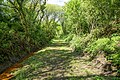
 The Ruby Trail - geograph.org.uk - 511639.jpg 640 × 480 ; 119 kio
-
 Torridge , Angler's Paradise - geograph.org.uk - 5447693.jpg 5 074 × 2 854 ; 7,37 Mio
-
 Torridge , Angler's Paradise - geograph.org.uk - 5447696.jpg 4 963 × 2 792 ; 6,03 Mio
-
 Torridge , Angler's Paradise Car Park - geograph.org.uk - 5447694.jpg 5 312 × 2 988 ; 4,62 Mio
-
 Torridge , Road - geograph.org.uk - 5447700.jpg 5 312 × 2 988 ; 5,63 Mio
-
 Torridge , Winsford Lane - geograph.org.uk - 5447691.jpg 5 312 × 2 988 ; 3,98 Mio
-
 Torridge , Winsford Lane - geograph.org.uk - 5447698.jpg 4 859 × 2 733 ; 6,65 Mio
-
 Track to Halwill Moor Plantation - geograph.org.uk - 4961723.jpg 1 600 × 1 067 ; 758 kio
-
 Trackbed of the Halwill to Launceston Branch - geograph.org.uk - 4961708.jpg 1 600 × 1 067 ; 1,13 Mio
-
 Trees and a field entrance south of Upcott Cross - geograph.org.uk - 5018069.jpg 1 600 × 1 200 ; 783 kio
-
 Upcott Cross - geograph.org.uk - 491568.jpg 640 × 480 ; 106 kio
-
 Upcott Cross down to one finger - geograph.org.uk - 3288545.jpg 640 × 480 ; 89 kio
-
 Upcott Plantations - geograph.org.uk - 5018072.jpg 1 200 × 1 600 ; 796 kio
-
 View from Barn Park - geograph.org.uk - 488307.jpg 640 × 361 ; 81 kio
-
 View from Stowford - geograph.org.uk - 4865592.jpg 1 587 × 737 ; 219 kio
-
 Village stores, Halwill Junction - geograph.org.uk - 5660399.jpg 1 024 × 768 ; 130 kio
-
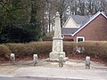 War Memorial at Halwill Junction - geograph.org.uk - 3704768.jpg 640 × 480 ; 106 kio
-
 Warning signs on A3079 - geograph.org.uk - 2984280.jpg 800 × 600 ; 303 kio
-
 Wayside cross near Halwill church - geograph.org.uk - 3705449.jpg 640 × 480 ; 88 kio
-
 Whiteleigh Plantation - geograph.org.uk - 513504.jpg 640 × 480 ; 147 kio
-
 Whiteleigh Plantation - geograph.org.uk - 513508.jpg 640 × 480 ; 127 kio
-
 Winsford Walled Garden, Beaworthy - geograph.org.uk - 1806835.jpg 2 000 × 1 500 ; 1,23 Mio


_at_Halwill_Junction_-_geograph.org.uk_-_3420061.jpg)


