Category:Haut-Intyamon
Zur Navigation springen
Zur Suche springen
Français : Haut-Intyamon est une commune du district de la Gruyère dans le canton de Fribourg en Suisse.
Gemeinde im Kanton Freiburg in der Schweiz    | |||||
| Medium hochladen | |||||
| Ist ein(e) | |||||
|---|---|---|---|---|---|
| Ort | Greyerzbezirk, Kanton Freiburg, Schweiz | ||||
| Liegt am oder im Gewässer | |||||
| Amtssprache | |||||
| Einwohnerzahl |
| ||||
| Fläche |
| ||||
| Höhe über dem Meeresspiegel |
| ||||
| Ersetzt |
| ||||
| offizielle Website | |||||
 | |||||
Unterkategorien
Es werden 11 von insgesamt 11 Unterkategorien in dieser Kategorie angezeigt:
In Klammern die Anzahl der enthaltenen Kategorien (K), Seiten (S), Dateien (D)
Medien in der Kategorie „Haut-Intyamon“
Folgende 41 Dateien sind in dieser Kategorie, von 41 insgesamt.
-
 CHE Haut-Intyamon Flag.svg 500 × 503; 25 KB
-
 Cow (14128110910).jpg 3.456 × 5.184; 5,3 MB
-
 Cow (14311406801).jpg 3.456 × 5.184; 5,24 MB
-
 Cow (14314737365).jpg 3.456 × 5.184; 5,36 MB
-
 Cow (14334939863).jpg 3.456 × 5.184; 6,11 MB
-
 Cow near Combe d'Allières (14417724173).jpg 5.184 × 3.456; 8,58 MB
-
 Flag of Haut-Intyamon (01 January 2002).gif 216 × 216; 8 KB
-
 Haut-Intyamon CoA.png 193 × 220; 12 KB
-
 Haut-Intyamon-coat of arms.svg 603 × 763; 16 KB
-
 Karte Gemeinde Haut-Intyamon 2007.png 1.181 × 1.215; 388 KB
-
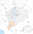 Karte Gemeinde Haut-Intyamon 2014.png 1.476 × 1.519; 668 KB
-
 Karte Gemeinde Haut-Intyamon.png 944 × 972; 241 KB
-
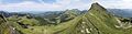
 Near the Col de Lys - panoramio.jpg 5.184 × 3.456; 9,67 MB
-
 Panoramic view at the Col de Lys - panoramio (1).jpg 10.121 × 4.118; 21,82 MB
-
 Panoramic view at the Col de Lys - panoramio.jpg 16.967 × 2.511; 21,58 MB
-
 Panoramic view from Mys Derrey - panoramio.jpg 13.881 × 3.601; 23,38 MB
-
 Panoramic view from the Col de Lys - panoramio (1).jpg 18.104 × 2.508; 17,7 MB
-
 Panoramic view from the Col de Lys - panoramio.jpg 14.498 × 2.623; 18,63 MB
-
 Panoramic view from the Col de Pierra Perchia - panoramio (5).jpg 7.768 × 4.206; 19,74 MB
-
 Panoramic view from the Dent de Jaman (13305926425).jpg 15.019 × 4.168; 60,65 MB
-
 Panoramic view from the Dent de Lys - panoramio (1).jpg 13.903 × 3.596; 23,66 MB
-
 Panoramic view from the Dent de Lys - panoramio (2).jpg 13.851 × 3.609; 24,24 MB
-
 Panoramic view from the Dent de Lys - panoramio.jpg 14.524 × 3.442; 23,99 MB
-
 Panoramic view near Mys Derrey - panoramio (1).jpg 16.927 × 2.953; 22,02 MB
-
 Panoramic view near Mys Derrey - panoramio.jpg 15.576 × 3.209; 22,02 MB
-
 Panoramic view near the Combe d'Allières - panoramio (1).jpg 10.529 × 4.384; 23,85 MB
-
 Panoramic view near the Combe d'Allières - panoramio.jpg 11.935 × 3.977; 21,76 MB
-
 Panoramic view near the Dent de Lys - panoramio.jpg 15.532 × 3.219; 21,75 MB
-
 Panoramic view near the Joux des Heures - panoramio.jpg 13.240 × 3.600; 22,02 MB
-
 Poet's Daffodil - Narcissus poeticus - panoramio.jpg 3.456 × 5.184; 3,86 MB
-
 Red Kite circling near Motélon d'Avau.jpg 2.048 × 1.167; 625 KB
-
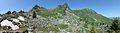
 Rocks at the Rochers de Naye - panoramio (1).jpg 3.456 × 5.184; 8,39 MB
-
 Rocks at the Rochers de Naye - panoramio.jpg 3.456 × 5.184; 8,47 MB
-
 Rocks near the Rochers de Naye - panoramio.jpg 5.184 × 3.456; 7,65 MB
-
 Round-headed Rampion - Phyteuma orbiculare (14312888982).jpg 5.184 × 3.456; 3,87 MB
-
 Schweiz Unterwegs 160DSC 0217 (48436947096).jpg 1.618 × 1.081; 380 KB
-
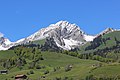 Vanil des Artses (14220089715).jpg 5.184 × 3.456; 7,65 MB
-
 View on the mountains near Les Cases (13305975145).jpg 3.456 × 5.184; 8,62 MB
-
 View on the mountains near Les Cases (13306127023).jpg 3.456 × 5.184; 10,52 MB
-
 View on the mountains near Les Cases (13306337484).jpg 5.184 × 3.456; 6,83 MB
-
 View on the mountains near Les Cases - panoramio.jpg 3.456 × 5.184; 10,52 MB

.jpg)
.jpg)
.jpg)
.jpg)
.jpg)
.gif)


.jpg)
.jpg)


.jpg)


.jpg)
.jpg)
.jpg)
.jpg)
.jpg)
.jpg)

.jpg)
.jpg)
.jpg)
.jpg)
.jpg)
.jpg)