Category:Highland County, Virginia
Vai alla navigazione
Vai alla ricerca
Counties of Virginia: Accomack · Albemarle · Alleghany · Amelia · Amherst · Appomattox · Arlington · Augusta · Bath · Bedford · Bland · Botetourt · Brunswick · Buchanan · Buckingham · Campbell · Caroline · Carroll · Charles City · Charlotte · Chesterfield · Clarke · Craig · Culpeper · Cumberland · Dickenson · Dinwiddie · Essex · Fairfax · Fauquier · Floyd · Fluvanna · Franklin · Frederick · Giles · Gloucester · Goochland · Grayson · Greene · Greensville · Halifax · Hanover · Henrico · Henry · Highland · Isle of Wight · James City · King and Queen · King George · King William · Lancaster · Lee · Loudoun · Louisa · Lunenburg · Madison · Mathews · Mecklenburg · Middlesex · Montgomery · Nelson · New Kent · Northampton · Northumberland · Nottoway · Orange · Page · Patrick · Pittsylvania · Powhatan · Prince Edward · Prince George · Prince William · Pulaski · Rappahannock · Richmond · Roanoke · Rockbridge · Rockingham · Russell · Scott · Shenandoah · Smyth · Southampton · Spotsylvania · Stafford · Surry · Sussex · Tazewell · Warren · Washington · Westmoreland · Wise · Wythe · York
contea statunitense della Virginia   | |||||
| Carica un file multimediale | |||||
| Istanza di | |||||
|---|---|---|---|---|---|
| Prende il nome da |
| ||||
| Luogo | Virginia, Stati Uniti d'America | ||||
| Capitale | |||||
| Data di fondazione o creazione |
| ||||
| Popolazione |
| ||||
| Superficie |
| ||||
| Distinto da | |||||
| sito web ufficiale | |||||
 | |||||
Sottocategorie
Questa categoria contiene le 12 sottocategorie indicate di seguito, su un totale di 12.
File nella categoria "Highland County, Virginia"
Questa categoria contiene 48 file, indicati di seguito, su un totale di 48.
-

-

-

-

-

-

-

-

-

-

-

-

-

-

-

-
-

-

-

-

-

-

-

-

-

-

-
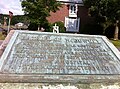 Battle of McDowell plaque.jpg 797 × 591; 122 KB
-
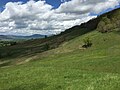
 Blue Grass Valley 1.jpg 4 896 × 3 264; 8,58 MB
-
 Blue Grass Valley 2.jpg 4 896 × 2 914; 9,86 MB
-
 Blue Grass Valley 3.jpg 4 896 × 3 264; 10,52 MB
-
 Blue Grass Valley 4.jpg 4 896 × 3 264; 9,83 MB
-
 Blue Grass Valley 5.jpg 4 896 × 3 264; 9,39 MB
-
 Blue Grass Valley 6.jpg 4 896 × 3 264; 8,65 MB
-
 Blue Grass, VA, USA - panoramio.jpg 9 695 × 5 179; 9,48 MB
-
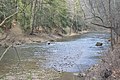 Bullpasture River above Williamsville.jpg 6 016 × 4 000; 6,49 MB
-
 Clover Creek, Virginia National Map.jpg 1 454 × 1 136; 970 KB
-
 Cows Blue Grass, Virginia.jpg 3 456 × 2 304; 4,25 MB
-
 Devils Backbone (Highland County, Virginia).jpg 1 600 × 1 067; 512 KB
-
 Doe Hill, Virginia National Map.jpg 998 × 972; 700 KB
-
 Hardscrabble VA National Map.JPG 657 × 624; 395 KB
-
 Highland County Area 422 Square Miles historical marker.jpg 6 016 × 4 000; 7,07 MB
-
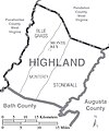 Highland County Virginia Census Map.jpg 1 173 × 1 407; 406 KB
-
 HighlandCounty.wmg.jpg 1 200 × 691; 104 KB
-
 Laurel Fork, Highland County, Virginia USGS.jpg 1 364 × 706; 1,21 MB
-
 McDowell cemetery plaque.JPG 1 017 × 605; 192 KB
-
 New Hampden, Virginia National Map.jpg 942 × 888; 623 KB
-
 Possum Trot, Virginia National Map.jpg 1 390 × 1 086; 1,1 MB
-
 USA Highland County, Virginia age pyramid.svg 520 × 600; 7 KB
_on_the_northwestern_slopes_of_Monterey_Mountain_in_Highland_County,_Virginia.jpg)
_on_the_northwestern_slopes_of_Monterey_Mountain_in_Highland_County,_Virginia.jpg)
_on_the_northwestern_slopes_of_Monterey_Mountain_in_Highland_County,_Virginia.jpg)
_on_the_northwestern_slopes_of_Monterey_Mountain_in_Highland_County,_Virginia.jpg)
_in_northwestern_Highland_County,_Virginia.jpg)
_in_northwestern_Highland_County,_Virginia.jpg)
_in_northwestern_Highland_County,_Virginia.jpg)
_in_northwestern_Highland_County,_Virginia.jpg)
_in_northwestern_Highland_County,_Virginia.jpg)
_in_northwestern_Highland_County,_Virginia.jpg)
_on_the_northwestern_slopes_of_Monterey_Mountain_in_Highland_County,_Virginia.jpg)
_on_the_northwestern_slopes_of_Monterey_Mountain_in_Highland_County,_Virginia.jpg)
_on_the_northwestern_slopes_of_Monterey_Mountain_in_Highland_County,_Virginia.jpg)
_on_the_northwestern_slopes_of_Monterey_Mountain_in_Highland_County,_Virginia.jpg)
_on_the_northwestern_slopes_of_Monterey_Mountain_in_Highland_County,_Virginia.jpg)
_in_Highland_County,_Virginia.jpg)
_in_Highland_County,_Virginia.jpg)
_in_Highland_County,_Virginia.jpg)
_in_Highland_County,_Virginia.jpg)
_in_Highland_County,_Virginia.jpg)
_in_Highland_County,_Virginia.jpg)
_in_Highland_County,_Virginia.jpg)
_in_Highland_County,_Virginia.jpg)


.jpg)


_on_the_northwestern_slopes_of_Monterey_Mountain_in_Highland_County,_Virginia.jpg)
_in_northwestern_Highland_County,_Virginia.jpg)
_in_Highland_County,_Virginia.jpg)