Category:History of Chiba prefecture
Zur Navigation springen
Zur Suche springen

English: History of Chiba prefecture
日本語: 千葉県の歴史
| Medium hochladen | |||||
| Ist ein(e) |
| ||||
|---|---|---|---|---|---|
| Aspekt von | |||||
| Ort |
| ||||
| |||||
Unterkategorien
Es werden 41 von insgesamt 41 Unterkategorien in dieser Kategorie angezeigt:
In Klammern die Anzahl der enthaltenen Kategorien (K), Seiten (S), Dateien (D)
*
- History of Kamogawa, Chiba (42 D)
- History of Kyonan, Chiba (6 D)
- History of Minamiboso, Chiba (35 D)
A
C
- Chiba Tank School (2 D)
E
I
J
K
- Koganemaki (11 D)
M
N
- NDL-DC 980721 Chiba-ken Awa-gun Shi (780 D)
O
- Oyumi Domain (1 D)
P
S
- Seiso Electric Railroad (8 D)
T
Medien in der Kategorie „History of Chiba prefecture“
Folgende 36 Dateien sind in dieser Kategorie, von 36 insgesamt.
-
 Camp Tomlinson Water Tower 1954.png 2.697 × 2.011; 510 KB
-
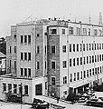
 Chiba District Office.JPG 553 × 356; 55 KB
-
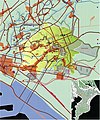
 Chiba map circa 1930.PNG 1.104 × 1.768; 1,2 MB
-
 Chiba Prefectural Police Department Building.JPG 288 × 302; 26 KB
-
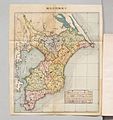 ChibakenYouranMap 1925.jpg 4.753 × 5.065; 2,62 MB
-
 Creeks and small boats in the Jurokushima area. Circa 1930 postcard.jpg 1.643 × 1.029; 586 KB
-
 Former yoshida house - full - june 24 2016.jpg 4.320 × 3.240; 2,99 MB
-
 Fukushima I Accidents Chiba Iod-131 tap water contamination.png 930 × 620; 138 KB
-
 Gasoline railcar used in Isumi kido.jpg 390 × 290; 18 KB
-
 Hotta residence1.jpg 1.280 × 960; 183 KB
-
 Katori-nahiko-house,katori-city,japan.JPG 1.600 × 1.200; 738 KB
-
 Matumoto-koshiroⅠgrave,katori-city,japan.JPG 1.600 × 1.200; 809 KB
-
 Route map of Isumi Tramway.png 870 × 314; 50 KB
-
 Route map of Tokatsu Jinsha Railway.png 615 × 515; 57 KB
-
 Ruins of Fujikokoro Jin'ya.JPG 2.560 × 1.920; 2,79 MB
-
 Satou-takanaka-birthplace,katori-city,japan.JPG 1.600 × 1.200; 805 KB
-
 Shimofusa Imperial Stock Farm.JPG 566 × 304; 41 KB
-
 Site sketch of Ichikawa family murder of four people.svg 512 × 683; 37 KB
-
 Solar eclipse chiba japan 2012may20 2233utc.jpg 1.024 × 768; 313 KB
-
 Solar eclipse chiba japan 2012may20 2238utc.jpg 1.306 × 980; 513 KB
-
 Solar eclipse chiba japan 2012may20 2244utc.jpg 1.536 × 1.068; 657 KB
-
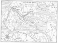 Suigo map circa 1930.PNG 1.397 × 1.032; 925 KB
-
 Teganuma Disneyland Plan 3.png 689 × 493; 206 KB
-
 Tone Canal Monument.JPG 1.536 × 2.048; 2,04 MB
-
 二宮町域図.jpg 3.362 × 4.049; 10,9 MB
-
 千葉県千葉郡二宮村役場.jpg 1.573 × 1.175; 2,15 MB
-
 木内廃寺跡 出土品.JPG 3.241 × 2.011; 2,23 MB
-
 東葛人車鉄道.JPG 4.000 × 3.000; 2,24 MB
-
 東間部多1号墳出土 横矧板鋲留短甲.JPG 3.835 × 3.331; 4,61 MB
-
 猫作・栗山16号墳 中央石枕出土品.JPG 5.252 × 3.260; 5,83 MB
-
 猫作・栗山16号墳 北側石枕出土品.JPG 5.180 × 3.276; 5,32 MB
-
 祇園大塚山古墳 出土品.JPG 4.962 × 3.273; 6,62 MB
-
 祇園大塚山古墳出土 金銅製眉庇付冑 (J-728).JPG 4.009 × 3.185; 4,77 MB
-
 葛飾県印旛県庁跡碑 正面.JPG 3.072 × 2.304; 1.005 KB
-
 葛飾県印旛県庁跡碑.JPG 3.008 × 2.000; 2,85 MB
-
 高瀬舟.jpg 400 × 279; 19 KB


.JPG)


