Category:Horní Heřmanice (Třebíč District)
Salta a la navigazzion
Và a cercà
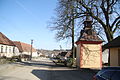
comune ceco della regione di Vysočina  Centrum obce s kaplí Panny Marie   | |||||
| Carega su un fail audio / video | |||||
| L'è un(a) | |||||
|---|---|---|---|---|---|
| Sit | |||||
| Popolazzion |
| ||||
| Area |
| ||||
| Altezza in sul mar |
| ||||
| sit ofizzial | |||||
 | |||||
Sotocategorie
Quella categoria chì la gh'ha 7 sot-categorie chì de sota, su un numer complessiv de 7.
B
D
S
Fail in la categoria "Horní Heřmanice (Třebíč District)"
Quella categoria chì la gh'ha denter 2 i fail riportad chì de sota, su un total de 2.
-
 Center of Horní Heřmanice in 2015, Třebíč District.JPG 3 888 × 2 592; 4,74 MByte
-
 Center with chapel of Saint Mary in Horní Heřmanice, Třebíč District.JPG 4 320 × 3 240; 3,89 MByte
