Category:Hurricane, Utah
Vai alla navigazione
Vai alla ricerca
comune statunitense dello Utah   | |||||
| Carica un file multimediale | |||||
| Istanza di | |||||
|---|---|---|---|---|---|
| Luogo | contea di Washington, Utah, Stati Uniti d'America | ||||
| Situato sul mare / lago / fiume | |||||
| Data di fondazione o creazione |
| ||||
| Popolazione |
| ||||
| Superficie |
| ||||
| Altezza sul mare |
| ||||
| sito web ufficiale | |||||
 | |||||
English: Media related to Hurricane, Utah, a city along the Virgin River in south-central Washington County, Utah, United States.
Sottocategorie
Questa categoria contiene le 10 sottocategorie indicate di seguito, su un totale di 10.
B
G
- Gould Wash Bridge (14 F)
H
- Harrisburg, Utah (4 F)
- Hurricane Canal (25 F)
Q
- Quail Creek State Park (2 F)
S
V
File nella categoria "Hurricane, Utah"
Questa categoria contiene 50 file, indicati di seguito, su un totale di 50.
-
 2010-08-04 07.38.42 - panoramio.jpg 2 592 × 1 936; 956 KB
-
 CtyMapWashington.png 936 × 689; 35 KB
-
 Desert Great Horned Owl.jpg 3 136 × 1 745; 1,66 MB
-
 Desert great horned owl.jpg 3 325 × 1 424; 1,47 MB
-
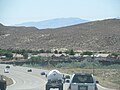
 East at SR-9 & SR-59, Hurricane, Utah, Oct 16.jpg 2 592 × 1 944; 2,4 MB
-
 END UT-9, JCT I-15, 1-2 Mile - panoramio.jpg 1 600 × 1 200; 386 KB
-
 Error BL-15 Shield at UT-59-UT-9 Junction - panoramio.jpg 1 600 × 1 200; 424 KB
-
 Fenestrate Bryozoan - panoramio.jpg 3 264 × 1 840; 1,25 MB
-
 Fire hydrant in Hurricane, Utah, Oct 16.jpg 2 592 × 1 944; 2,33 MB
-
 Hurricane - panoramio - photophat (1).jpg 2 800 × 2 128; 1,39 MB
-
 Hurricane - panoramio - photophat (2).jpg 2 800 × 2 128; 1,35 MB
-
 Hurricane - panoramio - photophat.jpg 2 797 × 1 416; 1,92 MB
-
 Hurricane banner.jpg 2 816 × 402; 262 KB
-
 Hurricane hillside letter (38551916586).jpg 2 974 × 1 802; 1,76 MB
-
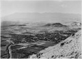
 Hurricane Valley from Molly's Nipple - panoramio.jpg 5 824 × 1 072; 3,28 MB
-
 Hurricaneutah.jpg 2 816 × 2 120; 1,44 MB
-
 HurricaneUtah1929.gif 600 × 429; 88 KB
-
 Letter boxes in Hurricane, Utah, Oct 16.jpg 1 944 × 2 592; 1,66 MB
-
 Looking Towards Zion - panoramio.jpg 2 800 × 2 128; 1,44 MB
-
 North at SR-9 & SR-59, Hurricane, Utah, Oct 16.jpg 2 592 × 1 944; 2,43 MB
-
 Pentamerid brachiopod and crinoid stem - panoramio.jpg 1 840 × 3 264; 1,48 MB
-
 Permian Kaibab formation with tons of fossils. - panoramio.jpg 3 264 × 1 840; 1,97 MB
-
 Rim Trail in Hurricane, Utah - panoramio.jpg 4 608 × 3 456; 3,26 MB
-
 South at SR-9 & SR-59, Hurricane, Utah, Oct 16.jpg 2 592 × 1 944; 2,41 MB
-
 State Street and Main Street, Hurricane, Utah.jpg 922 × 659; 480 KB
-
 Sunrise over Hurricane, Utah.jpg 1 280 × 960; 834 KB
-
 UT-9 WB at UT-318 - panoramio.jpg 1 600 × 1 200; 666 KB
-
 Utah State Highway 9 - 9078948411.jpg 3 072 × 2 304; 431 KB
-
 Utah State Highway 9 - 9078949915.jpg 3 072 × 2 304; 847 KB
-
 Utah State Highway 9 - 9078950485.jpg 3 072 × 2 304; 565 KB
-
 Utah State Highway 9 - 9078951405.jpg 3 072 × 2 304; 438 KB
-
 Utah State Highway 9 - 9078951797.jpg 3 072 × 2 304; 404 KB
-
 Utah State Highway 9 - 9078952543.jpg 3 072 × 2 304; 792 KB
-
 Utah State Highway 9 - 9078954123.jpg 3 072 × 2 304; 716 KB
-
 Utah State Highway 9 - 9078955111.jpg 3 072 × 2 304; 790 KB
-
 Utah State Highway 9 - 9078956533.jpg 3 072 × 2 304; 597 KB
-
 Utah State Highway 9 - 9081174490.jpg 3 072 × 2 304; 635 KB
-
 Utah State Highway 9 - 9081176320.jpg 3 072 × 2 304; 498 KB
-
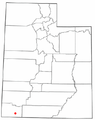 UTMap-doton-Hurricane.PNG 238 × 300; 18 KB
-
 View of Hurricane, UT and Zions from Molly's Nipple - panoramio.jpg 5 920 × 1 072; 3,94 MB
-

-
-

-
 Virgin River at Confluence Park - panoramio.jpg 3 264 × 1 840; 1,35 MB
-
 Virgin River at Confluence Park, Basaltic Flows are aged 0.14 - 0.06 Ma - panoramio.jpg 3 264 × 1 840; 1,54 MB
-
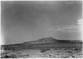 Volcanic cone two miles west of Hurricane, Utah. - NARA - 520475.jpg 3 000 × 2 145; 1,43 MB
-
 Volcanic cone two miles west of Hurricane, Utah. - NARA - 520475.tif 3 000 × 2 145; 6,14 MB
-

-
 Washingtoncounty ut.png 980 × 663; 35 KB
-
 West at SR-9 & SR-59, Hurricane, Utah, Oct 16.jpg 2 592 × 1 944; 2,32 MB


.jpg)
.jpg)

.jpg)


.jpg)


Categorie:
- Cities in Utah
- Populated places in Washington County, Utah
- Locations along Utah State Route 7
- Locations along Utah State Route 9 in Washington County, Utah
- Locations along Utah State Route 15 (1912-1977) in Washington County, Utah
- Locations along Utah State Route 17 (1912-1969)
- Locations along Utah State Route 59