Category:Hutton Buscel
Aller à la navigation
Aller à la recherche
localité britannique du comté anglais de North Yorkshire  | |||||
| Téléverser des médias | |||||
| Nature de l’élément | |||||
|---|---|---|---|---|---|
| Lieu | Scarborough (district), Yorkshire du Nord, Yorkshire-et-Humber, Angleterre | ||||
 | |||||
Sous-catégories
Cette catégorie comprend 2 sous-catégories, dont les 2 ci-dessous.
H
- Hutton Buscel War Memorial (1 F)
S
Média dans la catégorie « Hutton Buscel »
Cette catégorie comprend 159 fichiers, dont les 159 ci-dessous.
-
 A footpath to Revenge Wood on the Dawnay Estate - geograph.org.uk - 2498927.jpg 800 × 600 ; 295 kio
-
 A170 lay-by at Hutton Buscel - geograph.org.uk - 4732129.jpg 640 × 481 ; 39 kio
-
 A170 near Hutton Buscel - geograph.org.uk - 5319652.jpg 4 576 × 2 944 ; 3,48 Mio
-
 All these tracks look the same, have faith in the leader^ - geograph.org.uk - 4184863.jpg 4 608 × 3 456 ; 6,43 Mio
-
 Approaching jump 7 - geograph.org.uk - 416117.jpg 640 × 479 ; 108 kio
-
 Beedale - geograph.org.uk - 1040530.jpg 640 × 480 ; 69 kio
-
 Bridleway in Wykeham Forest - geograph.org.uk - 4934947.jpg 960 × 717 ; 248 kio
-
 Bridleway towards Wykeham Lane - geograph.org.uk - 5364652.jpg 1 600 × 1 200 ; 654 kio
-
 Carr Hill - geograph.org.uk - 4424164.jpg 1 024 × 683 ; 267 kio
-
 Carr Hill - geograph.org.uk - 6325178.jpg 2 048 × 1 536 ; 794 kio
-
 Charm Park - geograph.org.uk - 4398402.jpg 2 504 × 1 789 ; 785 kio
-
 Charm Park point to point - geograph.org.uk - 416111.jpg 640 × 479 ; 101 kio
-
 Clearing in Wykeham Forest - geograph.org.uk - 1502421.jpg 640 × 480 ; 97 kio
-
 Confluence of drains - geograph.org.uk - 4398339.jpg 640 × 457 ; 103 kio
-

-
 Do not climb on timber stacks - geograph.org.uk - 1033174.jpg 640 × 480 ; 127 kio
-
 Entrance to Long Causeway Plantation - geograph.org.uk - 4398369.jpg 2 629 × 1 878 ; 855 kio
-
 Entrance to Wykeham Quarries - geograph.org.uk - 4398377.jpg 2 507 × 1 791 ; 662 kio
-
 Far Lane - geograph.org.uk - 6325186.jpg 2 048 × 1 536 ; 776 kio
-
 Far Lane to Hutton Bescel - geograph.org.uk - 1502443.jpg 640 × 480 ; 85 kio
-
 Far Lane to Hutton Bescel - geograph.org.uk - 1502449.jpg 640 × 480 ; 89 kio
-
 Farm Building, Far Lane - geograph.org.uk - 1502447.jpg 640 × 480 ; 60 kio
-
 Farm Building, Great Moor Road - geograph.org.uk - 1502431.jpg 640 × 480 ; 85 kio
-
 Fenton's Balk - geograph.org.uk - 6325181.jpg 2 048 × 1 536 ; 1,03 Mio
-
 Field margin north of Hutton Buscel - geograph.org.uk - 249476.jpg 640 × 480 ; 120 kio
-
 Fishing lake, Wykeham - geograph.org.uk - 4424148.jpg 1 024 × 683 ; 444 kio
-
 Forest Road - geograph.org.uk - 1502415.jpg 640 × 480 ; 90 kio
-
 Forest Track - geograph.org.uk - 1502419.jpg 640 × 480 ; 109 kio
-
 Forest Track - geograph.org.uk - 1502424.jpg 640 × 480 ; 105 kio
-
 Forest track - geograph.org.uk - 4357150.jpg 683 × 1 024 ; 307 kio
-
 Forest Track at Coomb Hill - geograph.org.uk - 3116914.jpg 427 × 640 ; 281 kio
-
 Forestry road, Wykeham Forest - geograph.org.uk - 4357121.jpg 1 024 × 683 ; 304 kio
-
 Forestry road, Wykeham Forest - geograph.org.uk - 4357246.jpg 1 024 × 683 ; 370 kio
-
 Fothill Lane joins the A170 at Hutton Buscel - geograph.org.uk - 2498934.jpg 800 × 600 ; 219 kio
-
 Gravel extraction - geograph.org.uk - 3676619.jpg 1 024 × 768 ; 447 kio
-
 Gravel extraction by dragline at Wykeham Quarry - geograph.org.uk - 3760918.jpg 2 592 × 1 944 ; 2,11 Mio
-
 Great Moor Road - geograph.org.uk - 1502427.jpg 640 × 480 ; 94 kio
-
 Great Moor Road - geograph.org.uk - 1502432.jpg 640 × 480 ; 94 kio
-
 Great Moor Road - geograph.org.uk - 3466975.jpg 1 600 × 1 200 ; 825 kio
-
 Great Moor Road - geograph.org.uk - 4934951.jpg 960 × 717 ; 180 kio
-
 Great Moor Road - geograph.org.uk - 6325196.jpg 2 048 × 1 536 ; 1,44 Mio
-
 Great Moor Road 2 - geograph.org.uk - 4934956.jpg 960 × 717 ; 102 kio
-
 Great Moor Road in Wykeham Forest - geograph.org.uk - 4184836.jpg 4 608 × 3 456 ; 5,53 Mio
-
 Great Moor Road into Hutton Buscel - geograph.org.uk - 4183955.jpg 4 608 × 3 456 ; 3,76 Mio
-
 Great Moor Road to Hutton Bescel - geograph.org.uk - 1502437.jpg 640 × 480 ; 79 kio
-
 Horse chestnut, Hutton Buscel - geograph.org.uk - 4398450.jpg 1 822 × 2 550 ; 901 kio
-
 Horse on jump 7 - geograph.org.uk - 416319.jpg 640 × 498 ; 124 kio
-
 House at Ings Bridge - geograph.org.uk - 3462723.jpg 4 000 × 3 000 ; 3,22 Mio
-
 House by the Church - geograph.org.uk - 3676549.jpg 1 024 × 768 ; 781 kio
-
 Houses dated 1933, Hutton Buscel - geograph.org.uk - 246103.jpg 640 × 510 ; 101 kio
-
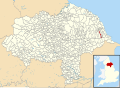 Hutton Bascel UK parish locator map.svg 1 425 × 1 037 ; 4,3 Mio
-
 Hutton Buscel - geograph.org.uk - 1031710.jpg 640 × 480 ; 86 kio
-
 Hutton Buscel - geograph.org.uk - 1039459.jpg 480 × 640 ; 47 kio
-
 Hutton Buscel - geograph.org.uk - 1334969.jpg 640 × 427 ; 74 kio
-
 Hutton Buscel - geograph.org.uk - 3530728.jpg 3 676 × 2 558 ; 3,44 Mio
-
 Hutton Buscel Carr - geograph.org.uk - 5954682.jpg 2 048 × 1 536 ; 792 kio
-
 Hutton Buscel drone1.jpg 1 333 × 1 000 ; 182 kio
-
 Hutton Buscel Pinfold - geograph.org.uk - 1031736.jpg 480 × 640 ; 143 kio
-
 Hutton Buscel Pinfold on Great Moor Road - geograph.org.uk - 4183947.jpg 4 608 × 3 456 ; 4,15 Mio
-
 Hutton Buscel School - geograph.org.uk - 1193171.jpg 640 × 480 ; 61 kio
-
 Hutton Buscel Standing Stone - geograph.org.uk - 1192700.jpg 480 × 640 ; 109 kio
-
 Hutton Buscel, North Yorkshire - geograph.org.uk - 2498923.jpg 800 × 600 ; 246 kio
-
 Hutton Buscel, Yorkshire, England (27716575530).jpg 5 616 × 3 744 ; 18,03 Mio
-
 Hutton Buscel, Yorkshire, England (28237825592).jpg 5 616 × 3 744 ; 15,87 Mio
-
 Hutton Buscel, Yorkshire, England (28539688135).jpg 2 522 × 5 132 ; 6,04 Mio
-
 Hutton Buscel, Yorkshire, England (28821829104).jpg 5 403 × 3 009 ; 8,89 Mio
-
 Hutton Buscel, Yorkshire, England (28894826894).jpg 5 616 × 3 744 ; 15,87 Mio
-
 Hutton Buscel, Yorkshire, England (29931094433).jpg 5 616 × 3 744 ; 11,83 Mio
-
 Hutton Cross Road - geograph.org.uk - 1033153.jpg 640 × 480 ; 90 kio
-
 In Wykeham Forest - geograph.org.uk - 6173328.jpg 2 048 × 1 536 ; 1,48 Mio
-
 Ings Bridge - geograph.org.uk - 1501739.jpg 640 × 480 ; 63 kio
-
 Ings Bridge - geograph.org.uk - 4398321.jpg 2 559 × 1 828 ; 827 kio
-
 Ings Lane - geograph.org.uk - 3676631.jpg 1 024 × 768 ; 520 kio
-
 Ings Lane toward Ings Bridge - geograph.org.uk - 3462717.jpg 4 000 × 3 000 ; 3,17 Mio
-
 Jump 7 - geograph.org.uk - 416121.jpg 640 × 479 ; 109 kio
-
 Junction of Fothill Lane and the A170 - geograph.org.uk - 3525506.jpg 3 675 × 2 575 ; 2,75 Mio
-
 Lang Gate - geograph.org.uk - 3116912.jpg 427 × 640 ; 244 kio
-
 Layby at Hutton Buscel - geograph.org.uk - 3932124.jpg 1 600 × 1 029 ; 466 kio
-
 Leaving Hutton Buscel - geograph.org.uk - 5881617.jpg 1 024 × 683 ; 109 kio
-
 Logging in Wykeham Forest - geograph.org.uk - 1226569.jpg 640 × 429 ; 127 kio
-
 Long Causeway Road - geograph.org.uk - 1501779.jpg 640 × 480 ; 98 kio
-
 Long Causeway Road - geograph.org.uk - 1501796.jpg 640 × 480 ; 74 kio
-
 Long Causeway Road - geograph.org.uk - 1501822.jpg 640 × 480 ; 69 kio
-
 Looking over the garden wall - geograph.org.uk - 2013447.jpg 800 × 600 ; 320 kio
-
 Low Carr Drain - geograph.org.uk - 1501746.jpg 640 × 480 ; 112 kio
-
 Lower Causeway Plantation - geograph.org.uk - 1501784.jpg 640 × 480 ; 93 kio
-
 Lych Gate, Hutton Buscel - geograph.org.uk - 1501898.jpg 640 × 480 ; 77 kio
-
 Main street , Hutton Buscel - geograph.org.uk - 3530732.jpg 2 476 × 1 803 ; 1,41 Mio
-
 Manor House Hutton Buscel - geograph.org.uk - 4183930.jpg 4 608 × 3 456 ; 4,35 Mio
-
 Manorial Pinfold Hutton Buscel - geograph.org.uk - 1031741.jpg 640 × 360 ; 77 kio
-
 Middle Lane - geograph.org.uk - 5756999.jpg 2 048 × 1 536 ; 1,24 Mio
-
 Minor road to the A170 - geograph.org.uk - 4424166.jpg 1 024 × 683 ; 314 kio
-
 Minor Road Towards Hutton Buscel - geograph.org.uk - 1501870.jpg 640 × 480 ; 68 kio
-
 Moor Dyke, Wykeham Forest - geograph.org.uk - 4723950.jpg 3 264 × 2 448 ; 2,91 Mio
-
 Mount Pleasant Farm, Hutton Buscel - geograph.org.uk - 2498918.jpg 800 × 600 ; 241 kio
-
 Muddy footpath, Wykeham Forest - geograph.org.uk - 4357135.jpg 1 024 × 683 ; 374 kio
-
 Near Wykeham Quarries - geograph.org.uk - 4424159.jpg 1 024 × 683 ; 325 kio
-
 New Ings Plantation - geograph.org.uk - 1501763.jpg 640 × 480 ; 131 kio
-
 Nice pair of houses - geograph.org.uk - 2013457.jpg 800 × 600 ; 268 kio
-
 Old railway embankment - geograph.org.uk - 4398408.jpg 2 625 × 1 875 ; 794 kio
-
 Parkland and sheep tracks NW of Hutton Buscel - geograph.org.uk - 5881612.jpg 1 024 × 649 ; 68 kio
-
 Part of the point to point course near Wykeham - geograph.org.uk - 5364661.jpg 1 600 × 1 200 ; 466 kio
-
 Path to Mount Misery - geograph.org.uk - 5757001.jpg 2 048 × 1 536 ; 1,7 Mio
-
 Pheasant Lodge - geograph.org.uk - 1501836.jpg 640 × 480 ; 112 kio
-
 Pinfold gate - geograph.org.uk - 1031737.jpg 427 × 640 ; 99 kio
-
 Pivot bench mark near Hutton Buscel church - geograph.org.uk - 2494098.jpg 480 × 640 ; 154 kio
-
 Post-harvest cultivation - geograph.org.uk - 3676627.jpg 1 024 × 768 ; 465 kio
-
 Preston Ings - geograph.org.uk - 4398304.jpg 2 619 × 1 871 ; 963 kio
-
 Rail Bridge from A170 near Hutton Buscel - geograph.org.uk - 759028.jpg 640 × 427 ; 84 kio
-
 Recently cleared bridleway near Hutton Buscel - geograph.org.uk - 3062701.jpg 768 × 1 024 ; 247 kio
-
 Relocated gravestones - geograph.org.uk - 3676541.jpg 1 024 × 768 ; 761 kio
-
 Restored stone stile near Hutton Buscel church - geograph.org.uk - 2494110.jpg 480 × 640 ; 234 kio
-
 Road through Wykeham Forest - geograph.org.uk - 1502412.jpg 640 × 480 ; 94 kio
-
 Road to Hutton Buscel - geograph.org.uk - 5881501.jpg 800 × 533 ; 106 kio
-
 Sand and Gravel Works - geograph.org.uk - 1501843.jpg 640 × 480 ; 40 kio
-
 Shed made of old railway sleepers - geograph.org.uk - 4398332.jpg 2 545 × 1 818 ; 937 kio
-
 Southern edge of Danby's Riggs Plantation - geograph.org.uk - 3462734.jpg 4 000 × 3 000 ; 2,7 Mio
-
 St Matthew's Church, Hutton Buscel - geograph.org.uk - 5364657.jpg 1 600 × 1 200 ; 715 kio
-
 Statuette in niche at St Matthews - geograph.org.uk - 3676533.jpg 768 × 1 024 ; 746 kio
-
 Steep hill down to Wrench Green - geograph.org.uk - 4357259.jpg 1 024 × 683 ; 318 kio
-
 Stile at Ings Farm - geograph.org.uk - 3308909.jpg 2 387 × 1 946 ; 5,68 Mio
-
 Stopping for refreshments - geograph.org.uk - 3932129.jpg 800 × 525 ; 85 kio
-
 Straits Lane - geograph.org.uk - 4398313.jpg 2 469 × 1 764 ; 843 kio
-
 Swanhills Lane - geograph.org.uk - 4398349.jpg 2 654 × 1 896 ; 921 kio
-
 Tetherings Lane - geograph.org.uk - 1501828.jpg 640 × 480 ; 88 kio
-
 Tetherings Lane - geograph.org.uk - 6325175.jpg 2 048 × 1 536 ; 1 010 kio
-
 The attractive village of Hutton Buscel.jpg 640 × 480 ; 102 kio
-
 The Granary at Hutton Buscel - geograph.org.uk - 1192704.jpg 640 × 480 ; 99 kio
-
 The Manor House, Hutton Buscel - geograph.org.uk - 246075.jpg 640 × 480 ; 89 kio
-
 The old shed (28560927435).jpg 5 616 × 3 744 ; 12,95 Mio
-
 The Vicarage, Hutton Buscel - geograph.org.uk - 246022.jpg 640 × 441 ; 76 kio
-
 To West Ayton Moor - geograph.org.uk - 4357158.jpg 1 024 × 683 ; 318 kio
-
 Track above Mount Misery - geograph.org.uk - 3116901.jpg 427 × 640 ; 298 kio
-
 Track Beside New Ings Plantation - geograph.org.uk - 1501758.jpg 640 × 480 ; 127 kio
-
 Track into Causeway Plantations - geograph.org.uk - 5364765.jpg 1 600 × 1 200 ; 1,01 Mio
-
 Track to Charm Park - geograph.org.uk - 1501857.jpg 640 × 480 ; 78 kio
-

-
 Unsuitable for motor vehicles - geograph.org.uk - 1033148.jpg 480 × 640 ; 93 kio
-
 Waymarks on Tabular Hills Walk... - geograph.org.uk - 4357143.jpg 3 208 × 3 208 ; 1,11 Mio
-
 White clematis (27625020594).jpg 5 616 × 3 364 ; 8,08 Mio
-
 Woodland adjacent to Moor Closes - geograph.org.uk - 1502429.jpg 640 × 480 ; 109 kio
-
 Wykeham Forest - geograph.org.uk - 1502417.jpg 640 × 480 ; 136 kio
-
 Wykeham Forest - geograph.org.uk - 5757004.jpg 2 048 × 1 536 ; 1,92 Mio
-
 Yedmandale Woods - geograph.org.uk - 1502441.jpg 640 × 480 ; 73 kio
-
 Along Great Moor Road - geograph.org.uk - 1031746.jpg 640 × 360 ; 86 kio
-
 Automated watering of young trees - geograph.org.uk - 206202.jpg 640 × 480 ; 95 kio
-
 Bridleway beside Cockmoor Plantation - geograph.org.uk - 1502401.jpg 640 × 480 ; 73 kio
-

-
 Estate gatehouse at the entrance to Wykeham Lakes - geograph.org.uk - 206178.jpg 640 × 480 ; 145 kio
-
 Footpath Junction Wykeham Forest - geograph.org.uk - 1428691.jpg 640 × 480 ; 147 kio
-

-
 Former school, Hutton Buscel - geograph.org.uk - 245498.jpg 640 × 463 ; 65 kio
-
 Main house at High Yedmandale - geograph.org.uk - 422905.jpg 640 × 480 ; 134 kio
-
 Newly planted extension to Wykeham Forest - geograph.org.uk - 422903.jpg 640 × 480 ; 124 kio
-
 Old road sign, Hutton Buscel - geograph.org.uk - 246107.jpg 640 × 450 ; 78 kio
-
 One of many tracks in Wykeham Forest - geograph.org.uk - 422900.jpg 640 × 480 ; 102 kio
-

-
 Track running along Moor Dike - geograph.org.uk - 400528.jpg 640 × 480 ; 126 kio
-
 View across Charm Park to Staxton Wold - geograph.org.uk - 190595.jpg 640 × 480 ; 81 kio


.jpg)
.jpg)
.jpg)
.jpg)
.jpg)
.jpg)


.jpg)


.jpg)


