Category:Irby in the Marsh
Aller à la navigation
Aller à la recherche
English: Irby in the Marsh is a settlement approximately 5 miles North of Wainfleet with a population of 135 inhabitants. It lies on the B1195 East of Spilsby. It has a small parish church seating approximately 95 people and a village hall located off Brambleberry lane towards the Bratoft boundary. The B1195 has a notoriously sharp bends to the West of the Village where cars frequently have to be pulled out of a ditch. (known to locals as Dunks Ditch). Heading south towards Wainfleet on the edge of the village is the old Prince Albert public house, now called the Denbies. Opposite this position just before the B1195 intersects Lymn bank East and West lies the Oliver deep dyke another well known area for vehicle accidents lying several hundred meters up of Dunks Ditch.
localité britannique du comté anglais de Lincolnshire  | |||||
| Téléverser des médias | |||||
| Nature de l’élément | |||||
|---|---|---|---|---|---|
| Lieu | East Lindsey, Lincolnshire, Midlands de l'Est, Angleterre | ||||
 | |||||
Sous-catégories
Cette catégorie comprend 2 sous-catégories, dont les 2 ci-dessous.
Média dans la catégorie « Irby in the Marsh »
Cette catégorie comprend 43 fichiers, dont les 43 ci-dessous.
-
 Approaching Irby in the Marsh on the B1195 - geograph.org.uk - 2713432.jpg 1 280 × 960 ; 706 kio
-
 B1195 east of Great Steeping, aerial 2018 - geograph.org.uk - 5661776.jpg 800 × 533 ; 75 kio
-
 Bend in Brambleberry Lane - geograph.org.uk - 3799150.jpg 3 088 × 2 056 ; 4,8 Mio
-
 Brambleberry Lane, Bratoft - geograph.org.uk - 5297522.jpg 640 × 427 ; 88 kio
-
 Chapel Lane junction at Irby in the Marsh - geograph.org.uk - 3528154.jpg 640 × 354 ; 77 kio
-

-
 Crop field off Mill Lane - geograph.org.uk - 3491468.jpg 640 × 480 ; 79 kio
-
 Drain clearance - geograph.org.uk - 2105557.jpg 640 × 427 ; 91 kio
-
 Entering Irby in the Marsh - geograph.org.uk - 3879733.jpg 640 × 480 ; 57 kio
-
 Farmland and hedgerow - geograph.org.uk - 3879729.jpg 640 × 480 ; 75 kio
-
 Farmland, Irby in the Marsh - geograph.org.uk - 3879738.jpg 640 × 480 ; 78 kio
-
 Field with distant sheep - geograph.org.uk - 2711921.jpg 1 280 × 960 ; 221 kio
-

-
-

-
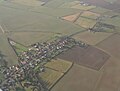
 From Irby in the Marsh to Lymn Bank, aerial 2018 - geograph.org.uk - 5660595.jpg 1 024 × 596 ; 90 kio
-
 Grazing, Irby in the Marsh - geograph.org.uk - 3879743.jpg 640 × 480 ; 59 kio
-

-
 Irby in the Marsh, aerial 2014 - geograph.org.uk - 4269870.jpg 640 × 400 ; 66 kio
-
 Irby in the Marsh, Pinfold Lane - pre WWI.jpg 1 053 × 603 ; 447 kio
-

-
 Lymn Bank - geograph.org.uk - 2105562.jpg 640 × 427 ; 94 kio
-
 Mill Lane heading south - geograph.org.uk - 3491471.jpg 640 × 480 ; 53 kio
-
 Phone box on bend in Irby In The Marsh - geograph.org.uk - 3528149.jpg 640 × 305 ; 79 kio
-
 Pinfold Lane meets Wainfleet Road - geograph.org.uk - 3795228.jpg 1 600 × 1 065 ; 372 kio
-
 Poplar Cottage on Wainfleet Road - geograph.org.uk - 4151027.jpg 1 600 × 1 150 ; 399 kio
-

-
 Rookery - geograph.org.uk - 266424.jpg 640 × 427 ; 69 kio
-
 Sweet street name - geograph.org.uk - 6309448.jpg 4 608 × 3 456 ; 5,41 Mio
-
 The former Irby Filling Station, Irby in the Marsh - geograph.org.uk - 4151022.jpg 1 600 × 1 200 ; 408 kio
-
 The Old Post Office, Irby in the Marsh - geograph.org.uk - 4151026.jpg 1 600 × 1 021 ; 387 kio
-
 Wainfleet Road (B1195), Irby in the Marsh - geograph.org.uk - 3879741.jpg 640 × 480 ; 55 kio
-
 Wainfleet Road (B1195), Irby in the Marsh - geograph.org.uk - 3879747.jpg 640 × 480 ; 78 kio
-
 Wainfleet Road from Lincoln Farm - geograph.org.uk - 3527813.jpg 640 × 418 ; 95 kio
-
 Wainfleet Road just north of Oxlands Lane - geograph.org.uk - 3527822.jpg 640 × 335 ; 37 kio
-

-
 Wainfleet Road, Irby in the Marsh - geograph.org.uk - 4151013.jpg 1 600 × 1 058 ; 480 kio
-
 Wesleyan Methodist Chapel, Irby in the Marsh - geograph.org.uk - 3879748.jpg 640 × 480 ; 67 kio
-
 Bridge No1 - geograph.org.uk - 421073.jpg 640 × 480 ; 76 kio
-
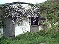 Clematis over stable - geograph.org.uk - 412557.jpg 640 × 480 ; 140 kio
-
 Copse after Dawn - geograph.org.uk - 423223.jpg 640 × 480 ; 77 kio
-
 Copse at dusk - geograph.org.uk - 363907.jpg 640 × 434 ; 49 kio
-
 Footpath, Irby in the Marsh - geograph.org.uk - 452378.jpg 640 × 480 ; 87 kio


,_aerial_2015_-_geograph.org.uk_-_4683753.jpg)


,_aerial_2018_-_geograph.org.uk_-_5661786.jpg)
_-_geograph.org.uk_-_5302558.jpg)


,_Irby_in_the_Marsh_-_geograph.org.uk_-_3879741.jpg)
,_Irby_in_the_Marsh_-_geograph.org.uk_-_3879747.jpg)


