Category:Isle of Lewis
Pereiti į navigaciją
Jump to search
English: The Isle of Lewis (Scottish Gaelic: Leòdhas, pronounced [ʎɔː.əs̪], is the northern part of Lewis and Harris, the largest island of the Western Isles or Outer Hebrides (an archipelago) of Scotland. The total area of Lewis is 683 square miles (1,770 km2)..

northern part of the Scottish island Lewis and Harris .JPG)  | |||||
| Įkelti mediją | |||||
| Tai yra | |||||
|---|---|---|---|---|---|
| Vieta | Išoriniai Hebridai, Škotija | ||||
| Gyventojų skaičius |
| ||||
| Plotas |
| ||||
 | |||||
Subkategorijos
Rodomos 25 subkategorijos (iš viso yra 25 subkategorijos).
- Nature of the Isle of Lewis (18 F)
A
- A858 road (Scotland) (34 F)
- A859 road (Scotland) (149 F)
- Arnish Point Lighthouse (22 F)
B
C
D
- Dun Bragar (6 F)
G
H
- Houses in the Isle of Lewis (7 F)
L
- Loch Barraglom (8 F)
M
N
P
- Photos by Caitriana Nicholson (24 F)
R
- RAF Aird Uig (10 F)
- Rubh Uisenis light (2 F)
S
- Signs on the Isle of Lewis (14 F)
- Steinacleit (32 F)
T
- Teampull Eoin, Isle of Lewis (2 F)
U
Daugialypės terpės rinkmenos kategorijoje „Isle of Lewis“
Rodoma 200 šios kategorijos rinkmenų (iš viso kategorijoje yra 1 008 rinkmenos).
(ankstesnis puslapis) (kitas puslapis)-
 "A Rugged Scot" - geograph.org.uk - 1613360.jpg 450 × 600; 40 KiB
-
 40 North - geograph.org.uk - 5900590.jpg 640 × 480; 292 KiB
-
 A burn called Runndagro - geograph.org.uk - 3469662.jpg 3 264 × 2 448; 5,03 MiB
-
 A burn flowing into Gleann Airigh an Domhnuill - geograph.org.uk - 1740178.jpg 3 000 × 4 000; 2,12 MiB
-
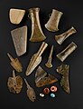 A collection of items from the Adabrock hoard, Isle of Lewis.jpg 692 × 900; 420 KiB
-
 A corner of Cunndal Bay - geograph.org.uk - 5897467.jpg 480 × 640; 278 KiB
-
 A moorland scene in winter - geograph.org.uk - 1725069.jpg 3 000 × 4 000; 5,97 MiB
-
 A858 - geograph.org.uk - 1252556.jpg 640 × 480; 111 KiB
-
 A858 at the eastern end of North Bragar - geograph.org.uk - 5900587.jpg 640 × 480; 296 KiB
-
 Abandoned building and phone box - geograph.org.uk - 5831721.jpg 1 600 × 900; 382 KiB
-
 Abandoned car, Airigh na Gaoithe, Isle of Lewis - geograph.org.uk - 5018716.jpg 1 459 × 1 067; 279 KiB
-
 Abandoned vehicles, Tom Meadhon Latha, Isle of Lewis - geograph.org.uk - 5445275.jpg 1 459 × 1 094; 338 KiB
-
 Abhainn a' Ghlinne Dhuibh - geograph.org.uk - 1248936.jpg 640 × 429; 95 KiB
-
 Abhainn Bharabhais - geograph.org.uk - 3469670.jpg 3 264 × 2 448; 4,53 MiB
-
 Abhainn Cheann Chuisil stream - geograph.org.uk - 890171.jpg 640 × 427; 106 KiB
-
 Abhainn Ghabhsainn bho Dheas - geograph.org.uk - 4228919.jpg 1 600 × 1 200; 722 KiB
-
 Abhainn Shuaineboist - geograph.org.uk - 1814253.jpg 640 × 359; 81 KiB
-
 Abseiling Overhanging Climb Banded Wall.jpg 1 997 × 2 871; 2,08 MiB
-
 Access gate to Wind Turbine - geograph.org.uk - 924426.jpg 640 × 480; 88 KiB
-
 Acha Mor - geograph.org.uk - 865953.jpg 640 × 480; 68 KiB
-
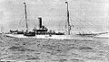 Admiralty-yacht-HMS-Iolaire-ship-Amalthaea-1908.jpg 648 × 374; 43 KiB
-
 Afternoon walk on Lewis (31016194117).jpg 4 608 × 3 072; 4,83 MiB
-
 Afternoon walk on Lewis (45230999724).jpg 4 608 × 3 072; 4,98 MiB
-
 Afternoon walk on Lewis (45231015254).jpg 4 608 × 3 072; 5,99 MiB
-
 Afternoon walk on Lewis (45231023244).jpg 4 608 × 3 072; 5,03 MiB
-
 Afternoon walk on Lewis (45955232721).jpg 4 608 × 3 072; 4,93 MiB
-
 Agricultural building, Grianan - geograph.org.uk - 1250354.jpg 640 × 480; 83 KiB
-
 Ailein Community Woodland - geograph.org.uk - 1262687.jpg 640 × 480; 86 KiB
-
 Aird Bheag - geograph.org.uk - 913820.jpg 640 × 481; 80 KiB
-
 Aird Bheag Bhràgair - geograph.org.uk - 1344436.jpg 640 × 427; 254 KiB
-
 Aird Bheag Bhràgair - geograph.org.uk - 1344440.jpg 445 × 640; 226 KiB
-
 Aird Bheag Bhràgair - geograph.org.uk - 1344449.jpg 640 × 427; 278 KiB
-
 Aird Bheag Bhràgair - geograph.org.uk - 1344452.jpg 640 × 427; 229 KiB
-
 Aird Primary School (aerial view).jpg 350 × 219; 17 KiB
-
 Airigh Garvaig - geograph.org.uk - 1252614.jpg 640 × 480; 94 KiB
-
 Airigh Lite - geograph.org.uk - 1252629.jpg 640 × 359; 69 KiB
-
 Airigh Sgridhe - geograph.org.uk - 1252814.jpg 640 × 359; 66 KiB
-
 Airigh Sgridhe - geograph.org.uk - 1252822.jpg 640 × 480; 113 KiB
-
 Aline forest and the hills of Park. - geograph.org.uk - 898482.jpg 640 × 480; 64 KiB
-
 Allt Doud - geograph.org.uk - 4229708.jpg 1 600 × 1 200; 688 KiB
-
 Allt Grunndal - geograph.org.uk - 1345407.jpg 640 × 427; 273 KiB
-
 Allt Grunndal - geograph.org.uk - 3728280.jpg 1 600 × 1 200; 863 KiB
-
 An Cnoc Ard View - geograph.org.uk - 5585768.jpg 640 × 353; 67 KiB
-
 Aonaig Mhor Tamna Siar - geograph.org.uk - 978341.jpg 640 × 429; 70 KiB
-
 Approach to Suainebost from the peat moors - geograph.org.uk - 2125023.jpg 640 × 480; 142 KiB
-
 Ard Bheag Landing Place - geograph.org.uk - 925224.jpg 640 × 481; 67 KiB
-

-
 Arnish Jetty - geograph.org.uk - 1445844.jpg 640 × 464; 97 KiB
-
 Ath a Mhail - geograph.org.uk - 1398369.jpg 640 × 480; 141 KiB
-
 Bagh Chliasmol - geograph.org.uk - 2561788.jpg 800 × 534; 150 KiB
-
 Baile an Truiseil - geograph.org.uk - 5516414.jpg 640 × 427; 88 KiB
-
 Baile na Cille - geograph.org.uk - 1347997.jpg 640 × 418; 232 KiB
-
 Baile na Cille - geograph.org.uk - 1348074.jpg 640 × 406; 194 KiB
-
 Barvas Cemetery - geograph.org.uk - 2672026.jpg 1 600 × 1 200; 544 KiB
-
 Beach at Port Mhor Bhragair - geograph.org.uk - 1618664.jpg 640 × 480; 100 KiB
-
 Beach, Loch Casgro, Isle of Lewis - geograph.org.uk - 5836500.jpg 1 459 × 1 946; 1,04 MiB
-
 Beach, Sròn Ruadh - geograph.org.uk - 1250405.jpg 640 × 480; 106 KiB
-
 Beached boat - geograph.org.uk - 935182.jpg 640 × 480; 84 KiB
-
 Beached fishing boat - geograph.org.uk - 1524540.jpg 640 × 480; 54 KiB
-

-
 Beinn Bhragair - geograph.org.uk - 1251299.jpg 640 × 359; 79 KiB
-
 Beinn Feusag - geograph.org.uk - 1251269.jpg 640 × 480; 92 KiB
-
 Beinn Mheadhanach from Teinneasabhal - geograph.org.uk - 974399.jpg 640 × 480; 47 KiB
-
 Beinn na h-Uidhe - geograph.org.uk - 3684805.jpg 2 560 × 1 920; 2,68 MiB
-
 Beinn nan Surrag - geograph.org.uk - 1309834.jpg 640 × 429; 94 KiB
-
 Ben Raah (Beinn Rà) - geograph.org.uk - 3684811.jpg 2 560 × 1 920; 2,75 MiB
-
 Bend in the South Galston River, Isle of Lewis - geograph.org.uk - 5128872.jpg 1 459 × 1 094; 464 KiB
-
 Beside Loch Stacsabhat - geograph.org.uk - 1347346.jpg 640 × 427; 244 KiB
-
 Bhaltos - geograph.org.uk - 1347753.jpg 640 × 411; 248 KiB
-
 Bhaltos - geograph.org.uk - 1347758.jpg 640 × 427; 259 KiB
-
 Blackhouse remains at Coig Peighinnean - geograph.org.uk - 3476145.jpg 3 264 × 2 448; 4,54 MiB
-
 Blanket bog on the Isle of Lewis - geograph.org.uk - 3522521.jpg 3 264 × 2 448; 5,95 MiB
-
 Blanket bog vegetation - geograph.org.uk - 3522527.jpg 3 264 × 2 448; 5,48 MiB
-
 Blanket peat bog, Feadan Leitir - geograph.org.uk - 1252855.jpg 640 × 480; 108 KiB
-
 Blanket peat bog, Feadan nan Sgarth - geograph.org.uk - 1252848.jpg 640 × 359; 74 KiB
-
 Blanket peat bog, Feadan Nan Sgarth - geograph.org.uk - 1252853.jpg 640 × 480; 101 KiB
-
 Blue and White Gravestone - geograph.org.uk - 1618668.jpg 640 × 480; 68 KiB
-
 Blàr an Eich - geograph.org.uk - 1252504.jpg 640 × 480; 112 KiB
-
 Blàr an Eich - geograph.org.uk - 1252507.jpg 640 × 480; 99 KiB
-
 Bo Ruadh - geograph.org.uk - 4597617.jpg 640 × 403; 72 KiB
-
 Boat House and Loch Suaineabhal - geograph.org.uk - 1522805.jpg 640 × 426; 207 KiB
-
 Boats on Caolas Sgalpaigh - geograph.org.uk - 2491820.jpg 640 × 455; 77 KiB
-
 Bog below Tom Earsail, Isle of Lewis - geograph.org.uk - 5029124.jpg 1 410 × 1 029; 460 KiB
-
 Bog beside the Pentland Road - geograph.org.uk - 1253307.jpg 640 × 359; 82 KiB
-
 Bog beside the Pentland Road - geograph.org.uk - 1253327.jpg 640 × 480; 112 KiB
-
 Bog near Loch Bacabhat Chrois, Isle of Lewis - geograph.org.uk - 5027769.jpg 1 094 × 1 459; 400 KiB
-
 Bog on Beinn Bhragair - geograph.org.uk - 1250432.jpg 640 × 480; 93 KiB
-
 Bog to the north of the Rathad a' Phentland - geograph.org.uk - 3522488.jpg 3 264 × 2 448; 5,99 MiB
-
 Bog, Allt Catriane - geograph.org.uk - 1252648.jpg 640 × 359; 95 KiB
-
 Bog, Allt Loch Nan Geadh - geograph.org.uk - 1252871.jpg 640 × 480; 102 KiB
-
 Bog, Blàr nan Lombaidean, Isle of Lewis - geograph.org.uk - 5445045.jpg 1 418 × 1 039; 301 KiB
-
 Bog, Druim Leinavat, Isle of Lewis - geograph.org.uk - 5817230.jpg 1 946 × 1 459; 612 KiB
-

-
 Boggy Pool - geograph.org.uk - 1346793.jpg 640 × 415; 192 KiB
-
 Boggy pool below Tomannan Mòra, Isle of Lewis - geograph.org.uk - 5433793.jpg 1 459 × 984; 383 KiB
-
 Bogs and shieling - geograph.org.uk - 1252549.jpg 640 × 480; 109 KiB
-
 Bogs north of the Pentland Road - geograph.org.uk - 1253168.jpg 640 × 480; 90 KiB
-
 Bogs south of the Pentland Road - geograph.org.uk - 1252971.jpg 640 × 480; 90 KiB
-
 Bona Ron - geograph.org.uk - 4597622.jpg 640 × 451; 71 KiB
-
 Boundary Stone - geograph.org.uk - 872234.jpg 640 × 480; 96 KiB
-
 Braes of Garry - geograph.org.uk - 922227.jpg 640 × 480; 132 KiB
-
 Bragar Bho Deas - geograph.org.uk - 1359356.jpg 640 × 474; 71 KiB
-
 Breakers on Rubha Beag - geograph.org.uk - 5894229.jpg 640 × 480; 237 KiB
-
 Breanais - geograph.org.uk - 1346460.jpg 640 × 427; 244 KiB
-
 Breanais - geograph.org.uk - 1346676.jpg 640 × 427; 227 KiB
-
 Breanais - geograph.org.uk - 1346686.jpg 640 × 399; 229 KiB
-

-
 Bridge at Ceann Shiphoirt - geograph.org.uk - 923156.jpg 640 × 480; 88 KiB
-
 Bridge at the head of Loch Sealg - geograph.org.uk - 841071.jpg 640 × 480; 122 KiB
-
 Bridge over the Abhainn Ghrìoda - geograph.org.uk - 1252886.jpg 640 × 480; 77 KiB
-
 Bridges over the Burn - geograph.org.uk - 1346705.jpg 640 × 427; 255 KiB
-
 Broad Bay House - geograph.org.uk - 1524594.jpg 640 × 480; 45 KiB
-
 Brollum Village Ruin - geograph.org.uk - 5492863.jpg 640 × 377; 94 KiB
-
 Bronze Age tools from the Adabrock hoard.jpg 675 × 900; 298 KiB
-
 Brù - geograph.org.uk - 4231439.jpg 1 600 × 1 200; 690 KiB
-
 Brù, Lewis - geograph.org.uk - 1524586.jpg 640 × 480; 39 KiB
-
 Bun Sgoil Uig - Uig Primary School - geograph.org.uk - 5519006.jpg 640 × 427; 93 KiB
-
 Burn at Da Loch Fhuaimeabhat - geograph.org.uk - 5191541.jpg 640 × 480; 69 KiB
-
 Burn flowing into Gleann Sgaladail - geograph.org.uk - 977496.jpg 429 × 640; 87 KiB
-

-
 Burn flowing out of Loch na Beiste - geograph.org.uk - 974309.jpg 640 × 480; 101 KiB
-
 Burn running out of Clar Loch - geograph.org.uk - 1266364.jpg 480 × 640; 101 KiB
-
 Cairn - geograph.org.uk - 3637742.jpg 3 648 × 2 736; 4,27 MiB
-
 Cairn at Lochan Vataleois - geograph.org.uk - 787588.jpg 640 × 480; 92 KiB
-
 Cairn Loch Mor Sanndabhat - geograph.org.uk - 920358.jpg 640 × 480; 130 KiB
-
 Cairn on Beinn Sheunta - geograph.org.uk - 3119163.jpg 1 536 × 2 048; 1,33 MiB
-
 Cairn on Guaineamol - geograph.org.uk - 1222475.jpg 640 × 480; 95 KiB
-
 Cairn on Mor Mhonadh - geograph.org.uk - 1222443.jpg 640 × 480; 84 KiB
-
 Cairn on Stacaiseal - geograph.org.uk - 5190573.jpg 640 × 480; 79 KiB
-
 Cairn on the top of Beinn na Cloich - geograph.org.uk - 5223510.jpg 640 × 480; 80 KiB
-
 Cairn with a View - geograph.org.uk - 1346798.jpg 640 × 403; 214 KiB
-
 Cairn, Beinn Choinnich, Isle of Lewis - geograph.org.uk - 5436835.jpg 1 459 × 1 094; 253 KiB
-
 Cairn, Eitacleit, Isle of Lewis - geograph.org.uk - 5808025.jpg 1 946 × 1 459; 645 KiB
-
 Cairn, Na h-Amaran, Isle of Lewis - geograph.org.uk - 5440112.jpg 1 438 × 1 019; 335 KiB
-
 Cairn, Roinn a'Roidh - geograph.org.uk - 911886.jpg 640 × 480; 104 KiB
-
 Cairn, Stacaiseal, Isle of Lewis - geograph.org.uk - 5234499.jpg 1 459 × 918; 237 KiB
-
 Cairn, Tom Mòr na Maoime, Isle of Lewis - geograph.org.uk - 5137132.jpg 1 459 × 890; 260 KiB
-
 Callanish Stones - Isle of Lewis, Scotland, UK - May 24, 1989 02.jpg 1 956 × 2 800; 1,96 MiB
-
 Callanishhebrides.jpg 1 572 × 997; 495 KiB
-
 Camas Bostadh - geograph.org.uk - 4018885.jpg 1 439 × 957; 894 KiB
-
 Camas Islibhig - geograph.org.uk - 1347139.jpg 640 × 428; 247 KiB
-
 Camas Islibhig - geograph.org.uk - 1347151.jpg 429 × 640; 245 KiB
-
 Camas na h-Airde - geograph.org.uk - 1347786.jpg 449 × 640; 246 KiB
-
 Camas Uig - panoramio.jpg 5 760 × 3 840; 24,42 MiB
-
 Caolas a Tuath bay - geograph.org.uk - 922937.jpg 640 × 427; 60 KiB
-
 Caolas Ghrèineam - geograph.org.uk - 1346330.jpg 640 × 424; 265 KiB
-
 Caolas Isgeir - geograph.org.uk - 1345720.jpg 640 × 427; 255 KiB
-
 Car Park - geograph.org.uk - 1344581.jpg 427 × 640; 177 KiB
-
 Carloway Football Club ground.JPG 640 × 480; 40 KiB
-
 Carloway01LB.jpg 4 608 × 3 456; 4,13 MiB
-
 Carloway02LB.jpg 4 608 × 3 456; 2,67 MiB
-
 Carloway03LB.jpg 4 608 × 3 456; 3,53 MiB
-
 Cattle Grid at Gress - geograph.org.uk - 194269.jpg 640 × 480; 81 KiB
-
 Cave below Eaglais an Fisich - geograph.org.uk - 1934034.jpg 3 216 × 2 136; 1,73 MiB
-
 Ceann Crionaig - geograph.org.uk - 918447.jpg 640 × 480; 193 KiB
-
 Ceann Rathad Bhru.jpg 10 000 × 977; 2,58 MiB
-
 Cemetery on the dunes, Tolsta, Lewis - geograph.org.uk - 1525356.jpg 640 × 480; 41 KiB
-
 Cemetery west of Valtos - geograph.org.uk - 1618906.jpg 640 × 480; 63 KiB
-
 Ceos and Loch Eireasort - geograph.org.uk - 2277859.jpg 640 × 480; 49 KiB
-
 Ceos with Loch Eireasort with the Harris hills behind - geograph.org.uk - 1725235.jpg 1 600 × 1 200; 441 KiB
-
 Chessman Sculpture - geograph.org.uk - 1348050.jpg 427 × 640; 241 KiB
-
 Children's playground - geograph.org.uk - 3468112.jpg 3 264 × 2 448; 3,76 MiB
-
 Children's playpark, Eòrpaidh, Lewis - geograph.org.uk - 2988094.jpg 1 024 × 577; 151 KiB
-
 Ciopeagail Bheag - geograph.org.uk - 839363.jpg 640 × 383; 49 KiB
-
 Ciopeagal Bheag Lochan - geograph.org.uk - 854696.jpg 640 × 480; 90 KiB
-
 Clach an Truiseil - geograph.org.uk - 1344939.jpg 427 × 640; 218 KiB
-
 Clach an Truiseil - geograph.org.uk - 5897370.jpg 480 × 640; 204 KiB
-
 Clach an Truiseil - geograph.org.uk - 5897374.jpg 640 × 480; 240 KiB
-
 Clach Aonghas Greumach - geograph.org.uk - 1657055.jpg 640 × 480; 183 KiB
-
 Clach Stein standing stone - geograph.org.uk - 1455931.jpg 640 × 480; 66 KiB
-
 Cladh Bhràgair - geograph.org.uk - 1344509.jpg 640 × 427; 227 KiB
-
 Cleascro - geograph.org.uk - 829078.jpg 627 × 434; 72 KiB
-
 Cleit an Eòin - geograph.org.uk - 1253335.jpg 640 × 359; 77 KiB
-
 Cleitichean Beag - geograph.org.uk - 1253253.jpg 640 × 359; 77 KiB
-
 Clett an Dùin - geograph.org.uk - 3685472.jpg 2 560 × 1 920; 2,47 MiB
-
 Cliff near Coig Peighinnean Bhuirgh - geograph.org.uk - 3728236.jpg 1 600 × 1 200; 848 KiB
-
 Cliff top views in Mangersta, Isle of Lewis.jpg 960 × 540; 112 KiB
-

-
 Clifftop cairns, Cadha - geograph.org.uk - 1452363.jpg 640 × 394; 41 KiB
-
 Clifftop cairns, Cadha - geograph.org.uk - 4229050.jpg 1 600 × 1 200; 694 KiB
-
 Closed loos, Dalmore - geograph.org.uk - 4229726.jpg 1 600 × 1 200; 552 KiB
-
 Cnap Liath from Aird Bheag Bhràgair - geograph.org.uk - 1344458.jpg 640 × 400; 225 KiB
-
 Cnoc an Fheòir - geograph.org.uk - 1263021.jpg 640 × 480; 89 KiB
-
 Cnoc Ard na Muilne - geograph.org.uk - 922664.jpg 640 × 427; 104 KiB
-
 Cnoc Ard na Muilne, Isle of Lewis - geograph.org.uk - 922660.jpg 640 × 427; 95 KiB
-
 Cnoc Ard Water Tower - geograph.org.uk - 5831734.jpg 3 000 × 1 688; 2,62 MiB
-
 Cnoc Dubh and Loch a' Chnuic Dhuibhe - geograph.org.uk - 1447717.jpg 640 × 480; 66 KiB
-
 Cnocan Loisgte - geograph.org.uk - 1347336.jpg 640 × 427; 232 KiB
-
 Coach roof, Gleann Shiadair, Isle of Lewis - geograph.org.uk - 5458394.jpg 908 × 1 353; 190 KiB
-
 Coast scenery west of Rubha Caol - geograph.org.uk - 1254741.jpg 640 × 480; 71 KiB
-
 Coast west of Rubha na Beirghe - geograph.org.uk - 1254888.jpg 640 × 480; 81 KiB
-
 Coastal scenery east of Cobha Sgeir - geograph.org.uk - 1250928.jpg 640 × 480; 70 KiB
-
 Coastal view near Carnais - geograph.org.uk - 1456139.jpg 640 × 480; 92 KiB
-
 Coastal view, Orasaigh - geograph.org.uk - 1474105.jpg 640 × 480; 60 KiB
-

-
 Coastline to the north of Sròn an t-Seileir, Isle of Lewis - geograph.org.uk - 5129557.jpg 1 433 × 1 060; 224 KiB
-
 Col on East Ridge of Suaineabhal - geograph.org.uk - 882564.jpg 640 × 428; 97 KiB
-
 Communication mast above Grabhair - geograph.org.uk - 1511501.jpg 640 × 426; 193 KiB
-
 Community Waste Facility - geograph.org.uk - 540889.jpg 640 × 480; 70 KiB
-
 Confluence of streams - geograph.org.uk - 839295.jpg 640 × 480; 130 KiB


.jpg)
.jpg)
.jpg)
.jpg)
.jpg)


.jpg)


_-_geograph.org.uk_-_3684811.jpg)


