Category:Itogon
Vai alla navigazione
Vai alla ricerca
municipalità di Seconda classe filippina  Mairie d'Itogon.  | |||||
| Carica un file multimediale | |||||
| Istanza di | |||||
|---|---|---|---|---|---|
| Luogo | Benguet, Regione amministrativa Cordillera, Filippine | ||||
| Popolazione |
| ||||
| Superficie |
| ||||
| Altezza sul mare |
| ||||
| Elettori registrati |
| ||||
| sito web ufficiale | |||||
 | |||||
Sottocategorie
Questa categoria contiene le 5 sottocategorie indicate di seguito, su un totale di 5.
B
- Binga Dam (3 F)
F
- Fianza Elementary School (2 F)
M
- Mount Ugo (1 F)
N
- Night in Itogon (1 F)
U
- Mount Ulap (10 F)
File nella categoria "Itogon"
Questa categoria contiene 40 file, indicati di seguito, su un totale di 40.
-
2024-01-29 Huey Helibucket.webm 43 s, 640 × 360; 2,4 MB
-
2024-01-31 Huey Helibucket 001.webm 37 s, 568 × 320; 4,67 MB
-
2024-01-31 Huey Helibucket 002.webm 1 min 57 s, 568 × 320; 20,95 MB
-
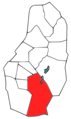 Benguet Itogon-location.png 331 × 556; 44 KB
-
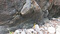 Dalupirip schist 01.jpg 4 624 × 2 604; 4,53 MB
-
 Dalupirip schist 02.jpg 4 624 × 2 604; 3,91 MB
-
 Dalupirip schist outcrop, Tinungdan, Itogon, Benguet, Philippines.jpg 4 624 × 2 604; 4,85 MB
-
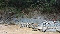
 Daylighted slope along the Baguio-Bua-Itogon road.jpg 4 624 × 2 604; 6,37 MB
-
 Deformed epidote lens in amphibole epidote schist.jpg 4 624 × 2 604; 4,24 MB
-
 Fianza Elementary School grounds, Dalupirip, Itogon, Benguet 01.jpg 4 624 × 2 604; 5,01 MB
-
 Flag of Itogon.png 1 000 × 600; 161 KB
-
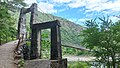 Gateway to a hanging bridge in Dalupirip, Itogon, Benguet.jpg 4 624 × 2 604; 5,11 MB
-
 Itogon Benguet Philippines.jpg 425 × 557; 86 KB
-
 Itogon overlooking Loakan Baguio (Itogon, Benguet; 12-05-2022).jpg 3 552 × 2 664; 4,37 MB
-
 Itogon municipal hall.gif 980 × 662; 435 KB
-
 Jointed diorite outcrop, Dalupirip, Itogon, Benguet 01.jpg 4 624 × 2 604; 5,45 MB
-
 Jointed diorite outcrop, Dalupirip, Itogon, Benguet 02.jpg 4 624 × 2 604; 5,19 MB
-

-
 Leucocratic dike intruding schist in Dalupirip, Itogon, Benguet, Philippines.jpg 4 624 × 2 604; 6,55 MB
-
 Leucocratic dike intruding schist outcrop in Dalupirip, Itogon, Benguet 01.jpg 4 624 × 2 604; 6,47 MB
-
 Leucocratic dike intruding schist outcrop in Dalupirip, Itogon, Benguet 02.jpg 4 624 × 2 604; 5,75 MB
-
 Lola teleng from itogon benguet.jpg 1 365 × 2 048; 695 KB
-
 Mt. Marikit, Tinongdan-Dalupirip, Itogon, Benguet, Philippines.jpg 4 624 × 2 604; 4,53 MB
-
 One Shiny Afternoon (110476347).jpeg 2 048 × 1 152; 436 KB
-

-
 Outcrop of Dalupirip Schist, Benguet, Philippines 02.jpg 4 624 × 2 604; 4,63 MB
-
 Outcrop of Dalupirip Schist, Benguet, Philippines.jpg 4 624 × 2 604; 6,17 MB
-
 Ph locator benguet itogon.png 299 × 299; 11 KB
-
 Ph seal benguet itogon.png 539 × 536; 48 KB
-
 Piece of greenschist from Dalupirip, Itogon, Benguet, Philippines 01.jpg 4 624 × 2 604; 2,48 MB
-
 Pyrites in diorite, P5 coin for scale.jpg 4 624 × 2 604; 4,93 MB
-
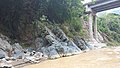
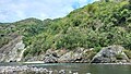
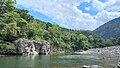
 Riverside gravels in Itogon, Benguet, Philippines.jpg 4 624 × 2 604; 4,21 MB
-
-
-
 Rounded gravels of the dried Agno riverbed with a leucocratic dike in the background.jpg 4 624 × 2 604; 5,73 MB
-
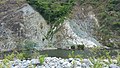
 Scarp of the 2018 Ucab Earthslide in Itogon, Benguet, Philippines.jpg 4 624 × 2 604; 4,81 MB
-
 Seal of Itogon.png 931 × 930; 922 KB
-
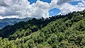 Trees in Itogon, Benguet.jpg 4 624 × 2 604; 2,26 MB
-
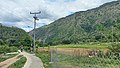
 Walkway and ricefields somewhere in Dalupirip, Itogon, Benguet, Philippines.jpg 4 624 × 2 604; 4,61 MB
-
 Walkway and ricefields somewhere in Dalupirip, Itogon, Benguet.jpg 4 624 × 2 604; 4,73 MB


.jpg)


.jpg)


.jpeg)


