Category:Jesus Trail
Zur Navigation springen
Zur Suche springen
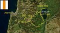
The Jesus Trail is a hiking and pilgrimage route in the Galilee region of Israel, designed in 2007, that traces the route Jesus may have walked (which may not be historically accurate).
For reconstructions of the route Jesus may have walked according to Biblical accounts or scholarly research, see Category:Maps of Jesus.
Fernwanderweg in Galiläa, der sich an Jesu Leben orientiert  סימון השביל מצפון לנצרת (משמאל על הסלע) | |||||
| Medium hochladen | |||||
| Ist ein(e) | |||||
|---|---|---|---|---|---|
| Benannt nach | |||||
| Ort |
| ||||
| Geografischer Startpunkt | |||||
| Geografischer Endpunkt | |||||
| Länge |
| ||||
| offizielle Website | |||||
 | |||||
Unterkategorien
Es werden 14 von insgesamt 14 Unterkategorien in dieser Kategorie angezeigt:
In Klammern die Anzahl der enthaltenen Kategorien (K), Seiten (S), Dateien (D)
C
J
K
M
S
T
Y
Medien in der Kategorie „Jesus Trail“
Folgende 18 Dateien sind in dieser Kategorie, von 18 insgesamt.
-
 Footpath to Mount Arbel.JPG 3.072 × 2.304; 1,45 MB
-
 Gospel Trail sign, Israel (5895998749).jpg 2.848 × 4.272; 4,44 MB
-
 Horns of Hattin.JPG 3.072 × 2.304; 1,23 MB
-
 IHM Jesus Trail 1.jpeg 960 × 500; 174 KB
-
 IHM Jesus Trail.jpeg 1.280 × 960; 667 KB
-
 Jesus Trail Mark.png 164 × 171; 457 Bytes
-
 Map of Jesus Trail-he.jpg 477 × 263; 32 KB
-
 Map of Jesus Trail.jpg 675 × 820; 436 KB
-
 Mount Arbel.JPG 3.072 × 2.304; 1,49 MB
-
 On the road to Capernaum.JPG 3.072 × 2.304; 1,51 MB
-
 PikiWiki Israel 30347 Religion in Israel.jpg 534 × 800; 140 KB
-
 Qana 0531.jpg 887 × 1.279; 172 KB
-
 The Gospel Trail (13982096673).jpg 5.222 × 3.871; 2,57 MB
-
 The Gospel trail sign Beit Keshet scenic route.jpg 2.560 × 1.920; 1,58 MB
-
 To the Horns of Hattin.JPG 3.072 × 2.304; 1,17 MB
-
 View on Sea of Galilee from Mount Arbel.JPG 3.072 × 2.304; 1,41 MB
-
 Walking on the Jesus Trail.JPG 3.072 × 2.304; 1,42 MB
-
 Walking the Jesus Trail.JPG 3.264 × 2.448; 1,9 MB

.jpg)


.jpg)


