Category:Kidmore End
Aller à la navigation
Aller à la recherche
localité britannique du comté anglais d'Oxfordshire  | |||||
| Téléverser des médias | |||||
| Nature de l’élément | |||||
|---|---|---|---|---|---|
| Lieu | South Oxfordshire, Oxfordshire, Angleterre du Sud-Est, Angleterre | ||||
| Superficie |
| ||||
| site officiel | |||||
 | |||||
Sous-catégories
Cette catégorie comprend 4 sous-catégories, dont les 4 ci-dessous.
Média dans la catégorie « Kidmore End »
Cette catégorie comprend 137 fichiers, dont les 137 ci-dessous.
-
 A view across the fields to Chalkhouse Green - geograph.org.uk - 67768.jpg 640 × 481 ; 57 kio
-
 A4074 at Green Dean Wood - geograph.org.uk - 2675670.jpg 683 × 1 024 ; 280 kio
-
 A4074 junction with B4526 - geograph.org.uk - 2820364.jpg 3 372 × 2 381 ; 1,63 Mio
-
 Bark - geograph.org.uk - 349331.jpg 477 × 640 ; 158 kio
-
 Benchmark beside floodlight on the Palm Tree restaurant - geograph.org.uk - 2675262.jpg 1 024 × 683 ; 251 kio
-
 Benchmark on ^2 Dyson Wood - geograph.org.uk - 2676709.jpg 683 × 1 024 ; 234 kio
-
 Car at Kidmore End - geograph.org.uk - 2896894.jpg 3 164 × 2 660 ; 2,58 Mio
-
 Chalkhouse Green Lane by Kidmore House - geograph.org.uk - 4609615.jpg 2 216 × 1 602 ; 1,16 Mio
-
 Chiltern Edge School, buildings and trees - geograph.org.uk - 5935828.jpg 1 024 × 683 ; 817 kio
-
 Chiltern Edge School, main entrance - geograph.org.uk - 5935827.jpg 1 024 × 683 ; 866 kio
-

-
 Country lane, Gallowstree Common, Oxfordshire - geograph.org.uk - 4755356.jpg 5 429 × 3 761 ; 4,71 Mio
-
 Craysleaze, Kidmore End - geograph.org.uk - 3058253.jpg 3 440 × 2 548 ; 2,29 Mio
-
 Deadman's Lane, Cane End - geograph.org.uk - 4612304.jpg 2 304 × 1 728 ; 802 kio
-
 Double gate on Kidmore End Lane - geograph.org.uk - 4610989.jpg 2 304 × 1 728 ; 1,58 Mio
-
 Dysons Wood House - geograph.org.uk - 2820934.jpg 640 × 480 ; 300 kio
-
 Dysonswood Lane - geograph.org.uk - 2676932.jpg 1 024 × 683 ; 362 kio
-
 Edge of New Copse - geograph.org.uk - 1048820.jpg 640 × 427 ; 161 kio
-
 Entering Gallowstree Common - geograph.org.uk - 2905988.jpg 3 348 × 2 240 ; 1,29 Mio
-
 Entering Kidmore End - geograph.org.uk - 4458748.jpg 2 560 × 1 920 ; 2,03 Mio
-
 Entrance to Dyson's Lodge from Dysonswood Lane - geograph.org.uk - 2677100.jpg 1 024 × 683 ; 317 kio
-
 Entrance to field on Kidmore Lane - geograph.org.uk - 4460866.jpg 2 560 × 1 920 ; 1,98 Mio
-
 Farmland near Cane End - geograph.org.uk - 1589643.jpg 640 × 480 ; 133 kio
-
 Farmland near Cane End - geograph.org.uk - 26770.jpg 640 × 480 ; 170 kio
-
 Farmland, Checkendon - geograph.org.uk - 2122884.jpg 640 × 480 ; 162 kio
-
 Farmland, Kidmore End - geograph.org.uk - 1556157.jpg 640 × 480 ; 88 kio
-
 Farmland, Kidmore End - geograph.org.uk - 1556158.jpg 640 × 480 ; 140 kio
-
 Farmland, Kidmore End - geograph.org.uk - 1595558.jpg 640 × 480 ; 140 kio
-
 FENO survey mark on SW side of A4074 - geograph.org.uk - 2675893.jpg 800 × 533 ; 188 kio
-
 Floating home for ducks and associates - geograph.org.uk - 989432.jpg 640 × 480 ; 145 kio
-
 Flooded road at Kidmore End - geograph.org.uk - 3953549.jpg 640 × 480 ; 488 kio
-
 Footpath towards Peppard Road - geograph.org.uk - 2577984.jpg 640 × 426 ; 152 kio
-
 Gable Cottages, Gallowstree Common - geograph.org.uk - 3675595.jpg 1 024 × 768 ; 240 kio
-
 Garden View - geograph.org.uk - 2174087.jpg 1 600 × 1 200 ; 563 kio
-
 Gate to the woods near Emmer Green - geograph.org.uk - 4610987.jpg 2 304 × 1 629 ; 1,3 Mio
-
 Harvest, Kidmore End - geograph.org.uk - 5934509.jpg 1 024 × 768 ; 214 kio
-
 Harvest, Kidmore End - geograph.org.uk - 5934527.jpg 1 024 × 768 ; 225 kio
-
 He could hit this ball right out of the county - geograph.org.uk - 3659815.jpg 3 648 × 2 736 ; 1,66 Mio
-
 Holly berries at Gallowstree Common, Oxfordshire - geograph.org.uk - 4290161.jpg 800 × 739 ; 148 kio
-
 Horsepond Road beside Bishop's Wood Camp - geograph.org.uk - 2819986.jpg 3 149 × 2 372 ; 1,61 Mio
-
 Horsepond Road junction - geograph.org.uk - 2820360.jpg 3 322 × 2 595 ; 1,3 Mio
-
 Horsepond Road south of Withy Copse - geograph.org.uk - 2820362.jpg 3 541 × 2 592 ; 1,99 Mio
-
 Horsepond Road, Cane End - geograph.org.uk - 2850940.jpg 3 644 × 2 232 ; 1,86 Mio
-
 Horsepond Road, Cane End - geograph.org.uk - 4621989.jpg 2 304 × 1 728 ; 860 kio
-
 House entrances on Wood Lane, Kidmore End - geograph.org.uk - 4609618.jpg 2 304 × 1 728 ; 875 kio
-
 House in Kidmore End - geograph.org.uk - 989417.jpg 640 × 478 ; 175 kio
-
 Houses at Gallowstree Common - geograph.org.uk - 5090108.jpg 640 × 427 ; 82 kio
-

-
 Ivy berries, Gallowstree Common, Oxfordshire - geograph.org.uk - 4284929.jpg 800 × 623 ; 92 kio
-
 Junction of Horsepond Road and B4074 - geograph.org.uk - 2820363.jpg 3 570 × 2 287 ; 1,48 Mio
-
 Kate's Cottage, Wyfold Road - geograph.org.uk - 5512946.jpg 640 × 480 ; 173 kio
-
 Kennylands Road at the junction of Peppard Road - geograph.org.uk - 4458496.jpg 2 560 × 1 920 ; 1,97 Mio
-
 "33 ... 34 ... 100 ... coming, ready or not" - geograph.org.uk - 593610.jpg 477 × 640 ; 113 kio
-
 Kidmore End at the junction of Chalkhouse Green Road - geograph.org.uk - 4458744.jpg 2 560 × 1 920 ; 1,99 Mio
-
 Kidmore End church - geograph.org.uk - 5512927.jpg 640 × 480 ; 155 kio
-
 Kidmore End Road at the junction of Chalkhouse Green Road - geograph.org.uk - 4458735.jpg 2 560 × 1 920 ; 1,97 Mio
-
 Kidmore End Road, Emmer Green - geograph.org.uk - 4458953.jpg 2 560 × 1 920 ; 1,92 Mio
-
 Kidmore End War Memorial Hall - geograph.org.uk - 5935829.jpg 1 024 × 683 ; 1,05 Mio
-
 Kidmore House - geograph.org.uk - 4609616.jpg 2 237 × 1 399 ; 1 009 kio
-
 Kidmore Lane, Kidmore End - geograph.org.uk - 4458965.jpg 2 560 × 1 920 ; 2 Mio
-
 Kidmore Lane, Kidmore End - geograph.org.uk - 4621988.jpg 2 304 × 1 728 ; 1,43 Mio
-
 Looking East across the Fields - geograph.org.uk - 37086.jpg 640 × 481 ; 228 kio
-
 Maple Hedge, Sonning Common - geograph.org.uk - 2670877.jpg 3 648 × 2 736 ; 1,67 Mio
-

-
 New Beech Trees - geograph.org.uk - 2850950.jpg 3 968 × 2 232 ; 2,44 Mio
-
 Nos 1 and 2 Dyson Wood - geograph.org.uk - 2675786.jpg 1 024 × 683 ; 193 kio
-
 Old Logs by The Chiltern Way - geograph.org.uk - 3427903.jpg 1 600 × 900 ; 396 kio
-
 Old Shop, Gallowstree Common - geograph.org.uk - 3675590.jpg 1 024 × 768 ; 235 kio
-
 Ordnance Survey Cut Mark - geograph.org.uk - 3894034.jpg 4 000 × 3 000 ; 3,97 Mio
-
 Paddock at Chalkhouse Green Farm - geograph.org.uk - 2577977.jpg 640 × 428 ; 213 kio
-
 Palm Tree (Ex Fox) - geograph.org.uk - 2083210.jpg 3 412 × 2 516 ; 1,3 Mio
-
 Palm Tree Indian Restaurant - geograph.org.uk - 4880140.jpg 640 × 480 ; 80 kio
-
 Palm Tree restaurant - geograph.org.uk - 2675430.jpg 1 024 × 683 ; 144 kio
-
 Pasture and woodland, Kidmore End - geograph.org.uk - 2331561.jpg 640 × 480 ; 194 kio
-
 Pasture near Chalkhouse Green - geograph.org.uk - 1776075.jpg 640 × 480 ; 126 kio
-
 Pasture, Kidmore End - geograph.org.uk - 6081518.jpg 1 024 × 768 ; 244 kio
-
 Pasture, Tokers Green - geograph.org.uk - 1776068.jpg 640 × 480 ; 103 kio
-
 Pastures, Chalkhouse Green - geograph.org.uk - 1776076.jpg 640 × 480 ; 149 kio
-
 Peppard Road to Reading - geograph.org.uk - 4780295.jpg 1 500 × 1 125 ; 118 kio
-
 Peppard Road to Reading - geograph.org.uk - 4780296.jpg 1 500 × 1 125 ; 177 kio
-
 Phone Box at Chalkhouse Green - geograph.org.uk - 3059577.jpg 3 048 × 2 276 ; 1,81 Mio
-
 Pond, Kidmore End - geograph.org.uk - 1418443.jpg 640 × 480 ; 111 kio
-
 Pony paddocks on the northern edge of Reading - geograph.org.uk - 1841234.jpg 1 024 × 683 ; 165 kio
-
 Pub Sign at The Reformation - geograph.org.uk - 4880131.jpg 480 × 640 ; 59 kio
-
 Reades Lane passes Kate's Cottage - geograph.org.uk - 3308113.jpg 3 648 × 2 736 ; 2,7 Mio
-
 Reades Lane, keeping things tidy - geograph.org.uk - 3308108.jpg 3 648 × 2 736 ; 1,96 Mio
-
 Reading Golf Course 12th green - geograph.org.uk - 3659880.jpg 3 648 × 2 736 ; 1,97 Mio
-
 Reading Golf Course 7th green - geograph.org.uk - 3659793.jpg 3 648 × 2 736 ; 1,88 Mio
-
 Reading RFC - geograph.org.uk - 2577923.jpg 640 × 428 ; 146 kio
-
 Reading Road in Cane End - geograph.org.uk - 4260544.jpg 1 500 × 999 ; 144 kio
-
 Reading Road in Green Dean Wood - geograph.org.uk - 4615091.jpg 2 304 × 1 728 ; 844 kio
-
 Reading Road near Vines Farm - geograph.org.uk - 4260543.jpg 1 500 × 999 ; 218 kio
-
 Reading Road runs through Green Dean Wood - geograph.org.uk - 4260542.jpg 1 500 × 999 ; 195 kio
-
 Reading Road, Cane End - geograph.org.uk - 4611026.jpg 2 304 × 1 728 ; 816 kio
-
 Restricted byway to Chalkhouse Green - geograph.org.uk - 2820940.jpg 640 × 480 ; 341 kio
-
 Rosehill riding stables - geograph.org.uk - 2577904.jpg 640 × 428 ; 206 kio
-
 Rosehill riding stables - geograph.org.uk - 2577913.jpg 640 × 426 ; 219 kio
-
 Shadows at Chalkhouse Green Farm - geograph.org.uk - 2577963.jpg 640 × 511 ; 219 kio
-
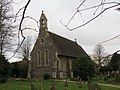 St John the Baptist Church at Kidmore End - geograph.org.uk - 3894033.jpg 4 000 × 3 000 ; 2,77 Mio
-
 Sweeney & Todd meat pie.jpg 3 205 × 2 900 ; 1,74 Mio
-
 Tanners Lane at the junction of Chalkhouse Green Road - geograph.org.uk - 4606594.jpg 2 304 × 1 728 ; 804 kio
-
 Tanners Lane, Emmer Green - geograph.org.uk - 4606595.jpg 2 304 × 1 728 ; 828 kio
-
 The A4074 to Oxford - geograph.org.uk - 4264769.jpg 1 500 × 999 ; 184 kio
-
 The A4074 to Oxford - geograph.org.uk - 4264772.jpg 1 500 × 999 ; 202 kio
-
 The centre of Kidmore End - geograph.org.uk - 4458778.jpg 2 560 × 1 920 ; 2,02 Mio
-
 The Chiltern Way near Chalkhouse Green - geograph.org.uk - 3427909.jpg 1 600 × 1 097 ; 397 kio
-
 The entrance to the Church of St John the Baptist, Kidmore End - geograph.org.uk - 4458410.jpg 2 560 × 1 920 ; 2,13 Mio
-
 The Hamlet - geograph.org.uk - 3823494.jpg 2 448 × 3 264 ; 1,71 Mio
-
 The Hamlet, Gallowstree Common - geograph.org.uk - 5512939.jpg 640 × 428 ; 156 kio
-
 The New Inn, Kidmore End - geograph.org.uk - 4606577.jpg 2 304 × 1 728 ; 816 kio
-
 The pond at Kidmore End - geograph.org.uk - 4458766.jpg 2 560 × 1 920 ; 1,92 Mio
-
 The Reformation - geograph.org.uk - 2819993.jpg 3 648 × 2 736 ; 2,66 Mio
-
 The Reformation - geograph.org.uk - 4880108.jpg 640 × 480 ; 96 kio
-
 The Reformation pub - geograph.org.uk - 3395401.jpg 4 320 × 3 240 ; 5,25 Mio
-
 The Reformation Public House - geograph.org.uk - 4879997.jpg 640 × 481 ; 99 kio
-
 The Well ^ Parish Notices - geograph.org.uk - 3675362.jpg 1 024 × 796 ; 353 kio
-
 Tokers Green Lane passes the Church of St John the Baptist - geograph.org.uk - 3307924.jpg 3 648 × 2 736 ; 2,38 Mio
-
 Tokers Green Pond in autumn - geograph.org.uk - 2820915.jpg 640 × 480 ; 354 kio
-
 Tokers Green, Oxfordshire.jpg 3 024 × 4 032 ; 4,65 Mio
-
 Towards Chalkhouse Green - geograph.org.uk - 2577938.jpg 640 × 411 ; 228 kio
-
 Towards Dysons Wood - geograph.org.uk - 3427898.jpg 3 440 × 2 232 ; 1,54 Mio
-
 Towards New Copse - geograph.org.uk - 1048815.jpg 640 × 427 ; 226 kio
-
 Tree on Kennylands Road, Sonning Common - geograph.org.uk - 4458506.jpg 2 560 × 1 920 ; 1,91 Mio
-
 Triangle with pond, Tokers Green - geograph.org.uk - 2820900.jpg 640 × 480 ; 323 kio
-
 Turning to Dysons Wood - geograph.org.uk - 3011172.jpg 2 272 × 1 704 ; 2,64 Mio
-
 Valley bottom - geograph.org.uk - 3011174.jpg 2 272 × 1 704 ; 2,18 Mio
-
 Waymarked Path near Cane End - geograph.org.uk - 2851208.jpg 3 556 × 2 232 ; 1,55 Mio
-
 Well at the junction of Tokers Green Lane, Kidmore End - geograph.org.uk - 4458385.jpg 2 560 × 1 920 ; 2,01 Mio
-
 Whitewood Heath - geograph.org.uk - 2850994.jpg 3 258 × 2 229 ; 1,49 Mio
-
 Wood Lane entering Gallowstree Common - geograph.org.uk - 4609424.jpg 2 304 × 1 728 ; 823 kio
-
 Wood Lane junction with Horsepond Road - geograph.org.uk - 3307939.jpg 3 648 × 2 506 ; 1,8 Mio
-
 Wood Lane, Kidmore End - geograph.org.uk - 4458964.jpg 2 560 × 1 920 ; 2,19 Mio
-
 Woodland by the A4074, Cane End - geograph.org.uk - 4609436.jpg 2 304 × 1 728 ; 1,77 Mio
-
 Bardolph's Wood - geograph.org.uk - 9186.jpg 640 × 418 ; 73 kio
-
 Bridleway near Highland Wood - geograph.org.uk - 349329.jpg 640 × 477 ; 152 kio
-
 Footpath to Kidmore End - geograph.org.uk - 349321.jpg 640 × 477 ; 110 kio
-
 Tankers Table Wood - geograph.org.uk - 349354.jpg 640 × 477 ; 149 kio


_-_geograph.org.uk_-_2083210.jpg)


